Kaluapele

On the Island of Hawaiʻi, Kaluapele (the pit of pele or Pele) crowns the summit region of the volcano Kīlauea.

08 May 2019

Wednesday, May 8, 2019. (Not?) Paying Attention, Part the Second

So.  Iʻm happy I left when I did yesterday.  Left to my own devices, the telling couldʻve easily gone off the rails.  Instead, I enjoyed the morning walk, and still the abundance of lehua bloom is an amazement.  As Iʻve said, the polymorpha - ness of the flowers are subtle in their many shades of red, the length of lihilihi (stamens), the numbers of individual flowers per cluster, etc.  Lehua come in many colors from the deepest red to the palest yellow, but in the park, at least along routes frequently traveled, live only the red ones.  

Not being the best photographer, I still wanted to share the following.  Iʻm learning how long from bud to seed.  The first picture was captured on April 24, 


and this one on May 4, ten days later:


Stay tuned for the release of seeds, pictured in an earlier post.

Spent three hours walking talking and enjoying with two friends, one a photographer.  A real one.  She was enthralled with the multivaried likolehua, as I was hunting for minute pūkiawe blooms.  

And a freshly unfurled frond of hāpuʻu pulu, shocking in its bright green youth.


In the same neighborhood are a few hāpuʻu ʻiʻi, this shot by cg, whom I met on the road Saturday last.  Note the stiff black hairiness of its clothing.  


Very very different than soft golden pulu of...hāpuʻu pulu.


Growing up, I often heard hāpuʻu pulu called "the wahine one", and hāpuʻu ʻiʻi "the kāne".  Now I know them to be different species.  And there are apparently hybrids.  Iʻll try remember to get a pic of one of those that I know.

And now a segue...back to the spending of money to "fix" things...

All  those pretty colors on the USGS Flow Map I posted yesterday are the historic flows.  "History" in this case being since 1840.  The Geologic Map of the Lower East Rift Zone displays a mosaic of a lot more colors; to me an indication of activeness of Pelehonuamea.

Geologic Map of the Lower East Rift Zone of Kīlauea

When the link opens, click on one of the products on the right-hand side.  I seem to always use the "Print Optimized PDF".

And as a refresher, hereʻs a screenshot of portion of the above map:


Keahialaka is at the center, with the streets in Leilani Estates displayed too.  Each color represents a distinct flow or a family of flows, by age.  

And another refresher, the Lava Hazard Zone Map, also compiled by USGS:

 USGS Lava-Flow Hazard Zone Map


And, a closeup of the area between Hilo and Pāhoa.


Kindly note, on the above image, the line drawn from Pāhoa eastward toward, and including Kumukahi, the place where the sun rises first in Hawaiʻi nei, the easternmost point in our archipelago.

Said line is Highway 132, the road from the "Y" at Lava Tree State Monument to the "4 Corners" intersection at Highway 137, the coastal route.   Please note, dear reader, that Highway 132 is ENTIRELY within Lava Hazard Zone 1.  If you are familiar with that road, youʻll perhaps know or remember that it was cut by a spatter rampart during the 1955 eruption.

And yet a third rendition with descriptive notes regarding Zones 1-3.

Another vivid memory I have of The Three Months is that of an older, presumably retired haole couple, who lived in Leilani Estates.  They were interviewed for a TV news program.  Their home was inundated, and the woman said something to the effect:  I thought Zone 1 was The Best!

Auē!  The foregoing maps and notes are my attempt to collate information and help inform and educate all, including government officials responsible for decision-making, affected residents, and persons in the general public, about the geologic realities of choosing to live on, or build infrastructure on, the Lower East Rift Zone of the most active volcano in the country.

Knowledge about Lava Flow Hazards must be the starting point for any discussions about rebuilding anything down there.  Itʻs not about Federal Money, State Money, or County Money, all of which (does it need to be said???) comes out of our pockets as taxpayers.  Itʻs not about Temporary or Permanent roads, itʻs not about whether Bob wants to rebuild his house at Kapoho Beachlots, or anywhere else in the region.  Decision-makers must have the will, the foresight, the knowledge and intelligence, to make really difficult decisions about the future of Puna ma kai.  And residents and property owners MUST understand the realities, and most importantly, the decades, centuries, and millennia of histories of Pelehonuamea and other elementals such as Kānelūhonua, he of the quaking earth, who are ultimately in charge of our collective fate.  Note too that lava flows are not the only geologic hazard of concern.  Severe earthquakes are often related to coastal subsidence as has been documented many times over the last two hundred years.  

So.  Please.  Read, learn, think, consider...and share this with friends and acquaintances.

As always, with aloha,

BobbyC
maniniowali@gmail.com

07 May 2019

Tuesday, May 7, 2019...(Not?) Paying Attention

Ear-ringing stillness.  Save for the distant soft twitterings of ʻapapane, tis a quiet morning here in Keaʻau ma uka.  No breeze, no rain; that in-between time of shifting weather systems.  More birds awaken and their song becomes a chorus, louder and louder, perhaps incited by the abundant bloom of lehua.  Entire ʻōhiʻa trees are enrobed in shades of red and crimson.  I wonder if the emissions of lehu - ash thrown out during our 62 lūʻōniu last summer -  served to fertilize the forests?  Or if tree roots, shaken by countless ʻōlaʻi, grew faster, and somehow increased nutrient flow to treetops?  Or...

One episode of shaking, of a terrifying series of ʻōlaʻi etched in my mind is


All those pretty dots strewn on the page above give absolutely no indication of the moments of terror each, on the table below, caused.  My home is in Mauna Loa Estates, the tight grid of streets at the center.  The 19 earthquakes were very shallow, brief, and violent.  As it turned out, the subsidence of pele in the conduit at Halemaʻumaʻu caused structural adjustments to the floor of Kaluapele and to caldera-bounding faults, many of which in the area near Volcano Village are buried by layers of ash and lava flows.  

From 4p to 8p we sat, and waited, and shook, and terrified, wondered What Next?  I called a friend who knows about these things, was reassured, and shook more.  The loudness of my house and its contents shaking was maddening.  The shaking...  Iʻll guess that many in the Volcano region will carry the memory of the shaking for a time to come.  

Perhaps "Highlight" isnʻt entirely accurate, but the memory of those four hours is seared into my circuitry. 

And as the sky brightens and limegreen brilliances of freshly unfurled oho hāpuʻu (tree fern fronds) reveal themselves, I wonder about memory.  And how if one hasnʻt memories of significant events, do they (those without memories) simply exist in ignorance, or are attempts made to learn?

Thus the "(Not?) Paying Attention" topic.  

Reading news of Recovery Efforts in Puna ma kai, the hundreds of millions of dollars wanted/needed/desired for those efforts, causes me to wonder:  Why???

We have to Plan.  We have to meet and discuss.  We have to reach out and gather information.  We have to assess.  We have to determine need.  We have to reach (or attempt to reach) consensus.  We have to envision The Future.


There are those musing about rebuilding Highway 137, the coast road between Kapoho and Pohoiki.  Some residents want to rebuild in or near Vacationland Hawaii.  County officials are, as I suppose they are required to be, tangled in a web of rules, regulations, permit requirements, conflicting and competing public and private desires, and who knows what else.

A new shopping center in Pāhoa is apparently on the verge of opening, if it hasnʻt already.  TryLook good at the map above:  "2014-2015 Puʻu ʻŌʻō June 27th Flow"  Middle of the left margin of the map.  Just to the left of the word (and town of) Pāhoa.

WHY?

There apparently is no memory, and/or any will or foresight on the part of County Officials as to how and when Pelehonuamea has shaped our island. And She will continue to do so.  My mind is boggled.  How on earth can a n y o n e contemplate rebuilding?  Must be because they know not of the histories of our home.  Royal Gardens, Kapaʻahu, Kalapana, Wahaʻula, Punaluʻu, the Chain of Craters Road, Kamoamoa, Kapoho Village buried in 1960, now Vacationland and much of Leilani Estates.  

Let me go walk and clear my head.

More tomorrow.

As always, with aloha,

BobbyC
maniniowali@gmail.com

30 April 2019

Tuesday, April 30, 2019. Who knew???

Itʻs 4am here, breezes sigh through the forest in darkness, quiet but insistent choruses of crickets drone on, and in the distance, coqui... still low enough in numbers we can pick out individual voices.

A year ago, or a bit more, we saw the little lava lake on the floor of Halemaʻumaʻu overflow several times, covering much of the floor of the home of Pelehonuamea.  Puʻuʻōʻō had been swelling, itʻs floor rising noticeably, almost hour by hour.


Above, one of the last times we saw Her at Halemaʻumaʻu.  Winds were slack, air voggy.

 A year ago, we were in the habit of walking to Keanakākoʻi almost daily.  I made a crude tally at one point, and the number was a surprise.  Over two thousand miles in five years or so.  In clear winter chill bundled absurdly in a random collection of colorful odds and ends, in rains and mists, in buffeting winds, (on March 14, 2015, the air was in the low-30ʻs):


and too, on rare vogless days when crispclarity made for breathtaking views.  


And then...

A year ago today, at about two in the afternoon, amidst a tumult of rains and winds, the East Rift Zone of Kīlauea, just downrift of Puʻuʻōʻō, ruptured.  Apparently, the gradual increase of magma supply in the plumbing system of Kīlauea exceeded the carrying capacity of subterranean pathways, and we witnessed the breaking point.  Mere rock could not withstand the insistent strain of pele. 

Of course there was no way of knowing what would ensue.  Who woulda thought?  Some certainly knew what was possible, but thinking of possibilities, the what-ifs, maybe whens, the somedays...all those musings can easily be dismissed with...Nah...Not goinʻ happen.

And then...here we be.


Not long ago, scientists at the Hawaiian Volcano Observatory installed a new webcam on the rim of the abyss.  We can peer vicariously into Her home, all the time wondering...

K3 Cam

This, on a particularly clear and dry day, view from more-or-less the southwest:


And a closeup of accumulations of kūkaepele, yellow sulphur deposits on steep slopes.  


Yesterday during our walk, winds were variably kona, and moisture from weekend rains, mingled with sulphurous gases, and made for pungent hydrogen sulfide experiences.  Lest we think that no one is home, a not-too-subtle reminder...


Thanks to ef for the reminder of the view at dawn, above.  Iʻm gazing at Maunakea in the distance, while the rosy slope of Maunaloa is to my left.  Also to my left if you look good, are bluish sulphurous fume rising from Halemaʻumaʻu.  Wisps of steam ascend from countless places on the new pali, as well as from the broken floor of Kaluapele.

And what we saw and experienced during The Three Months happened before, and will happen again.  Details of the works of Pelehonuamea and other elementals will, of course, vary, but without her, and them, weʻd have no place to call home...

"He Kau no Hiʻiaka", below, uses ocean-related metaphor to describe volcanism several hundred years ago...

 Birds awoke a little while ago.  Cricket choruses slowly replaced by complex songs of ʻapapane.

As dawn broke, below seen from the familar KE cam, we are reminded...


Iʻm off to Oʻahu for the day.  Reminisce, wonder, and remember...

As always, with aloha,

BobbyC
maniniowali@gmail.com


07 April 2019

Sunday, April 7, 2019. Where does blooming time go???

Ahhhh....Yes....Itʻs that lack of urgency thing again.  Iʻm still around, though it seems that busyness often gets the best of me.  I appreciate the "Where are you?" "When are you writing again?" queries.  It encourages me, though obviously not enough.  Know that if I decide to call it quits, which is unlikely, Iʻll definitely let you folks know.

So.  Many of us understand that the longer we live, each day progressively becomes a smaller fraction of our total time on earth.  Those smaller and smaller fractions, I posit, is the reason for time flying by faster and faster and...  here we are in April.  How can???

The walks to Keanakākoʻi continue.  Some say that Hawaiʻi doesnʻt seasons.  Itʻs always sunny, always warm, hours of daylight or nightdark donʻt vary much, but...I beg to differ.  Our subtle seasons are just that:  Subtle.  Or if you live on the heights or near the edges of rainfall gradients, maybe not so subtle.  Our low this winter past was maybe 38dF or so a couple mornings.  January was dry and warm, February was cold and wet, March was a blend, and today itʻs blueblue cumulus dotted sky, hot, and gentle breezed.  

The angles of our shadows on the road to KKOI shift, temperature warms, and plants do their thing at appropriate times.  This has been the time of blooming.  We enjoy a moderate bloom of lehua, but not all trees are into it at the same time.  Some ʻōhiʻa are laden with bloom whilst neighbors are merely leafy.

And you donʻt even have to try to see lehua.  Just...smallkine drumroll...

Be outside...Pay attention       Noho i waho...A maliu

Theyʻre right next to the road.  And yes, I maybe post too many lehua pics, but they fascinate me.  Buds hold lihilihi so tightly packed, itʻs a marvel that they unfurl the way they do.  Reminds me of monarch flutterbys we had in the classroom.  First the caterpillar, then the chrysallis, then when the adult emerges, they look pretty had it.  All wetish limp and wrinkled.  Then...patiently we watch as wings dry and expand...  Just like these buds...


Above, those pointy things on the underside of the leaf are galls.  A bug called a psyllid lays its eggs in leaf tissue, and the plant reacts by enclosing the egg and growing larva in scar tissue:  the gall.  Galls look bad, but as far as I know, they donʻt harm the plant.

And then we have lehua mamo.  "Mamo" after the color of the feathers of our extinct manu mamo, formerly cherished for featherwork.


And too we have ʻalani (orange).  The poly-morpha-ness of ʻōhiʻa constantly amazes.  Genetic diversity in the time of Rapid ʻŌhiʻa Death (ROD) is a comfort.  Not all ʻōhiʻa will die.  There are varying degrees of resistance, just as we enjoy endless shades of color, from the palest of yellow, to the darkest reds, and Iʻm pretty sure I pointed this out before, the liko (leaf shoots) too are just as variable.


Then lihilihi fall off, leaving seeds to develop in their pods.  Below, a few pistils hang in there.


 And pods swell and fatten...


ʻapapane thrill
breezes waft lihilihi
ʻōhiʻa full bloom

Yesterday I decided to do a sunrise at Keanakākoʻi.  Tried the day before, but my timing was off a bit, and I missed the pinking of the mountains.  Got to the parking lot at 530 yesterday morning:  the cacophony was astounding!  Dawn had just broken, and it sounded as though every single bird in the forest was competing for The Loudest Voice.  REALLY loud.  Twas an amazement.  And as I walked and sky lightened, flocks of ʻapapane with their intermittent thrumming wingbeats were there and here.  "Flock" in this instance = ten or so.  And the same thing has been happening at Kawaiʻapapane too.  Cool craziness.

And thanks to JT, there I was glorying in breathtaking beauty.  Looking at Maunakea, peeking over the horizon.


The closeup above:  Kūlani is the dark antennaed puʻu at the right.  I think that the two smaller puʻu seen below the summit of Maunakea are Kīpū (on the left) and Lālaʻau (right).

Kūlani, at an elevation of 5,500 feet, perhaps because of its prominence, is an important geographical boundary marker.  Itʻs where the moku (districts) of South Hilo, Puna, and Kaʻū meet, or if you choose, where the corresponding ahupuaʻa of Waiākea, ʻŌlaʻa and Keauhou are pili (come together or join). 

Just below, a blooming pūkiawe.  Pua are teeny tiny, phonecamera and operator not so great, thus the poor quality image, but I trust that youʻll get the idea.


Pūkiawe is a shrub with fruits ranging from white to dark red.  Lots of Christmas-time wreath makers use it because the plant and its fruits are dry, and hold up well in arrangements with no water.  Formerly, itʻs said that if an aliʻi wanted to mingle with makaʻāinana (common folk), pūkiawe was burned in a small fire and aliʻi walked through the smoke as a purification ritual. 

And below, the cauliflory-ness of kōlea lau nui, wherein the flowers grow and bloom directly out of branches.  Dark purple fruits are used to make a dye for kapa, bark makes a red dye, and kōlea wood is used for various purposes, including its charcoal, used as a pigment too.


And while not a "bloom", our hāpuʻu and ʻamaʻu continue to unfurl their pepeʻe.  First below, pepeʻe (fiddleheads) of hāpuʻu pulu still covered with that fuzzy pulu.


As fronds unfurl, pulu is torn, and mats of it flutter in breezes. 


ʻAmaʻu is smaller, its pepeʻe are more tightly wound, and rather than pulu, we see golden hair.


OK...And seen on a drive to Kealakekua and Kalukalu several days ago, ʻūlei and māmane in Kaʻū surprise with their abundance of bloom.  No pics right now for those.  I wonder if the lehu spewed last summer helped fertilize everybody?  

And perhaps that reference to lehu and The Three Months will serve as a modest segue.

Iʻve long been perplexed by what seems to be transpiring (or not) in our County government.  An issue is a request, apparently granted, for $50 MILLION dollars to do something or other with Highway 132.  Thatʻs the section of road between the "Y" at Lava Tree State Park, and the 4-way intersection near Waiapele (Kapoho Crater).  

Our recently remodeled Saddle Road, according to our State Dept of Transportation, cost $316 million for 48 miles, a little over $6.583 million per mile.  Hwy132 is buried for 3.2 miles (two separate sections with a substantial kīpuka in between).  That works out to $15.625 million dollars per mile.  How Can???  And the bigger question is WHY?  All of Highway 132 lies in Lava Hazard Zone Number One.  The worst.  Guarantee whatever is made as a fix will get buried again.

And the folks at Puna Geothermal Venture, working with residents of said previously lavalocked kīpuka, successfully opened a temporary road through PGV and Kapoho Land Company property (mahalo Lono Lyman) on April 1, 2019.  No joke.

And I heard from a reliable source that The County signed a $45,000 (Forty Five Thousand Dollar) contract with a questionable company based on Oʻahu for a LIDAR survey of the flow field to be used in construction planning for Hwy132.  Why?  HVO likely has gobs of LIDAR data, and even if they perchance donʻt, whatʻs wrong with a GPS on the dashboard of the bulldozer to show the operator the centerline of Hwy132?  

Iʻm really hoping that my math is seriously wrong, or I misread something, or misheard something, or maybe even dreamt something that seems like a version of reality.

A week ago, I emailed all Councilmembers and all their primary staff, asking for clarification on the numbers above.  So far, "Crickets" to use a current descriptor.  Nothing.  If my e-box fills up during the week, rest assured that youʻll learn whatever I learn.

While I continue to hope (gotta stay optimistic!), Iʻll be away for a week or so, returning to my desk on the 18th.  

As always, with aloha,

BobbyC
maniniowali@gmail.com

14 March 2019

March 14, 2019, Thursday, Reminders of ʻŌlaʻi and not-so-Random Curiosities

Whew!  That was a rattle...1255a yesterday morning, wakened out of a very sound slumber.  My first thought:  OH! Sheʻs starting again!  It was loud and jerky.  And it was dark, and the webcams were seeing darkness too, and I figured "What I going do?".  Wondered if there were any more collapses at the Lua, wondered where the ʻōlaʻi, the earthquake, was centered, generally wondered...  So I went back sleep.

The image above, for those of you who have been with me since summer last, is a familiar one.  The M5.5 ʻōlaʻi happened just ma kai of the Chain of Craters Road, kinda close to the Mauloa o Maunaulu pullout.  That linearish cluster of quakes in the vicinity are near the ma uka edges of those big pali Hilina, Poliokeawe, and Hōlei.  Pali are formed along zones of instability as the slopes of our mauna sometimes slipslide toward the ocean.  Not at all unusual.

I had wondered, since last August 2, after our last lūʻōniu (collapse explosion), when we might feel another ʻōlaʻi.  It was a bit unnerving, but dwelling on What If serves no useful purpose, so on we go.

There are our friends the Webcams:

HVO Webcams

LOTS to peruse and choose from, though my favorites are KEcam, and PEcam.  

Recently added was the K3cam, perched on the rim and peering into the abyss:


This view is vertiginous.  I get dizzy when I contemplate being there.  So steep and hundreds of feet deep and surfaced with loose rock, you cannot see the bottom.  Much of the time the K3cam doesnʻt provide a good view because of poor lighting, steams and vapors, rain...  But there are windows of opportunity.

Maybe because Iʻm so visual, I enjoy looking at the weathers, the lighting as the day progresses, where and when the sun and moon rise and set, what our ao lewa, our cloud-floating-above-lua are up to, all that.  Some may think "Oh just look the cam!  No need go outside!".  And of course my reaction would include:

be outside...pay attention!       noho i waho...a maliu!

You must be outside.  To smell, to feel on your skin the chill, the heat, the mists and torrential downpours.  Gotta.  Otherwise itʻs like watching somebody eat the ono-ist food and not being able to taste or smell it.  Torture...

OTHER NOTES:

The Hawaiʻi Board on Geographic Names has kindly posted a link to a sheet listing proposed names for Fissure 8.  The link is under the green HGBN:


Itʻs all part of a process.  I have a favorite, and perhaps you do too.  Those with kuleana for  Keahialaka, the ahupuaʻa in which F8 is located have input, and I have faith that a good decision will eventually be reached.

TryLook at the submittal by Larry Kimura.  He and others propose "Papalauahi", as not the name for Fissure 8, but as the name for the entire eruption in Keahialaka.  The packet submitted is chockfull of archival information, and makes for informative and provocative reading.

Pepeʻe do their thing:

As mentioned last time, growth burgeons.  Hāpuʻu, ʻamaʻu, uluhe and other ferns are sending out pepeʻe...uncoiling fronds.  Iʻm looking forward to watching again their young tender bright green lau tremble in breezes.  The understory of the forest always looks fresh and clean when fronds are young.


All three pics above are of hāpuʻu pulu.  Pulu is the golden fur covering the pepeʻe.  Birds sometimes use it to build nests, and in the old days, pulu was used to dress wounds, and to prepare bodies for burial.

In the 1800ʻs, pulu was an export from the Kingdom of Hawaiʻi to America, Australia, etc.  It was primarily used as stuffing for mattresses and pillows.  The Ahwahnee, a famous hostelry in Yosemite used it as such.  But.  While pulu is soft at first, it isnʻt particularly resilient and breaks down relatively quickly.

I assembled this table years ago from stats in Thrumʻs Hawaiian Annual.  UH Mānoa has it online.  BEWARE!!!  This is probably for weekend clicking only...when you have time to spare.

Thrumʻs Hawaiian Annual

It still boggles my mind that hundreds of thousands of pounds were picked, dried, bundled, and exported.  Boggling.  Hawaiʻi Volcanoes has remains of a pulu processing area along the trail to Napau crater.  It was an open field with stonewalled accessory buildings.  Pulu from there was shipped from Keauhou Landing, also in the park.  Amazing to contemplate, but pulu was harvested from many different rain forests.

About ʻaʻaliʻi:

He ʻaʻaliʻi kū makani mai au; ʻaʻohe makani nāna e kulaʻi
I am a wind-resisting ʻaʻaliʻi; no gale can push me over

The above is an oft-cited ʻōlelo noʻeau from Mary Kawena Pukuʻi alluding to how the people of Kaʻū are resilient.

ʻAʻaliʻi are among many plants in bloom now...Many mistake their seedpods for flowers, perhaps because the flowers are so small and insignificant, while the pods ripen to showy masses.

Iʻve been perplexed by their flowers and pods and what grows on which plant.  So I asked a friend:
So in some cases, perplexments are perfectly justifiable.  Go figure.  And to empower you folks:  Busʻ out the dictionary...

This is I think female with a teeny tiny pod developing, I think:


 This I think is male, with pollen hidden in flowers, I think:


 Mature red capsules.  Thanks, ac!


And my bestest favorite from Hualālai, what I call "black" though itʻs not.  Dark dark dark red.  Junk picture, but you get the idea:


OK.  Nuff for now.  I gotta get dressed and holo.

Till soon.  As always, with aloha,

BobbyC
maniniowali@gmail.com

24 February 2019

Sunday, February 24, 2019, Down there on the LERZ in Puna ma kai

The best laid plans, tra la la...

This year of the Earth Pig is, so far, a busy one.  We see masses of blooms on many trees:  mango and summer pea (ʻōlelo Hawaiʻi: peh-uh, for "pear" aka avocado), jacaranda in Kona ʻĀkau,  the startling gold trees in Hilo, previously mentioned bright orange African tulips in windward gulches, etc etc etc.

If you recall, last time I mentioned our drought.  So much for "midst".  Soon thereafter we had seven or so inches of rain up here, and rains over Hawaiʻi nei have continued.  Yesterday, driving home from Hōlualoa on Māmalahoa, the "ma uka road" from Kailua to Waimea, I wondered at the fog and low clouds caught in ʻōhiʻa and lama near the Scenic Point on the 1800 flow.  Different...

Different and equally amazing I think, is the map released by USGS HVO folks a few days ago:

2018 LERZ Flow Thickness Map


The imagery helps put in context the mindbending awesomeness of the prodigious work of Pelehonuamea.  Nine HUNDRED feet thick!  And of course she was able to do that because flows entered the ocean.


Volume of collapse at Kaluapele and pele erupted in Keahialaka are estimated at .8 cubic kilometers each, more or less.  In perhaps more familiar terms, 1,046,360,480 cubic yards.
Thatʻs a Billion + cubic yards.  

And I must say something (again) about reopening roadways in the region.  The Lava Hazard Zone has not changed because the eruption ended.  The area is still in Hazard Zones 1 and 2, the most hazardous.  

There are people whose homes and farms remain lavalocked.  Two sections of Hwy 132 are buried:  about 1.5 miles closest to the "Y" near Lava Tree State Park, and about 1.6 miles as it passes Waiapele (Kapoho Crater).  Total buried is about 3 miles.

Iʻve spent far too much time during the last several weeks talking to folks in our County Government.  People who work for us.  People in the Mayorʻs office, an informal hallway chat with the Mayor, Council people, the staff of Council people, Public Works people, construction people, geologists, Planning Department people, Department of Research and Development people...lots of people.  I wanted to know why hasnʻt work started on even a basic, temporary, gravel road to allow access for residents.

It all boils down to "Harry Said Gotta Wait Six Months".  Again, there is absolutely no physical basis, fact, or reason that a temporary route(s) canʻt be opened.  The eruption is over.  The "Six Month" claim, as explained by the Mayor to me, is because in 1990, when lava was inundating Kalapana, HVO scientists told him to "Wait Six Months" before repaving streets and roadways.  Of course back then Kīlauea was still erupting.  And erupted for another 28 years.  Why repave or fix, when pele may well come again? 

The eruption is over, and has been since September.  There is no reason or need to wait six months.

But still might be hot, but might get lava tubes, but get big cracks, but stay dangerous, but gotta make LIDAR, but gotta bore holes, but gotta survey, but gotta reach consensus, but gotta make Section 106 compliance, but you donʻt understand, but but but....

And meantime, residents are in limbo, not knowing when.

TryLook:


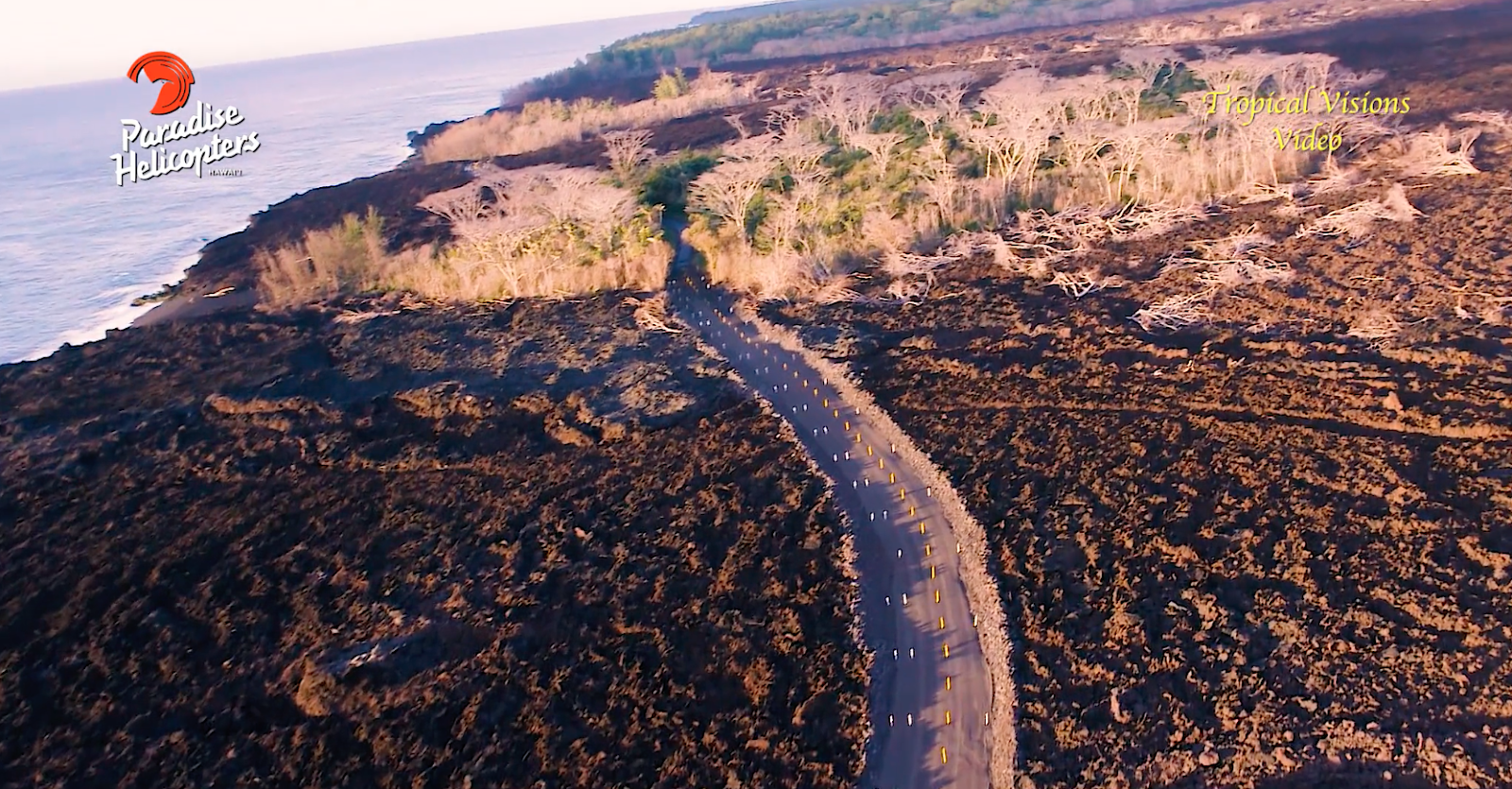
A tidy new road from the "Y" to the Puna Geothermal Venture property.  Up over the levee, across large māwae (fissures or cracks), across the bed of the channel, up the other bank, and home.  Didnʻt hear of any incidents of bulldozers falling into holes or sinking into hot lava, or....nothing.  They made the road.  And this is just ma kai of Fissure 8.

And The County made road over three fingers of pele to allow access to Pohoiki.  That road opened on December 6, 2018:


Someone in a position to know said Oh.  Easy.  Can do ʻum right now.  Money isnʻt an issue, hazards arenʻt issues, we just GPS the route and go.

Why we gotta wait?  Oh.  Gotta meet.  Gotta talk to stake holders.  Gotta gotta gotta.

If someone in the County would only issue a bulletpoint statement saying clearly and succinctly WHY gotta wait, Iʻm open to learning.  But it seems that all this is the usual governmental bureaucratic shibai.  Itʻs so much easier to say No.  No can.  Gotta meet.  Gotta wait.  No.  Nope.  ʻAʻole.  My head like explode...  They seem to forget, as do we sometimes, that They Work for Us.  

From our friend Mick Kalber:  TryLook new roads made by residents:

New Roads on Lava

S  I  G  H......

OK then...Stuff to do, life to live...

As always, with aloha,

BobbyC
maniniowali@gmail.com