Kaluapele

On the Island of Hawaiʻi, Kaluapele (the pit of pele or Pele) crowns the summit region of the volcano Kīlauea.

19 November 2019

Tuesday, November 19, 2019. That ʻŌhiʻa Lehua, etc.

From the wintry heights of Keaʻau, letʻs start with the etcetera...

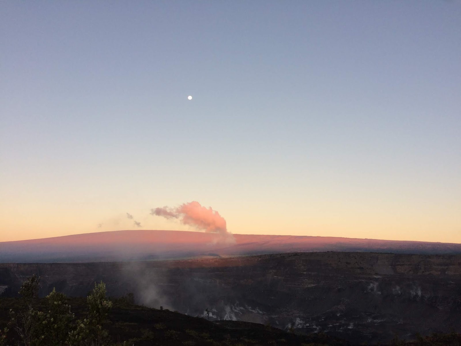
Winter has decidedly arrived as thunders roll across the skies, a light paka ua plop plops on the metal roof, and Poliʻahu, our elemental of snow who dwells on Maunakea, now too visits Maunaloa.  This, via the USGS HVO MLcam:


I have a fondness for the dictionary of Lorrin Andrews, published in 1865, and his almost poetic definitions.  As well as being Poliʻahu, the elemental,

poliahu  s. A soft touch; a gentle adherance of one thing to another.

Our bloomings of course continue.  As HK observed this morning, the yellow gingers at her home in Kona ʻĀkau are nearing the end of their season, and our bountiful roadside patches of both ʻawapuhi melemele and keʻokeʻo (yellow and white ginger) are barely lingering too.  The kāhili gingers here in Volcano are long gone, flowers being replaced by brilliant orange seed pods.  

Weʻll write more next time about other bloomings, but now, about That ʻŌhiʻa Lehua:


No Ke Aloha Pau ʻOle No Nā ʻŌhiʻa Lehua

(because of unceasing aloha for ʻōhiʻa trees)

Last Thursday, November 14, 2019, with friend Janice Wei, I walked to Keanakākoʻi.  We left Devastation Trail parking lot guided by the light of the moon, and enjoyed sunrise at the rim of Kaluapele.


Only after lingering and chatting with newfound acquaintances, Janice, an accomplished photographer, and I made our way back to our cars.  The stroll back took a couple of hours, entranced as we were by sights along the way.  

I was especially struck by one roadside ʻōhiʻa.


unremarkable
seemingly like all others 
but look closely there


and there, and there, and there too...

We observe and learn.  I live in a rain forest dominated by ʻōhiʻa, but they never fail to captivate.  People and ʻōhiʻa are similar in that each individual is unique.  We understand that humans are all Homo sapiens, but with genes allowing for subtle differences in skin tone, color and shape of eyes, texture and color of hair... and so with ʻōhiʻa lehua:  variable but the same.  

This one nondescript tree, one of many, became the focus of our attentions, and the following photos were generously provided by Janice.

I had been looking at the trees to my right, but got distracted by the māhu hoʻokino, hovering and shape-shifting.  The tree closest to me seems to be dying, but its taller columnar companion became our obsession.


That flash of red to the right of my fist caught my eye, then I started looking and seeing.  Iʻve been wont to comment on the lack of availability of word lists in ʻōlelo Hawaiʻi pertaining to features relating to plants.  But...I had never taken time to wander through Māmaka Kaiao, a dictionary of "new" words.  Itʻs available at wehewehe.org, and I spent time last evening learning.

First, a bit of very basic flower botany, via The Internet:


Yes, there are a multitude of flower species, but they have in common, parts needed to make seeds.  The parts donʻt always look or are positioned as illustrated, but the end result is hopefully the same:  fertile seeds.  

The Pistil is comprised (top to bottom) of the Stigma, Style, and Ovary.  The stigma is sticky, and captures grains of pollen.  Pollen plays the role of sperm.  After landing on the stigma, a pollen grain grows a tube that descends through the style, and if all goes well, fertilizes eggs held in the ovary.

The Stamen, comprised of an Anther and a Filament, produces pollen.  The filament holds the anther aloft, the anther actually makes the pollen.

Sepals are often greenish, and are the bottom or outer-most part of the flower.  Petals are the next layer, and are colored in ways to attract various pollinators.

The Peduncle is the stem that holds the flower or inflorescence (a group of flowers), and the Receptacle gives rise to and holds all the flower parts together.


As we shall soon see, pua lehua donʻt quite fit the "flower" mold.

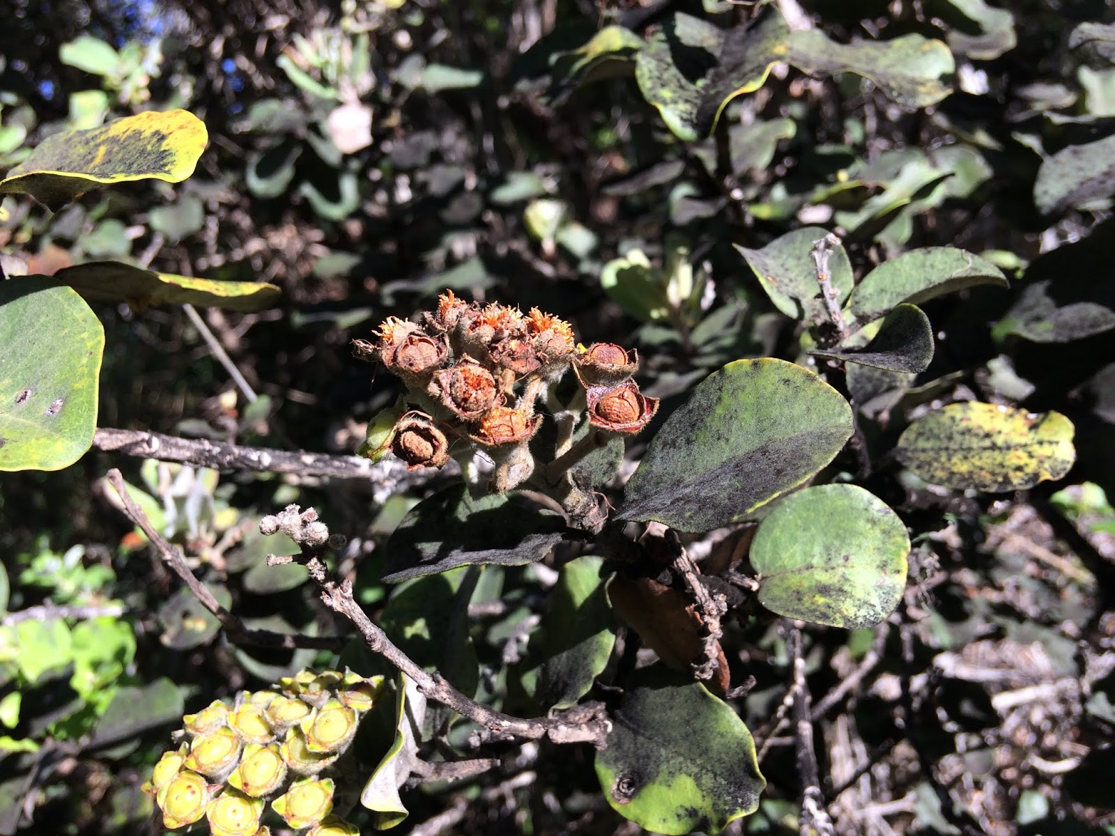
Tight buds.  Each lehua "flower" is actually many separate flowers.  The greenish-tipped fuzzys are sepals.  Dark red are petals.  Each "knob" is a separate flower.  The colors and degree of fuzziness (pubescence) vary on each tree.


Lehua flower cluster in full bloom.  This one is rather loose, making it easier to discern individual pua.


Close up.  The pua at the right has lost most of its petals.  Pointy greenish sepals remain.  The kukuna (pistil) is a heavier gauge, and darker red, and rises up out of the center of the flower.  The fat-topped kukuna just left of top center looks wet, because itʻs sticky.  That stickiness catches (ʻāpona) the pollen (ʻehu).  Most pōheo (anthers) are pinkish, while yellow ʻehu (pollen) can be seen on a few.


Below, as the pua ages, its pōuleule (stamens) fall off, leaving only kukuna (pistils) standing.

And we have a "situation".  Many refer to pōuleule and kukuna collectively as "lihilihi", because of their resemblance to eyelashes, an apt and beauty full poetic reference. 


And closer:

Wilted brownish red pōuleule (stamen) upper right.  Kukuna held in the centers of the cup, each surrounded by fuzzy sepals.


Seed pods swell...


And some retain their kukuna...


Finally, after several months, wahī (pods) begin to open, revealing precious cargo: countless blonde ʻanoʻano (seeds). 


Winds do their work, wafting seemingly fragile seeds away,


leaving behind empty shells:


A year or so later,  wahī remain, but are much weathered.


But hereʻs another thing...We have an endemic bug, a psyllid, a jumping plant louse, who favors laying eggs in ʻōhiʻa leaf tissue.  Irritated tissue becomes inflamed, then scars develop, forming galls.  There are apparently many different species of psyllid here, and many are host-specific, only making themselves at home on one kind of plant.  

One of my pics:


Back to Janiceʻs, top of leaf below:


Bottom of the same lau (leaf).  Note the fuzziness, just like the pua on the same tree.


And fortuitously, I had my trusty Swiss Army Knife, and sliced into a gall:


That yelloworange creature in its self-made home is a psyllid nymph.  An amazing stroke of luck, visible with ease via the magic of Janiceʻs camera work while I held the leaf between two fingers.  These little things live in leaf tissue, but seem not to have much impact on the health of the tree...


And, the blurries below, perched on pua lehua in the same area in June, may be the adults.  Iʻve sent a query to a researcher and will apprise you of details if/when they become available.  [NOTE:  050220.  Kinda late, but the pic below are of flies.  Perhaps a drosophila.  Or something.  But they are not psyllids.]


What a morning that was!  Started out commemorating the 60th of Kīlauea Iki, and see what happened???  We are so very fortunate...

And in the time itʻs taken to write this, thunderstorms have passed, sun is kinda out, the air still chill...and snows have begun to melt...


Good?  Till a few days from now...

As always, with aloha, and boundless gratitudes,

BobbyC
maniniowali@gmail.com


14 November 2019

Thursday, November 14, 2019. Remembering Kīlauea Iki

Whoa!!!  Has it really been two months?  The thought saddens me for some reason.  But, as Iʻve repeated, there is no sense of urgency to "report" now, though Iʻve been filling my black and white composition notebook (unlined, thank you) with lots of notes and ideas.  Weʻll play catchup in the coming days and weeks, with postings on a variety of stream-of-consciousness random and not-so random musings...

Greasing up the bearings:  

Today marks the 60th Anniversary of the start of the eruption at Kīlauea Iki crater in 1959.  Pic below is from a few days ago, taken from the Kilauea Iki Overlook.  The same place I stood with my family when we watched the spectacle.  The vent at the base of Puʻupuaʻi is shadowed, vegetation partially obscures views today, and the scene is oft decorated by that hovering cloud, the māhu hoʻokino (vapors that take shape: kr) created when hot vapors rise from the Lua, cool, and condense.  Yup.  Itʻs a favorite.


Pelehonuamea began her work by opening a line of fissures on the Kaʻū-side wall of the crater.  Streams cascaded to the floor and began creating a lava lake that ended up being 400 feet deep.  Following three pics are from USGS HVO... The bright dots on the floor are burning trees. 


In daylight, the view is perhaps not as compelling, but I think perspective is a bit better.  Keep in mind that the lava lake eventually rose to the base of the primary fountain seen below.


And then, as recently, visitors visited and were enthralled.  All the black in the eruption cloud is tephra, carried upward and downwind.  Tephra, again, is any volcanic product that falls out of a lava fountain.  Cinder, Peleʻs hair, Peleʻs tears, reticulite, all are tephra.  HK has shared a story of folks on Oʻahu going to the beach to gather cinder, for their gardens and potted orchids, that had made its way there via wind and wave.  It boggles the mind.


The pic above shows a still-growing Puʻupuaʻi (gushing hill), the hump to the right of the fountain.  The name was chosen as the result of a newspaper contest, though technically the hill never gushed.  The luaʻi pele (fountain) gushed and the puʻu was heaped.

Below are a couple of video clips.  The first includes both the 1959 Kīlauea Iki and 1960 Kapoho eruptions.  The second, by Fred Rackle, are clips of his films of Kīlauea Iki.

US Dept of the Interior: Eruption of Kīlauea, 1959-1960

Fred Rackleʻs Kīlauea Iki film clips

Rackleʻs are from the folks at CSAV (Center for the Study of Active Volcanoes) at UH Hilo.  Lucky for us we get to view both these treasures in all their historic quirkiness.

Grampa Rapozo drove us in his navy blue Pontiac (I think) from Honokaʻa.  Who knows how long that took, but Iʻll guess it was an all-day affair.  Being 8 then, my memories, are at best, spotty.  I remember a lot of traffic in Volcano.  I remember not having a lot of time to watch, listen to the roars, and feel the heat.  But, I remember...

And the LIFE Magazine cover below is somewhere in a box or file cabinet.  I copied it for an art class in intermediate school, though where the watercolor ended up is anyoneʻs guess.


And I remember too, seeing the glow from our ma uka kitchen window in Honokaʻa.  The measured distance is about 47 miles, over the shoulder of Maunakea.  I remember...


And sixty years later, Iʻm still watching and admiring.  This morning a friend and I decided to go to Kaluapele, to our favorite viewpoints on the rim across from Keanakākoʻi.  We left the Devastation Trail parking lot at 545a, walking down the moonlit road, and...  


Two others were out there too, visitors from, I believe, Bostonish.  Just the four of us in the whole world, there.  That dark patch on the far rim is the shadow of our cloudfriend.

After the sunrise light became daylight, jw and I stayed for a photo session, spending an hour or more portraiting a single roadside ʻōhiʻa tree.  It was a marvel:  tight lehua buds, full bloom pua, young seed pods with only lihilihi wahine hanging on, tight greenish fat seed pods, pods just opened with blond seeds sticking out, empty pods with shiny tan interiors, year-old dark brown pods fading into oblivion, galled leaves...It was a best time.  Lucky attentive us...


And on the way out, a stop to again admire that fat hoverer.  Because it morphs so quickly, I never tire of watching and paying attention.  The lei of cloud on Maunaloa are forming at the atmospheric inversion, which, I confess, I still donʻt understand.  Something about temperatures and physics and...Iʻll give Google another go and will add that to the update list.

TryLook again at the last three pics above, paying attention to the quality of the lighting.  So very different, it amazes that they were all taken this morning... 

Ahhhhh....

As always, with aloha,

BobbyC
maniniowali@gmail.com

09 September 2019

Monday, September 9, 2019. A Change of Season, paha?

In conversation, friends and I have commented on the brisk chill in the air of late.  Last week, the seasons seem to have changed.  First, in early early morning, weʻve had to add an extra quilt to the bed, and then the weathers at Puʻuhuluhulu have been much more variable.  Some days on the mauna have been by turns scorching skin searing and then in a few hours invigorating chill downpours or windblown mists and fogs to cool off.

MAUNA MATTERS

While noting the change of season of weather, we wonder if there will be an accompanying change in thinking and action of government agencies and their staff.  I was especially appalled by the skillsawing of our beloved Hae Hawaiʻi, our Hawaiian flag, by a person identified as a "State Sheriffs Deputy".  Photo below, a screenshot from Hawaiʻi News Now on Friday, September 6, 2019.  The reason/excuse given for the desecration of Ka Hae Hawaiʻi, was that the flag was nailed or screwed to a piece of plywood that had been nailed over the doorway of the structure.  To gain access to said structure (a purported library and/or learning center for keiki) illegally built on Hawaiian Homes land adjacent to Puʻuhuluhulu, the boarded up doorway apparently needed to be sawn open.  And with it, our flag.


One has to wonder:  Why?  Why the desecration?  Why the desecration by uniformed law enforcement officers?  As far as I can tell, there was no emergency necessitating the sawing of our flag.  Their flag.  Officers were in charge of the situation, and the gathered crowd remained behind barriers.  As happens when Iʻm feeling overwhelmed, I woke Saturday morning at 315a with the above image spinning through my brain. So I got up and did some research:

As kuʻuhoa hk has often pointed out, if there are questions or differences of opinion, GoLook The Law.  Above is the applicable Statute.  Seems pretty clear:  One Year Imprisonment, a $10,000 Fine, or both.  The bolded lines are mine, for emphasis.  One wonders if there will be any consequences for the sawer and/or his supervisor(s)?

One also wonders if The Department of Hawaiian Home Lands will be inspecting all structures under their purview to ensure that they are permitted, healthful and safe, as is the criteria.  Gov Ige stated in a HHN TV interview about the pictured structure:

"There is a strict permitting process to ensure that it is safe and it meets all the building codes.  Obviously none of that occurred in this structure, so we felt it important that we remove it."

And in the Honolulu Star Advertiser, Attorney General Clare Connors said that the building is an illegal structure and that invasive species perhaps were brought into a fragile area.

Grasping at straws.  If invasive species are at top of mind, why not inspect all vehicles transiting or stopping anywhere on Saddle Road to look for coqui, little fire ants, albizia seeds, and what-la?

I wish that there were consistency, that there were smart decisions and parameters, and enforcement, and, and, and... not picking and choosing how when where to enforce law.

And too [a last little rantlet] thereʻs the matter of a $3.5 million or so [so far] enforcement cost incurred by County of Hawaiʻi police.  In the Hawaiʻi Tribune Herald on August 30, 2019:

"The second week of enhanced traffic enforcement on Daniel K. Inouye Highway near Maunakea Access Road has netted more citations, arrests and criminal charges than the first week, Hawaii Police Department said in a statement Thursday.
"Police say 630 citations were issued in the weeklong period starting Aug, 22, compared to 610 the week starting Aug. 15. In addition, nine individuals were arrested with 16 charges filed among them. That compares to seven individuals arrested for a total of 13 charges the previous week.  ...  The 630 citations were categorized as follows, police said: speeding, 289; excessive speeding (30 or more mph above the limit), five; seat belts, 51; child restraints, 10; use of cellular phone or electronic device, three; excessive window/windshield tint, 11; driving without a license, 17; driving without insurance, 25; unsafe vehicle, 13; other moving violations, 14; no license plate, 22; regulatory infractions, 169; parking violation, one.
"Charges against those arrested include: DUI, two; theft, two; contempt of court, nine; driving without a license, two; and driving without insurance, one.
"During the enforcement, a stolen vehicle was located and two suspects arrested for the offense."
So.  I donʻt know that many, if any, or even some, enforcement actions by HPD were directly related to the encampment at Puʻuhuluhulu.  What Iʻm guessing is that many of those citations are related to the decreased speed limit between Mauna Kea County Park and the entrance to Pōhakuloa Training Area.  Motorists who donʻt pay attention to posted speed limits are easy prey.  Especially since Saddle Road was designed in such a way to allow us to go FAST.  Itʻs so tempting...
and then at KĪLAUEA
The debacle of Highway 132 continues.  Our County awaits a waiver from Federal Highways to extend the deadline for completion of the "temporary" Hwy132.  Itʻs too hot to pave.  Again, if the area is hot (which it is), and it steams when it rains (which it does), that means that Pelehonuamea is still active.  But no matter.  Despite all the nodding to the works of Pele; her role in causing pele to flow... The County sold out for money.  Tens of millions of dollars?  Shoot!!!  Weʻll take it!  Build "temporary" roads to Federal standards?  No problem!  Rip through the still-active body of Pele?  Why not???
USGS HVO

So much for consistency.  But wait, Bob!  There IS consistency.  Misguided, uninformed, greedy consistency.  Cʻmon, get with the program!
The photo above, taken on 080719, shows a bit of Waiapele (aka Kapoho Crater) on the right.  
Below, is part of Registered Map 1777, showing Kapoho, Kumukahi and environs, drawn in 1895 by AB Loebenstein.
 And an aerial from our friends at the Hawaiian Volcano Observatory (HVO) shows a similarly scalloped shore.
USGS HVO
What I most appreciate are a couple handwritten comments on Loebensteinʻs map:
"Sunken Walls of Fish Ponds" and "Coast Line 1883 survey now covered by high tide".  At the risk of beating a dead horse [wasting time], I marvel at the apparent lack of foresight on the part of our County and State officials.  In many matters.  Here, highways are being rebuilt, folks want to move back to Kapoho Vacationland, build a new small boat harbor on the new pele by Pohoiki, etc.  Iʻve shared a bit of the eruptive history of Puna ma kai and the Lower East Rift Zone of Kīlauea, and repeatedly asked "Why?"  Why rebuild?
Aside from recurring lava flows, thereʻs the inconveniences of Shoreline Subsidence.  See Loebensteinʻs notes.  And better yet, perhaps, these entries from the Hawaiian Dictionary by Pukui and Elbert:
Ka-poho
Land section and cone, Kala-pana and Makuʻu qds., Hawaiʻi; a village here was buried in the 1960 eruption of Ki-lau-ea. Ancient surfing area in Kala-pana, now called Kai-mū. Gulch, southeast Lā-naʻi. Point, Mō-kapu peninsula, Oʻahu, where salt was formerly obtained by evaporation of sea water. Lit., the depression.
Poho-iki
Coastal land section, possible future hotel development site, and surfing area, Kala-pana qd., Hawaiʻi. Lit., small depression (Pele is said to have dug a crater here).
poho
1. n. Hollow or palm of the hand, hollow of the foot, depression, hollow; 
Get it?  Poho...that sinking feeling (of land), rather than the mental depression caused by the sinking of land and loss of ones property.  Place names are informative.  We need to
be outside...pay attention!     noho i waho...a maliu!
At Halapē, just after the Thanksgiving Weekend ʻōlaʻi (earthquakes) on November 29, 1975.  Had two ʻōlaʻi that morning, a M5.7 at 335a, followed by the M7.7 at 448a.  I remember them both.  
USGS
The sinking has been repeated, and shall continue.  If we donʻt stop wishing it didnʻt, or stop the "Chance ʻum" attitude, or think that pele not going come again in our lifetime, then WE are the cause of our social and financial woes.  Nobody but us is to blame.
Stop It!  Otherwise, waste time.  Waste money...and not just lilla bit money, but tens of and multi-millions of dollars...all avoidable if Federal, State, County "officials" would just Tell People:  No.  No Can.  This is tough love.  We not going keep wasting our collective money.  There seems to be a sentiment:  Federal Dollars...FEMA money...Theyʻll pay.  Except that the "They" is us.  All of us...
Take a d-e-e-p breath...slowly exhale...
OK then.  Letʻs holo ma uka...
USGS HVO 082219
Lava, flows and tephra, layers and layers, baked for as much as 35 years at 2,000 degrees F = RedRock.  The lua of Puʻuʻōʻō is about 820 feet deep.  A wonder to behold.
USGS HVO 082919
At Kaluapele, a spectacular view of the pali on the floor, created during The Three Months of Summer 2018.  Pit at upper left is Kīlauea Iki, with its trail across the floor visible.  Dark patch upper right is the shadowed wall of Keanakākoʻi.  Small tannish horizontal patch upper right is the Puhimau hotspot, site of steaming ground that killed the shallow-rooted forest.  On the horizon, left to right:  Puʻuʻōʻō, Kānehuiohamo, Maunaulu.

And last, but certainly not least:
USGS HVO 082219
The location of the above photo is very similar to that on the title page of this blog, though this one was taken from a bit higher elevation.  Green Kapāpala Ranch on the slope of Maunaloa, former USGS HVO and Jaggar Museum buildings on the rim at right, and that pool of green water on the floor.  Said pool is slowly rising.  Turns out (if math is correct) the water table in Keller Well, just off the mid-left edge of the picture, is about 250 feet or so higher than the bottom of Halemaʻumaʻu.  If indeed the water pool is forming as water from the water table infiltrates the Lua through fractured rock, perhaps an equilibrium will be reached.  Perhaps.  
OK then.  Gotta run pick up clothes off the line as afternoon showers arrive...
As always, with aloha,
BobbyC
maniniowali@gmail.com

31 August 2019

Late Saturday, August 31, 2019. Topics a la La-Rain...

La-Rain is a long-time friend, and years ago, she introduced me to "Topics".  Because we talked kinda infrequently, to keep news updates on track and to try to prevent wandering conversations, we had Topics.  She'd pick, then I, and we'd talk story.

I keep intending to get with the program and write more frequently, then Life gets in the way:  The Mauna, bits and pieces of other writings and meetings, dealing with an arthritic knee, and on and on.  And now here it is September.  And here we go:

The Mauna

I've been sharing info up at Puʻuhuluhulu University with interested folks.  It's been fun, interesting, and challenging.  Up at 6,500+ft, the air is thinner, and commuting up for a few hours can be, I've found out, exhausting.  Then too, the weathers are always changing; calm, clear and skin-searingly hot one day, cool and foggymisty the next.  But we take it all as it comes and marvel in whatever scene is presented.  Folks of all ages, from many places throughout our archipelago, are excited about the learnings and I'm happy to be able to contribute.

A CORRECTION:  If any of you have attended one of my classes, I've talked about the two Puʻukole...one on Maunakea, site of one of the last eruptions there about 4.500 years ago, and a tan-reddish one across the way on Maunaloa.  HOWEVER:  The Puʻukole on Maunakea is correctly named.  The other, on Maunaloa, is named Puʻukoli.  Similar, perhaps, but different.  Mayhaps my ears misheard, or lack of oxygen confused me...I apologize for the error.  If it's clear skies tomorrow, I'll try remember to take photos...

Lots of pics and video are here and there online, and when up there, taking photos isn't a high priority.  I've been telling friends and acquaintances that no matter your feelings or thoughts regarding TMT (the proposed Thirty Meter Telescope) on Maunakea, visiting Puʻuhuluhulu would provide good, in-person, first-hand information.  Especially if one is skeptical about reportage, GoBeThere...

At Kīlauea and Halemaʻumaʻu

at the Keller Well, December 2018

The link above is to a Big Island Video News piece about the Keller Well, which was drilled on the floor of Kīlauea Caldera in 1973.  Itʻs 4,140 feet deep, and the local water table was found to be about 1,660 feet below the surface.  Itʻs believed that that water table is likely contributing to the pool at the bottom of Halemaʻumaʻu, about a half mile away.  The well is near the September 1982 lava flow, on the south (Kaʻū-side) of Kaluapele.  GoGoogle for technical papers.

The view below is in the other direction, toward the east, with Puʻupuaʻi (barely visible) at the middle top.


USGS HVO

Wai welawela:  hot fresh water... At about 160dF, itʻs not quite boiling, but gases escaping through the pool cause it to bubble, and sulphur and other chemicals in the gases are captured in the water, making it green.  Who woulda thought???


We live several decades, and some may expect "things" to be ever-the-same.  One value of education is we are able to study history, make observations and attempt to understand, or at least make some sense of, our surroundings.  The


be outside...pay attention     noho i waho...a maliu

thing.  But Iʻve learned that learning about something is entirely different than experiencing it.  Especially the still-incomprehensible Hulihia Kīlauea during The Three Months of 2018.
From the Hawaiian Dictionary by Pukui and Elbert:

huli.hia
Pas/imp. of huli 1, 2; overturned; a complete change, overthrow; turned upside down. Chants about Pele with verses beginning with the word “hulihia” are referred to as hulihia. See prayer, kualakai 2. Hulihia ka mauna, wela i ke ahi (PH 204, 225), mountain overturned, hot with fire. Hulihia Kī-lau-ea, pō i ka uahi (PH 197), Kī-lau-ea [Volcano] is overturned, darkened by smoke. Kaua hulihia, revolutionary war. (PNP fulisia.)
Hmmm...What if...What if weʻre entering, or are in, a period of general hulihia?  Just watch, listen to the news of the day...
USGS HVO


And then thereʻs Highway 132, the road between Lava Tree State Monument and Kapoho...

During construction, having dug down at least 15 feet,


USGS HVO

temperatures of 750dF (more or less) were recorded.  Itʻs too hot to pave (the Temporary Road) with asphalt, so our County geniuses are asking FEMA for an extension to the October deadline for completion of Hwy132.  SIIGGHHHH...


Rock is a really good insulator.  The 1959 lava lake in Kīlauea Iki is perhaps 300 feet deep and is still hot.  It steams when it rains.  Thick walls of our old stone churches maintain cool interior temperatures.  Pelehonuamea is still present.  Heat + Rain = Steam = Her... Not till her younger sister Hiʻiaka brings greenery does Pele yield.  And it matters not to our Mayor.  Or maybe it does, but the tens of millions of dollars of Federal Funding matters more.  And still, a year after, residents wait to return to homes and farms in kīpuka.

It we had paid several hundred thousand dollars for a gravel access road over the new flow, the access wouldʻve been done in January or February.  But what do I know???  Oh.  Oh... I know that when it rains down in Kapoho, on the new Federally Funded, Paved, Built-to-Federal Specs Highway 132, itʻll steam.  A lot.  Making driving just a bit hazardous.

Slow shaking of head...  And I think that Iʻm beginning to understand that in County lingo, "Recovery" means getting people back to Puna Ma Kai.  Building a new small boat harbor at Pohoiki, blessing the new shopping center in Pāhoa (not far at all from the 2014-15 lava flow), paving more roads and highways, etc etc etc.  That definition of insanity??? Doing the same thing over and over (1790, 1840, 1924, 1955, 1960, 1977, 1983-2018) and expecting a different result...

Back up at Keanakākoʻi

While lehua, save for the odd random ones, seem to be pretty much pau bloom, Iʻve been taking photos of a particular branch I visit on the way to Keanakākoʻi.  Trying to learn how long from bud to seed.  More or less...


 Photo above, April 24, 2018.                        


Same branch, photo below, today, August 31, 2018.


Above pic, as many are, isnʻt the best, but the seed pods are just opening (at the right).  A neighboring cluster is shown below.  The fuzzies are ʻanoʻano lehua, future ʻōhiʻa perhaps.


KOLOPUA:  fragrant, as air laden with the perfume of flowers

Though the blooming of kāhili ginger is an annual summer event up here, and the flowers are a spectacle, they are sneeze-provoking, and worse, the very thick rhizomes form mats, choking any natives desiring a foothold in the forest.  

ʻAwapuhi (gingers) bloom when days are long.  They bloom too when streetlights shine on them at night.  White ginger is a favorite, and is for me, sneezeless.  Weʻve had stretches of icky ikiiki weather...hot, nearly windless, humid, sticky, but that makes for kolopua.  Car windows wide open, driving down the hill between Glenwood and Mountain View, good noses can pick out sections where white gingers bloom, then in turn, the yellows.

I remember fondly a big patch in the back of Waipiʻo.  I call it Waimā, because itʻs not far from the end of the road there, the "index finger" of the valley.  ʻAwapuhi Waimā is white, but with a bright yellow heart


And another pesky weed up here is Glory Bush, or Tibouchina.  Easy to see why it was planted as an ornamental...


But given a choice, Iʻll take our beloved, besieged ʻōhiʻa lehua. Its tiny seeds hold the promise for future generations.  Thanks for the pic, ln...


Mauna Matters

As always, with aloha,

BobbyC
maniniowali@gmail.com