Kaluapele

On the Island of Hawaiʻi, Kaluapele (the pit of pele or Pele) crowns the summit region of the volcano Kīlauea.

31 May 2018

Kīlauea Update, Thursday, May 31, 2018, hmmmm at Halemaʻumaʻu

Back in the now breezy chilly heights of Keaʻau ma uka-most.  Sunlight filters through a thin veil of cirrus, and Ulunuiakamamalu, a guiding force in many lives, will be laid to rest later this morning.  We miss her.  At Halemaʻumaʻu, an odd thing is seen, given recent events.  The ashsteam plumes are minimal.  So much so, that the rim of the much-enlarged lua on the floor of Halemaʻumaʻu was/is visible at times.


on 041217, a puff of ash rises from the lake, and the rim of the small inner lua (pit) is visible at the base of the plume

at 650a this morning, steam, with the brownish haze of vog in the background


and at 720a, minimal steam and a glimpse of the rim of the lua inset on the floor of Halemaʻumaʻu

What does this portend?  Only time will tell.  No prognostications from me, thatʻs certain.

The trembling and shaking of the ground continues, though seemingly less frequently these days.  ʻŌlaʻi are unnerving.  Maybe not the event itself, but the noise is what I detest.  From when I was small, Iʻd plug my ears, jump around, and shout, trying to diminish the sound inside the rattling house.  Still Do Not Like It.

And I continue to fuss with buttons on the Earthquake graphic page.  These are at the summit for the past day:


I seem to feel those starting in the mid-to-high Magnitude 2.  Especially if theyʻre shallow and Iʻm at desk in my loft.  The quotidian few if weʻre lucky.  If not, too many to count.

And again, most of these ʻōlaʻi are related to structural adjustments of the summit region, resulting from deflation or subsidence.  A succinct Why? paper from USGS follows (thanks, MG).


and Pele and her pele continue to reshape the lands of Puna ma kai

Now fast-moving, then slow, then fast again, the ʻaʻā and pāhoehoe pele confounds.  Some get complacent and try to carry on, then Sheʻs Coming! runRunRUN!  I have said, and still say, for the good of all, including First Responders, heed Mandatory Evacuation notices.  They arenʻt announced frivolously.  

About the movement of pele

Both ʻaʻā and pāhoehoe move in fits and starts, but with slightly different looks.  

Clinkery crumbly ʻaʻā flows, thick to begin with, especially on flattish or slightly sloping terrain may pause their advance, and rise up if the volume feeding the flow lessens for a time, or if the active flow front widens.  The interior is still molten and the flow will inflate until a critical point is reached, then the ʻaʻā will surge forward for a short time, then slow down.  

Smooth pāhoehoe is a bit different.  Those flows typically issue at a foot or so thick.  Its skin "freezes" and forms as soon as the 2,000+ degree lava hits the air.  Pāhoehoe moves forward in many different anastamosing (The Word of the Day) fingers.  If volume decreases, the flow, not being able to move forward because of the confining skin or crust, will inflate to varying degrees, sometimes forming cracked steep-sided tumuli up to several feet tall.  When internal volume increases, rather than the front surging like ʻaʻā, inflated pāhoehoe will rupture, usually at a crack, sometimes several days after the initial flow is emplaced, sending out a thin flow to begin the process anew.

Hoping this makes some sense.  Hereʻs silvery phh oozing from a darker tumulus a few days older, on 120617, on the coastal flats in Hawaiʻi Volcanoes NP.


All this is meant so you can understand why the fast-slow-fast movement of the current flows can be maddening.  When will it reach the road?  When should I evacuate?  Where will it reach the road? ?????

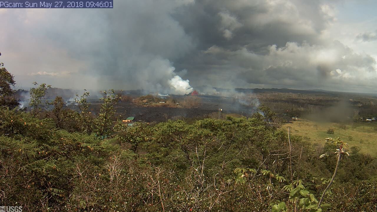
The Fountain, yesterday in Keahialaka, up to 200 or more feet at times:


Front or Terminus of ʻaʻā pele making its way toward the Pacific:


The USGS Flow Map

And the relatively low-level seismicity of the last 24 hours or so on the LERZ (lower East Rift Zone)


And finally, at Halemaʻumaʻu at 940 this morning, steam plume rises and inner pit rim visible.  I nervously wonder:  where has the lehu (ash) gone?


Till tomorrow, as always with aloha,

BobbyC

29 May 2018

Kīlauea Update, TUE, May 29, 2018, morning

ahhhh...That was a well-deserved and much needed break, and Iʻll be taking another later today, into tomorrow (WED).  I attended a joint birthday party for a grandniece (6) and her brother (1) in North Kona.  It was a delight, spending time with younger generations of bright-eyed and energetic people, and the foods...the potlucked foods were abundant, varied, and ono!  Mahalo piha to all.

And then there was the abundant noe uahi (volcanic haze or vog).  So widespread, so thick; so headache, stuck nose, and dry-eye-making.  Puʻuʻōʻō, at its elevation of 2,500 feet or so, and Halemaʻumaʻu at 4,000 feet sent their uahi ʻawa (sulphur smoke) up at higher elevations, and so I think that the noe uahi was better dispersed.  Now we have seriously hauna (smell of volcanic sulphur) poisonous fumes emitted from vents at near sea level, smoke from burning vegetation, laze and its gases from the (intermittent) ocean entries, along with the lehu (ash) and fume from Halemaʻumaʻu, most of the time being blown by trades around the south of the island, and collecting in the Kona Districts.  And up into the Saddle between Maunaloa and Maunakea too, the brownblue air makes an impressive display.  And always remember that for hundreds and hundreds of years, all these things have impacted residents here.  And somehow we deal with it all.


PLEASE READ and become better informed:  the 1955 USGS report by Gordon Macdonald about the LERZ eruption that year.  It details various phases during the eruption, various places and styles of eruption...Do Not Become Complacent!

1955 USGS Eruption Report: Macdonald


At the summit

ʻŌlai (earthquakes) continue as Kīlauea settles still.  The graphic below depicts ʻōlaʻi of magnitudes 3 and greater, for the last 24 hours or so.  Many, if not most of them can be felt, if only as queasy-making movement.  If you visit the Seismic page on the Hawaiian Volcano Observatory website [google:  kilauea webcam], you can fiddle with the buttons to the right of the map and see what else seismic is happening .  

The cluster of three ʻōlaʻi at the bottom are along Kulanaokuaiki, a pali ma kai of Hilina Pali Road, and part of the Koaʻe Fault System.


And of course here are "All" in the Summit Region.


The "big" news, though perhaps a bit late for the more-informed of you, is the presence of a second lua on the floor of Halemaʻumaʻu.  This new one is apparently emitting only white clouds of steam.  And too, note enlargement of the original lua.  See the screenshots on previous postings for other steam-ash duo shots.  Hereʻs the radar image from USGS HVO:


Below, the closer, white cloud is mainly steam on this rainy foggy morning up here.


at Puna ma kai, Pele is BUSY!!!  Perched Pond, Fountaining, Fast Flow

To me, the biggest recent news was the breaching of a perched pond on Sunday, 052718 at 7p or so.  

A perched pond forms when lava pools on a flat area or in a slight depression.  The volume of the feeding stream usually pulses, and the height of lava in the pool goes up and down.  The pool repeatedly overflows, and levees of hardened lava are built on its edges, allowing the surface of the pond to become perched higher than its original elevation.  Kinda like a bird flying higher and higher, and perching (halakau) to rest.  [[Yes.  Halakau.  Not Hakalau like the ahupuaʻa in Hilo Palikū (Hilo of the upright cliffs)]].

And I cannot help but mentioning a verse in Hanohano Wailea.  Kumu NK choreographed it exquisitely for us Makuanani.  And we tried our best:

"Halakau ʻo Kaʻiwa i luna lilo lā,   
Neʻe mai ʻo Ahiki i ke kualono.
Kaʻiwa rests high above,                
Ahiki moves closer to the mountain ridge"

Back to perching...So the pond gets deeper and deeper, and sometimes, if the levee is fragile, it breaks, allowing lava to flood out, as it did Sunday evening past.

And why "Mandatory Evacuation" does not seem to mean that, perplexes me.  Auē for the communities affected.  Now is when kuleana (responsibility) should be more than a slogan.

Transitions:  Fountains and Flows

The fountain below is perhaps two hundred feet tall.  Very active pāhoehoe on the right  is a flow headed toward HWY 132 (the road from the Lava Tree park intersection to Kapoho).  Compare with the image below posted Sunday.


The grassy area below at the right is now buried.  HWY 132 is to the right.


And just last Friday:


SEISMICITY

Seismicity at the coast is, thankfully, low, so weʻll not include that graphic.  

OCEAN ENTRY LAZE

The Reports inform us that only residual lava is making its way into the Pacific, thus the laze plume is lazy, if present at all.

FLOW MAP

And hereʻs the most current Flow Map:


The weathers today:  rainfogfograin here there.  Pelehonuamea has gone undercover for the time being, at least from our webcam views.

Till next time, as always, with aloha,

BobbyC

27 May 2018

Kīlauea Update, SUN, May 27, 2018, late morning

yup...Still here.  Getting a late start.  Managed to stay in bed till 545, after the annoyingly regular, these days, 315 wake up, and willing myself to go back sleep.

The coming several days Iʻll be in and out.  Trying not to be OCD about the blog.  Three + weeks in, we all need to take breaks; even if Pele is tireless, we arenʻt.

OK?

Oia mau nō (same as usual)

Halemaʻumaʻu continues pulsing ash, steam, ash and steam, almost playful in her work, Pelehonuamea as always, is certainly riveting and absorbing.

From Volcano House cam, we got to see a mistbow this morning, that subtle arc of light:


And while we may focus on lehu (ash), sometimes her exhalation is invitingly soft...


And whilst all that huffing, puffing, and exhaling is going on, still the ʻōlaʻi persist.  I play with the + and - on the Earthquakes Page.  Gives one different perspectives about reality...the center round below is Halemaʻumaʻu, with the confetti being lots of mostly small ʻōlaʻi.


Then going higher, the situation may look more intense:


And, despite what Media reports would lead ius to believe, if we have a W I D E perspective... It doesnʻt look THAT bad, especially for much of the Island of Hawaiʻi...


Butbutbut...these are "only" the ʻōlaʻi.  Pretty sure most would agree that the airs can be horrendous.  And Iʻve heard from friends, that the south and west regions of our isle are at times seriously hauna (the smell of volcanic sulphur).  Far-reaching are the effects affecting our entire populace in ways big and small...like the house-wobble felt...again...and again...as I write.

in Puna ma kai, ʻōlaʻi seem to have moderated


though the pele continues unabated, here, there, here again... this morning right up to the green-roofed building (below) in the Puna Geothermal Venture complex.  Look carefully, and you can follow the edge of the luaʻi pele (lava flow) to the right, where it paused at the edge of the grassy field.


And according to a USGS HVO report, pele was/is cascading into Pawai, one in a line of three adjacent lua just off the left side of the image above, (USGS topo map below).


And I think that the "PGcam" is on Puu Pilau, just east of "Geothermal Well", at the bottom of the upper area colored white above.

Below, the most recent USGS HVO Flow Map.  Compare with the zoomed-in topo above.  Using Kahuwai, Puʻulena, and Pawai for reference might be helpful.


And with that, Iʻll leave you folks to your own devices, electronic or otherwise.  I hope to check in tomorrow (Monday) afternoon.

As always, with aloha,

BobbyC

and if you have questions and desire a private forum, email me at

maniniowali@gmail.com

26 May 2018

Kīlauea Update, Saturday, May 26, 2018, 930a, the morning for Ilima...

[[a Prefatory Note:  uhdunno...Tis beyond my ken...Again, technology perplexes, befuddles, causes consternation, etc.... After saying yesterday, that the "Follow" link (if one supplies an e-dress) wasnʻt working, I got an email from "Dispatches from Volcano", a couple days after submitting "Follow", notifying of a new post.  Mayhaps it takes processing time, or what-la...
Maybe give "Follow" a try again if you desire, and patiently await results.]]

JUST as I was waking this morning, I dreamed I saw (NOT Joe Hill) my parents at our home in Honokaʻa.  First, friends and I were puttering in Maʻs bedroom, maybe fussing, sorting stuff in her closet.  There was a long box, like the kind in which flowers are shipped, on the bed, and I took a key to a lock I knew from the box.  The key had a long central channel running its length, and went with an inexpensive lock.  Other friends were talking story, puttering, and hanging out on the patio outside.  All the shrubs had been severely pruned from the Waipiʻo and ma kai sides of the house.  And there was scaffolding erected a few feet off the ground on those sides.  I walked along the Waipiʻo, then ma kai side, and my parents were near the gatedoor to underneath the house, wondering where the key to the lock was.  I pulled out the key and unlocked the lock.  Parents walked down and out of sight around the corner, having a pleasant chat.  And I puzzled at the unusualness of all those people in and at our home.  And then I woke up.  Dad died on 111101, and Ma on 020909.  And the dream was in color with sound.  And why tell you all this?  Beats me... I guess because I can.

And walking to the kitchen, the room glowed pink.  Thin thin overcast, with just the right dawnlight, made me feel as though I was inside that towering pink cloud over Puʻuʻōʻō several weeks ago.

TODAY AT THE SUMMIT REGION OF KĪLAUEA

BIG ash at dawn.  Those webcams are addictive.  There are two on the edge of Kaluapele: one in the tower at HVO:

KIcam at HVO

and the other on Volcano House, outside the back, crater-side door:

VHouse CAM

Click on images, then RightClick to Save...

A screenshot of a USGS video from Volcano House at 6p on TH, 052418, shows two plumes rising from Halemaʻumaʻu (HMM):  the left dark ashy, and the right white steamy:

VID HMM from VHouse, TH, 052418, 6p


And those two continue today...


No idea how or why, but looks to me that the lua on the floor of HMM is big, and maybe there are two?  Time will tell.

cool tri-color at about 540a today

There are, of course, ʻōlaʻi (earthquakes) at the summit.  One thing to note:  After an eq, the initial magnitude reading is reviewed, and it may, and with bigger ones, often does, change.  Media seems to get stuck with the initial.  So yesterdayʻs "M4.4" at 12:43:40, was downgraded to a M4.0, a fairly significant difference to me.  And it was 0.2mi deep (or shallow) which makes for a more jolting experience, (as my house wobbles from smaller ones). 
Pretty sure youʻll be able to see the url address at the top of the image below.


AND WHAT IN KEAHIALAKA?

BRIGHT this morning, and the kinda of slack airs make for serious hauna (smell of volcanic sulphur):


And ʻōlaʻi are fairly quiet (no Reds), and the ERZ (East Rift Zone) Tilt seems to be leveling out a bit...


Two Days of ERZ Tilt.  Big blip is the M4.0eq yesterday at 12:44pm


And we close with a lovely Hitchcock-esqe view from USGS of Fissure6 yesterday morning, 052518.  Pāhoehoe also means "satin", as in the drapeable fabric.  Note the silver-grey (hot, fluid, fresh) on the (not much) older very dark grey:

pā.hoe.hoe1. nvt. Smooth, unbroken type of lava, contrasting with ʻaʻā; to turn into pāhoehoe lava (see ex., namu 2).
2. n. Satin. Pāhoehoe lau, brocaded satin.


OK then.  On with the day.  Stay safe, be well, and try help those in need as you are able.

As always, with aloha,

BobbyC

25 May 2018

Kīlauea Update #2, FRI May 25, 2018, 340p, she boggles the mind

Always something new, different, and simply amazing.  

Looks like there are two lua on the floor of Halemaʻumaʻu.  How else to explain this?

And weʻve been rolling around all day up here...

Man, oh man...

More tomorrow.

bc
950a this morning

310p this afternoon

and the double-barreled shot, shortly afterwards from the Volcano House cam this afternoon at 315p:


she neverceases
variety is the spice
keeping us alert

bc

Kīlauea Update, Friday, May 25, 2018, at 0830 in the morning rain

[[start with a NOTE:  that "Follow" button so you can get Auto Updates isnʻt working.  Or rather, I canʻt get it to work.  And I donʻt want to deal with it now.  So best thing is to simply BOOKMARK the blog and check in when can.  I apologize for the junk customer service.]]

Hūi!!! You folks...

Still going... And our lives continue.  Took a break yesterday and spent time erranding in Hilo.  And our native kou are in bloom.  And friends helped me gather.  And two lei were strung.  And we used ʻili hau I processed.  And the lei kou were gifted to two women.  And one...her dad planted a kou tree in their yard in Hāna decades ago.  And she, a stranger, knew what the pua were and commented on them as they were being strung.  And she was adorned.  And tears welled. And we were strangers no longer. And the other went to a kind gentle friend.  And she was surprised.  And there was no occasion.  And Iʻll share a photo of the lei when I get it.  And there was aloha shared.  And thatʻs how we manage...

And I got it...mahalo piha, cw:


Looks like Pele is getting busier in Keahialaka.  Remember to look at the HVO Photos & Video.  They have informative captions, and of course the imagery is excellent.

HVO Photos & Video

Weʻll start at Puna ma kai this morning:

The image below, at sunrise, has good contrast, so the pele is easily visible.  All the lava on the right, I think, is from māwae (fissures) reactivated yesterday.


According to HVO, magma (lava thatʻs still in the ground) in the ERZ (East Rift Zone) is steady state.  No big inflation or deflation.  Kinda makes me nervous.  If the faucet is just left on...but maybe Halemaʻumaʻu is still draining downrift...or something.  Just gotta wait and see.  Because Pele will work till she moves on to another project.

Her ʻōlaʻi down there are quite low key.  Again, oia mau nō...


HVO Photos & Video has aerial images you can try correlate with the map below.


And at 741a we just had (another) gentle shake.  So so so many of them.  But what you going do???

Letʻs go up the hill...

to the foggy gentle rains of the rain forest... When I used to work the Entrance Station at The Park, on rainy days a frequent question would be "Does it always rain here?".  Never ever on those gorgeously brilliant sunny days would anyone ask "Is it always sunny here?".  Expectations...

Summit region ʻōlaʻi are scattershot.  Again, making the bed comfortable during a time when magma is apparently draining from under Halemaʻumaʻu.  Iʻm becoming accustomed to the spread out little red dots.  I think.

The 741a was a shallow 3 or so near HVO.  If you go to the HVO Seismic page, and play with the + and - at the upper left corner, and click and mousedrag the image around, and hover the cursor over the list of visible quakes to look at specific ones, of course all in turn, youʻll perhaps gain a bit of understanding of whatʻs happening where.  

HVO Seismic


And the trades still blow, and we remain grateful for that.


And The Media...the media continues to sensationalize, not apparently knowing or caring that their quips and HEADLINES are wreaking havoc and destruction on our economy.  Way worse than what Pelehonuamea and her pele are doing.  What an incredibly sad state of affairs.

This is what many see, and seemingly believe, sent me by a friend:


Kinda short today, but letʻs leave it at that...

As always, with aloha,

BobbyC


be outside...pay attention       noho i waho...a maliu
hiilei kawelo on hpr

24 May 2018

Kīlauea Update, Thursday, May 24, 2018, miscellanea

Another misty morning...
I talked, separately, with two friends yesterday, one here in Volcano, and the other in Pāpaʻikou.  We all agreed that current events have left us discombobulated, fuzzybrained, and/or in a sort of dreamlike state at times.  Not all the time of course, but it seems that there is so much going on so different than our previous lives of quotidian responsibilities, tasks, puttering, etc., that we feel...at best, odd.  I think.  And weʻre not even in Keahialaka.  And none of us can really imagine or know how or what those displaced, impacted, and affected are coping (or not), dealing (or not) with all of the mau mea (many things) happening.

And the winds blow and the rains fall and the sun moon stars shine in turn, and here we be.

I always hope that these will be succinct, but I guess the Potagee get plenny fo say...Today the goal is to tidy up the checklists, since it seems that Kaluapele and Halemaʻumaʻu, and the pele in and near Keahialaka are oia mau nō...same as usual.  At least by the standards of the last three weeks.  NOTE that Pele and her pele first appeared in this cycle in Keahialaka three weeks ago this afternoon.  Seems like more than ages ago.

FIRST

interesting radar image of Kaluapele and the enlargement of Halemaʻumaʻu, and sagging adjacent. And yes, there may be illusion at play, if your eyes see the features raised, rather than sunken:


SECOND

That andesite I mentioned yesterday that erupted from F17 (if in fact it is andesite) may be related to dacite drilled into in 2005 at PGV.  And yes, the bit that follows may be very GEONERD, but we should still TryRead and perhaps some thing of value or interest will be garnered.  

http://www.rockcollector.co.uk/volcano2.htm

Andesite - is a fine-grained, gray to black extrusive igneous rock. It is an intermediate rock containing some minerals found in basalt and some common to rhyolite. Andesite can look very much like basalt to the unaided eye, but it is usually less dark and sometimes greenish in colour. Andesite is composed of 52 to 63%silica (SiO2). Crystals found in andesite are mainly plagioclase feldspar, pyroxene (clinopyroxene and orthopyroxene) and lesser amounts of hornblende.
Dacite - is a quartz-rich extrusive rock which is a minor constituent of many arc volcanoes. Dacite lava consists of about 63 to 68% silica (SiO2). Dacite's common minerals include plagioclase feldspar, pyroxene, and amphibole.

And following is a link to a VERY technical piece about the dacite encounter.  A few sentences in there are kind of explanatory.  

DACITE at PGV in 2005

and if the link doesnʻt work, hereʻs a jpg:

THIRD

Regarding "When she going stop?"...  Other than saying "When she stop", "Who knows?", or other noncommittal responses...  hereʻs a List of Eruptions of Kīlauea after 1790.  Look at East Rift ones.  They all, so far in our understanding and recordkeeping, have been of relatively short duration.  [[Well...Maunaulu is on the ERZ, and went for years, but itʻs high in elevation, which may or may not mean something.]] But that, of course, doesnʻt mean very much, because Kīlauea has been erupting for a few hundred thousand years, and I donʻt think reviewing 200 years of eruptive activity can tell us anything definitive about next hour, week, month...  But it may be reasonable to wonder...

List of Kīlauea Eruptions >1790

FOURTH

The daily screenshots:

ʻŌlaʻi are shown on a different Base Map, for variety, and for a little more geographic context.  Note the paucity of RED.  And that curious cluster with the two reds along Kulanaokuaiki, the pali ma kai of the first part of the Hilina Pali Road.  Hmmmm.  Wondering if that has to do with structural adjustment processes along the Koaʻe Fault System?


and Puna ma kai...MacKenzie State Recreation Area is on the coast toward the bottom:


and finally, this mornings view from the PGcam:


Headed out to Hilo... Questions and comments are always welcome.  I tried to Reset a Gadget or something to auto mail Update link.  Maybe itʻs now working?

as always, with aloha,

BobbyC
maniniowali@gmail.com