
ʻŌlaʻi (earthquakes) here at the summit have thankfully been few, a different circumstance from a couple weeks ago. Below, as the Legend indicates, Reds are the most recent. As long as seismicity remains relatively calm, the graphic will clean itself up, as first the whites are deleted, then the yellows and oranges.

But Bob!!! WHAT ABOUT THE LAVA FLOWS???
A Bulletin from Civil Defense at 11 last night:
This is a Civil Defense Message for Saturday, May 19 at 11:00 in the evening.
Hawaiian Volcano Observatory continues to monitor active flows. Flow front #1 has crossed Highway 137 at the 13-mile marker and has entered the ocean. Flow front #2 is approximately 400 M from Highway 137. Highway 137 is closed between Kamaili Road and Pohoiki Road. Kamaili Road is closed between Highway 130 and Highway 137. All persons are asked to stay out of the area.
The lava has entered the ocean. Be aware of the laze hazard and stay away from any ocean plume.
- Laze is formed when hot lava hits the ocean sending hydrochloric acid and steam with fine glass particles into the air.
- Health hazards of laze include lung, eye and skin irritation.
- Be aware that the laze plume travels with the wind and can change direction without warning.
Kinda humbug if you donʻt keep a running list of Mile Markers in your head, so here, courtesy of GoogleEarth. Pele entered the Pacific just north of MacKenzie SRA:

Itʻs a down-and-dirty graphic, with basic info. Vents are more or less between Leilani Estates and the PG cam pins. The first flow apparently reached the sea after traveling through Malama-Ki, just north of MacKenzie State Rec Area. Itʻs that sea-cliffed park with ironwood trees through which trade winds whistle inimitably. Great place to sit and ponder.
The Park at Pohoiki is pronounced huh-ley, not like "hail". Itʻs the Native Hawaiian name of the family who has lived at and cared for properties there.
Hereʻs the USGS map, from yesterday, but the general idea is presented. We appreciate the hardworking folks at USGS, CD, other agencies, and their family, friends and supporters. Hard to keep up and stay current with all thatʻs going on, but theyʻre doing a great job.

Seismicity in the area seems calm for the time being. Not a lot of foot stomping going on, so no Reds on this 630am graphic.

THE BEST IMAGE recently...I realize that if you have not been, seen, smelled, felt the heat and marveled in jaw-dropping astonishing awe and amazement, itʻs really unimagineable:
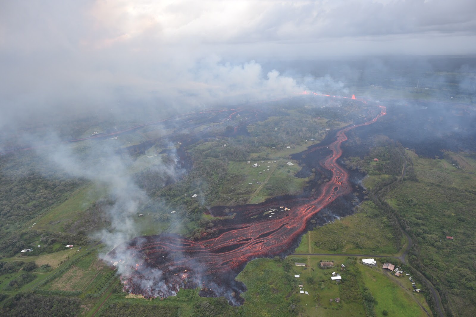 |
| May 19, 2018, 818am |
The system of fissures playing ma uka, that fountain, different braided streams, fume (bluish), smoke (whitish), those black things that look like islands - some may be accretionary balls - being rafted downstream. ABs are like snowballs, rolling and tumbling slowly as more and more lava adheres to their skin. They get bigger as they go. The fact that the channel is red, in daylight, all the way ma uka to the vents, is an indication of volume and speed. No time to crust over. Wow. This is NOT the flow down by MacKenzie. Look good, to the left of the big one, through the fume and smoke you can see another branch of the flow in the foreground. Guessing (and I may be wrong) that that skinny flow is the one by MacKenzie.

Above, a clumsy attempt at a comparison shot. Pohoiki Road is vertical curvy line at right. The metal roofs of burned buildings remain on black part of ʻaʻā.
Not much else to say right now. Pray for those displaced and threatened. Auē.
Pop in to the Hawaiian Volcano Observatory
and Hawaiʻi County Civil Defense websites to stay current.
As always, with aloha,
Bobby
No comments:
Post a Comment