Kaluapele

On the Island of Hawaiʻi, Kaluapele (the pit of pele or Pele) crowns the summit region of the volcano Kīlauea.

30 July 2018

Kīlauea Update, Monday, July 30, 2018, Taking time to remember...

In pre-sunrise glow, that time of alaula...that quiet time when itʻs cool and still, and when it can seem youʻre the only one in the world, when undistracted thinking is best...this is my favorite time of day.  

And I have the luxury of time to remember, because we seem, however briefly, to be in another oia mau nō phase of observing and waiting and wondering.  And Iʻm remembering my parents.  Today is Maʻs birthday, and Wednesday, Dadʻs.  Iʻm remembering how they sacrificed, taught, encouraged, and loved us.  And Iʻm recalling those times, growing up in Honokaʻa, when life truly was a much simpler, slower-paced time.  I remember.  And I thank both of them, because the foundation they laid is in large part responsible for who and what I am today...

And...The ʻōlai continue up here, rooster continues to crow, pele flows and Kaluapele subsides.  I shake my head with wonderment.  I have the luxury of time to muse, to scribble, to try to make sense of things beyond our ken.  Ultimately though, the answer to Why? is, usually, Because.  When she going stop?  When she stops. Yesterday, from USGS HVO:


In the meantime, we appreciate, enjoy, and marvel at the works of all who keep us informed.  We remember to thank all of them.  Though most media have moved on to other newsworthy events, here on Hawaiʻi nei, Pelehonuamea still erupts, homes continue to be lost (most recently by brushfire), and the lives of many are affected in ways those who are not here cannot comprehend.


As abstract as the Thermal Maps might appear, the information displayed is invaluable.  The hotter, the whiter.  Like having x-ray vision.  Whatʻs going on under all that clinker of ʻaʻā?  Under those blankets of steam and fume and smoke?  How, where, why, when will She travel?  Rubbly front of flow moves creakily, first here, then there.  "Kūlipeʻe", a word found in at least one chant of old aptly describes that motion as "To creep along, as a sick person; to stumble awkwardly along; to walk as though weak-kneed".  Maybe I relate because thatʻs how I often walk on uneven terrain these days.  Post-polio, you know...and though the walking is unsteady, good friends are my outriggers, and we go...and I am grateful for their aid.

And I going go...Other duties call, but Iʻll be back here later in the week.

As always, with aloha,

BobbyC
maniniowali@gmail.com

29 July 2018

Kīlauea Update, Sunday, July 29, 2018, PŪʻIWA!!!

Letʻs just cut to the chase, and start with this:


And, just because, here are links to the two photos on the HVO website:


Looking westward, the slope of Maunaloa rises.  The green wedge is pastureland in the ʻŌhaikea region of Kapāpala Ranch.  To the right of the green, the grey shows us the extent of ʻōhiʻa dieback in the forests of Keauhou, an ʻili (traditional unit of subdivision) of the ahupuaʻa of Kapāpala.  Nearly all of the big old ʻōhiʻa in Kīpukapuaulu in that area are dead, through natural processes pre-dating Rapid ʻŌhiʻa Death (ROD).  Iʻll write more about this at another time.
In both photos, you can zoom in and see the buildings of USGS Hawaiian Volcano Observatoryʻs Reginald T. Okamura Building, and the adjacent NPS Thomas A. Jaggar Museum perched near the rim of Kaluapele (the caldera of Kīlauea).  
At the bottom left of the bottom photo might be a remnant of Crater Rim Drive, the vertical linear section.  The Halemaʻumaʻu Parking Lot disappeared piecemeal into the abyss weeks ago.

On the USGS "Kīlauea Crater" topographic map below, the red segmented line running through the middle of Halemaʻumaʻu is the boundary between Kāpapala (on the left) and Keauhou (on the right), both in the District of Kaʻū.


And some may wonder:  Kaluapele?  Kīlauea Crater?  Kīlauea Caldera?  What???

Mr Kalama in 1837 drew a map, on which he labeled KaluaPele o Kilauea.  He was a student at Lahainaluna.


Kīlauea Crater is named that on the topo map because the US Board on Geographic Names, in their Geographic Names Information System (GNIS) database does not have "Caldera" as a descriptor.  The summit of Kīlauea is crowned by a caldera, sometimes defined as a crater more than a mile in diameter, so scientists and others use Kīlauea Caldera.  Above, the olive green denotes the district of Hilo, and red, Puna.  The current spelling of "Opihikau" is Opihikao.  "Mauna" = mountain.  "Kaik. o Waiakea" is Kaikūono o Waiākea, or Waiākea Bay, today called Hilo Bay or Kūhiō Bay, or....

And just to be clear, the KEcam photo below is of what I call the NE Bay, a newly collapsing area NE of Halemaʻumaʻu.  The corner of the roof of the HVO Observation tower points toward the dark face of the wall of Halemaʻumaʻu, just past the pale ash-covered kaulu (ledge).

Take your time, peruse, mull, consider, and allow yourself to be pūʻiwa...stupefied on account of wonder.  As NAP wrote me this morning, "Itʻs as if she were sucking in upon herself and spewing an ʻuwehe, ʻami and slide".


OK...Thisʻll be a busy week.  Lots of chores, errands, appointments, and life to live.  Iʻll likely post something brief in the morning, then not again till Thursday or Friday.  You should have the tools to poke around on your own, till then...

as always, with aloha,

BobbyC
maniniowali@gmail.com

28 July 2018

Kīlauea Update, Saturday, July 28, 2017, Variations: Significant or not?

And here we are.  Number Eighty.  No wonder I canʻt always remember what I said.  And if I repeat, I trust that the re-learning will re-inforce. 

Our blessed moaʻe (a generic for trade wind) have returned.  A couple things about that...During this time of the blooming of ʻawapuhi kāhili, or kāhili ginger, a nasty invasive imported from the Himalaya because of it beautiful inflorescences, I think that pollens are suspended in the air, and batches move about on breezes.  Across the street this morning:


You can maybe make out the recurved tips of the leaves.  White, yellow, and other ginger have flat leaves.

A bit of a geography refresher (thanks for asking, db)...Normal trades blow from the NE.  The bad vog came when winds shifted to the E.  Iʻm a little over 20 miles ESW of Keahialaka, source of tens of thousands of tons of SO2 daily.  And Iʻm a little over 4 miles ENE of Kaluapele, so we feel every little creak and groan taking place at the summit.


And another casualty of our serious bout of uahi ʻawa last Monday, leaves of my Punaluʻu hibiscus are falling off.  The vog lasted just a few hours, but damage was noticeable.  Not surprising, since Oʻahu hibiscuses didnʻt have to adapt to vog. 

TryRead about uahi ʻawa (vog):


Back to winds and ginger:  A problem is Iʻm allergic to kāhili ginger (so named because of its resemblance to feather standards), and when those batches of pollen-laden air waft my way, the sneezing begins.  And itʻs not only the sneezing.  Worse are the rhizomes (underground stems) of kāhili ginger that form thick knobby mats, prohibiting other plants from growing and choking those already present.  Up here in native rain forest that is NOT a good thing.  And kāhili ginger sets a lot of seed in pods that are bright orange when they split open.  


Birds eat the seed and distribute them far and wide.  Thankfully not much of this applies to ʻawapuhi keʻokeʻo (white ginger), my favorite.  Rhizomes arenʻt as thick, and the flowers donʻt seem to set seed.  And, the scent of white ginger is different and very pleasing.  To me.  And others, like kuʻuhoa hk, are very fond of ʻawapuhi melemele (yellow ginger). And, although theyʻre invasive too, the gingers with white flowers and yellow, as well as other varieties, arenʻt as invasively bad, in my of course very subjective and humble opinion.  And The Best white ginger is the one I saw in Waipiʻo decades ago.  We were walking on the path to Waimā, and in the middle of the "road" was a giant patch of what I now call Waimā ginger:  white with a bright yellow heart.  Different and beauty full.  I have one in my yard.

Side note of a tangential nature:  Spread out your right hand flat.  That looks like a plan-view of Waipiʻo.  Your thumb is Hiʻilawe, index finger Waimā, then Koʻiawe, Alakahi and Kawainui.  Five amphitheater-headed valleys in the back of Waipiʻo.  And at Kawainui is the Waimanu Gap, leading to that valley.  Eventually, because of headwall erosion, Waimanu and Kawainui will join.  Eventually.

And here are two Waipiʻo songs by Robi Kahakalau, evoking the loveliness of that place.  For a time, maybe in the late 70s, almost every weekend Iʻd walk down and cruise around.  Just because.  Fond memories.  "Alolua" is a really cool word.  One definition is "facing each other", as the pali do deep in the back of the valley.  Somebody told me one time that the best loʻi (wetland kalo patches) are in the front of the valley because they get the most sunlight.  Way back, Waipiʻo is so deep and narrow that hours of direct sunlight are diminished.

He Po Lani Makamae

Na Pali Alo Lua

And I forget the other thing about moaʻe I was going tell you...

So.  Down at Puna ma kai, She still going.  Though Pele seems to be contemplating her next moves, the Thermal Map shows us that sheʻs still very busy.


And I know I keep saying this, but no get cocky or sassy.  There were some that thought houses remaining on the north edge of the flow field were safe after the initial onslaught seemed to "stop" at Kapoho.  Then pele reactivated...  The kahawai pele (lava stream) is a complex thing, and stuff happens:  volume erupted, as we see below, fluctuates, lava bergs float down and create blockages, chunks of levee break off and cause blockages too, or gaps in the levee allow flows to move in new directions.  

There are pulses in volume of lava being erupted.  The following were taken by HVO over the course of four minutes a couple days ago:


And, while I was noodling around, watching the PG cam yesterday afternoon, I thought "Wow!  She stopped?".  Fifteen minutes later, when the next shot was posted:  "Oh...I see"...then again, and again.  Looks like longer duration and maybe more intense pulses.  Why?  Because...


And another repeat geographical note:  The kinda pointy puʻu directly behind F8 is Kaliʻu, a location sometimes mentioned in chant.

And trying to figure out the internal processes of Pele and her pele is interesting and sometimes challenging.  Cheryl Gansecki and gang at UH Hilo have been working to decipher geochemistry.  Lava samples are collected as close to molten as possible, then quenched (quickly cooled) in water to preserve crystal distribution and structure, because that changes during the natural cooling process.  Then samples are sliced super-thin and viewed under a microscope to see what minerals, and in what proportions, are present.

TryRead:

Volcano Watch 072718

And finally, because I forgot to include this days ago, hereʻs a link to information about those Wow! Lidar images of Halemaʻumaʻu.  Thanks to KE for sending it to me originally, and Ipo for the reminder in yesterdays Comments.  I may have forgotten because I havenʻt made time to figure out how to work the buttons to view the info.  Enjoy...

Pūʻiwa-inducing LIDAR images of Kīlauea

OK?  More in the morning... Enjoy the weekend.

As always, with aloha,

BobbyC
maniniowali@gmail.com

27 July 2018

Kīlauea Update, Friday, July 27, 2018. Subtle (or Suttle?) changes...

I needed a kickstart today.  Actually, it was a walkstart.  On the streets of the Golf Course subdivision.  The air was...hazy with an ever-so-tiny bit gritty on the tongue.  Masses of air blow hither and yon, there, then here, as wind directions change.  Trades are apparently deciding whether or not they want to be here.  And when they are here, the air is crisp and clean and clear.  Other times...I react with a hmmmmm.  Is this the exhalation of Pele from Keahialaka?  Suspended extremely fine wind-blown lehu (ash)?  A combination?  Then I inhale, testing...canʻt smell kūkaepele (sulphur)?  Then off we go a-rambling.

Might be, may be, vog (uahi ʻawa).  After being around it for decades, my telltale is Instant Headache.  At least up here.  On the west side of our fair isle, itʻs scratchy throat, dry eyes.  Whatever your symptoms... the closer you are to the source, the worse it is.  Though of course living in it, as folks in the Konas, Kaʻū, and Puna do, is challenging.  And thatʻs an understatement if there ever was one.  At least up here, kona winds blow in uahi ʻawa, and trades carry it away.  Lucky us.  TryRead:

what is Vog?

for a simple, straightforward explanation.

Next topicette:  English is odd sometimes.  Subtle.  Not Suttle.  Suttle, according to Wiktionary, is the weight of commodities after the container weight is deducted, and before weight of waste is deducted.  And Subtle (with its silent "b") is often misspelled Suttle.  Now we know.

And there are indeed subtle changes in the works of Pelehonuamea.  Now the kahawai pele is fast, then her river is slightly sluggish.  Her fountains are tall, then the luaʻi pele seems to abate.  Get plenny ʻōlaʻi, then not so much.  Her ʻaʻā moves fast, then slows, then stalls, then goes again.  We should all be as watchful as we can.  No get cocky.  Weʻre happy that Pohoiki ma kai is still OK.  At least we presume and hope that it is.  But we thought that of the Kumukahi-side of Beach Lots for awhile, then look what happened.  All gone.


Would be good if Pele spared Pohoiki.  Then all they gotta do (if, IF things remain as they are) is clean .7 (seven-tenths) of a mile of road by MacKenzie, and people can go from the ʻOpihikao-side.  Otherwise gotta investigate making Honolulu Landing again.  More about that later.

And there are subtle changes in the ʻōpelu outside.  Not the fish kind.  The plant one:  Lobelia hypoleuca.  Beauteous spikes of blue flowers in the Fall.  The tips of the branches are now narrow and tight, the indication that the inflorescence, the flowering branch is about to appear.  These photos are from seasons ago and arenʻt the best, but youʻll get the idea, I hope.


And up at Kaluapele, I suppose the big news was that the interval between the last two exploquakes was 53.5 hours.  That too, a subtle change?  Maybe not so subtle, maybe it means nothing other than we had another exploquake.  All I know is now, today, we are having lots of M3ish ʻōlaʻi.  Lots.  Every day is different.  And walking at the GC today, every once in awhile I felt dizzy.  Funny kine.  Like I was dehydrated and needed to drink water or something.  But not.

Today is shortish.  Sometimes even a walkstart doesnʻt quite do it.  But Iʻll be back tomorrow with more info for your consideration.

Till then as always, with aloha,

BobbyC

26 July 2018

Kīlauea Update, Thursday, July 26, 2018. ʻUpu aʻe ka manaʻo...

You know how sometimes a song gets stuck in your head?  Endless phraserepeat... Yesterday, it was "Aliʻipoe".  Even this morning...Itʻs one of those melodies I find so...so...attractive, so la-la-able, and when you singread the lyrics, ahhhhhh.  Like Ipo said yesterday, "Haku mele of earlier times certainly were poetic"...  Their sensibilities of course are from a different, a much different, era.  Those haku mele (composers) were able to capture feelings and express them in ways that make one (me) want to weep.  Like the lush harmonies of Hoʻokena and their rendition of Mī Nei.  And today, the young men of the trio Keauhou, and their versions of those old favorites.

Deep, deep, sigh..... And this was all triggered by a little editing I did yesterday for a friend, and they used the phrase "ʻUpu mai ana ke aloha...". 

From the P/E (Pukui & Elbert) Hawaiian Dictionary:

ʻupu
nvt. Recurring thought, desire, attachment, hope, expectation; to desire, long for, covet, keep thinking of with anticipation.

It fascinates me that a four letter word carries so much weight; means so much.  And is so lovely and complex. 

Here are the lyrics to "Aliʻipoe", and then a youtube link to my favorite version, by Nā Hoa.


Yes, a couple lines of the English translation are a bit clunky, but I trust that youʻll get the idea anyway.

And today (a segue...) the recurring thought...Upu aʻe ka manaʻo...What about Pohoiki?  And another...Whatʻs underfoot here at the summit?

The first is maybe easier to answer.  As of yesterday afternoon (WED 7/25/18) Pele was observing the boat ramp from just 500 feet away.  Her intentions are inscrutable as they always are, but we remain hopefully resigned (is that even a thing?!) to whatever she decides is best.  From a DLNR overflight yesterday:


And the Star Advertiser, yesterday too:


And we wait.  I just shut the windows.  The air is hauna because of uahi ʻawa, stench-filled because of sulphur smoke.  Had a BAD uahi ʻawa episode up here late Monday morning.  I was in town, and when I got home the house smelled funny kine, but I wasnʻt too concerned.  Weedeating on Tuesday, I noted shriveled dandelion leaves and the edges of some kīkā (cigar flower) leaves looked burnt.  By yesterday afternoon, all the kīkā leaves were fried, and the maʻo hau hele leaves too.  And weʻre 20 miles from Keahialaka!  Interestingly, the hāpuʻu, ʻōlapa, and all other forest friends are fine.  Theyʻve adapted.

And we wait.  No exploquake for 48 hours.  Should I be concerned?  TryLook at the Tilt:


This is Two Days at Uēkahuna, by HVO and Jaggar.  Sure looks like itʻs moderating or flattening.  But what do I know???  The offset in the graph happened right around 4p yesterday.  I was minding my own business here in the loft working on something or other.  Shake shake shake...  I wrote:  "3 or 4 distinct shakes in ~1 min".  Turned out to be a slightly skewed version of reality.

Was at 3:55.55pm, a M3.6; at 3:57.16p, a M3.6; and at 3:57.46p, a M3.9.  Thoughts flashed to "Is this it?  Are we sinking?"  Then a quick look and rewind of the VolcanoHouse Live cam:


Pretty big rockfalls and what-la.  But.  No "5.3 No Tsunami Generated" message.  Still waiting.  And I donʻt know if I should be concerned.  Is something stuck?  Have we entered a new phase?  Remember what I said about being complacent and not predicting patterns?  Just gotta wait and see what She has in store for us.  Bobby reminding Bobby to breathe...

Because with all the instruments and fancy equipment and all the data being collected, analyzed and reviewed, and every little thing we sense and/or feel, No One Has A Clue.  Yes, we can see what happened, or whatʻs happening Right Now; but 5 seconds from now, tomorrow, next week or next year???  Who knows???

So we walk when we can, maybe go for a swim or bob (ahhhh Kikaua, hk), and we listen to lovely, evocative music, with gratitude to the musicians for their artistry and skill.

ʻUpu aʻe ka manaʻo....

As always, with aloha,

BobbyC

25 July 2018

Kīlauea Update, Wednesday, July 25, 2018, Dipping in a toe...

What amazing times these are.  On many levels.  Mind-boggling, perplexing, heart wrenching, devastating, stupefying, inspiring, and most of all...sobering.  We Are Not In Charge.  We perhaps like to think we are, but we arenʻt.  On some level I believe we all understand that.  And so we often pray, many of us, to various gods, deities, beings; seeking consolation and hoping to understand...Why?

Ultimately, we are here, all of us, for the shortest of times.  We strive to live good lives and leave legacies of good works.  At least we should.  Not much else matters.  

We quibble over naming the Fissure, the Puʻu, the Channel, the Point, the Bay, the Pond.  Names are indeed important.  They are records and reminders.  Is it Pelehonuamea?  Is it ʻAilāʻau? Gentle and Feminine?  Brutal and Masculine?  God or god?  Us or Them?

We seem to have lost the ability to have civil, thoughtful discourse.  Good-natured talk story sessions where information is freely shared, ideas (no matter how outlandish) discussed, and consensus reached.  Give and take.  Open to learning, the joys of discovery, and those big or little ah-HAH! moments.  We should all have convictions and points-of-view, but those should be based on objective rather than subjective thoughts and ideas.  "Should" is the operative word.  Too often emotions and passions interfere and lead us astray.  

Especially in these tender-hearted times, when emotions are raw and grief sometimes elusive, we all need to take a breath...Just breathe.  Go for a walk.  Go swim.  Enjoy ono food.

And while breathing, consider options.  Consider differing points of view.  Consider the foibles of humanity.  Just consider.  Be considerate.  Please.

And we wait.  And watch.  And agonize.  As of this morning, HVO tweeted that the boat ramp at Pohoiki is still there.  They provided a couple photos.  We wait...and appreciate beauty.  And sadness.


And up here we wait too, not too obsessively, I hope, for the next exploquake.  Note that Magnitude data for those events take awhile to be examined and processed by Seismologists.  Numbers, especially for larger ʻōlaʻi, seem often to be lower after they are studied.  What was a M5.6 yesterday is now (another) M5.3.

And while waiting we putter, do chores, go walk (ahhhh "Retirement!")... And too, of course, we read, research, write.  And sometimes watch videos.

Exploquake Video, July 24, 2018, 640ish Antemeridian

The caption for the video by HVO:

A collapse event occurred at the summit of Kīlauea this morning (July 24, 2018) at 6:41 a.m. HST, releasing energy equivalent to a magnitude-5.3 earthquake, which is similar to that released by previous collapse events. In this video, watch as today's event unfolds from the perspective of HVO's live-stream camera. At 6:41:08 (time stamp at upper left), a small tree along the right margin of the video begins to sway. At 6:41:10, a pressure wave passes through the steam plume in the crater, and light is reflected back to the camera (highlights the passage of the expanding sound energy through the air. At 6:41:11, a rockfall begins on the South Sulphur Banks, a distant light-colored scarp on the left.

Below, a graphic tweeted by HVO.


Maybe itʻll help you visualize inside.  Of course itʻs an approximation of what scientists think might be beneath our feet.

Note that the horizontal East Rift zone yellow ends, above, at Puʻuʻōʻō.  Extend mentally to nearly Kapoho Crater, please.  10km deep = 6.2 miles = 32,800 feet.

"Basal decollement" is where the base of Kīlauea sits on the oceanic crust.  More or less.

be outside...pay attention       noho i waho...a maliu

I going walk...

As always, with aloha,

BobbyC

24 July 2018

Kīlauea Update, Tuesday, July 24, 2018. Pick one, any one...Halemaʻumaʻu

So many topics to choose from.  Thatʻs the hardest part for me, especially since these scribblings are not meant to be a magnum opus.  Although, I suppose one could argue that after 75+ it might be turning into one.

And then I still wrestle with:  I need to write. I should be writing.  I feel guilty for not writing.  And on it goes.  But I did manage to have fun, productive, inspiring time off this past weekend, so that has to count for something too.

It seems that these Posts are evolving.  Or rather, my attitude about them is.  My brain is full of all sorts of information about our natural and cultural history.  I could prattle on for hours and pages about topics of interest to me (and I trust to you), but there has to be, I know, limits.  We shall see where this all goes.  And another reminder:  If thereʻs something, a topic or whatever, youʻd like me to share about, just ask me at:

maniniowali@gmail.com

At Pohoiki, on the coast of Puna ma kai, Pele is in the neighborhood, but as of 7a this morning or so, the boat ramp, Hale family home, and those kamani trees, etc., are all still there.  Just gotta wait and see.  And yes, thatʻs exceedingly frustrating to do.  Wait...


Yesterdays Flow Map, with stats...And because for now the ocean entry is on the south end of the delta, Kumukahi remains the place where Hawaiʻi greets the rising of the sun.


But with F8, Fissure 8, Māwae ʻEwalu (pick one), still going, all we can do is wait, hope, pray, and always remember that we arenʻt in charge here.

The Media have mostly moved on to other issues, though of course for us, what could be more important?

And, importantly for those of us in Volcano neighborhoods, what, oh what, is happening in Kaluapele?  Will the highway stop cracking?  Will the floor of Kaluapele stop subsiding?  Will ʻōlaʻi and exploquakes stop?  Will the Park reopen?  Will visitors return?  Yes.

Note that in the above, "When?", is noticeably absent.  The following was posted before, but it bears repeating:

USGS HVO Summit Scenarios, July 5, 2018

I just happened to be at my desk for this mornings exploquake at 641a, equivalent magnitude of 5.6.  The puffs of yellowish rockfall dust at the left come from the previously buried South Sulphur Bank:


The South Sulphur Bank:


Above, on July 22, 2018, the flat grey area above the South Sulphur Bank is the September 1982 flow.  Keen eyes can barely make out Crater Rim Drive as the horizontal line crossing it from the tan floor on the right.

HVO caption:

"Collapse of Kīlaueaʻs caldera floor has exposed South Sulphur Bank, prominent in the mid-19th century but covered as lava flows filled the caldera.  The flat top of the white deposit shows how high the caldera fill reached.  As the caldera floor dropped in mid-June 2018, South Sulphur Bank was again exposed.  The height of the bank, now more than 65m (213 ft), increases about 2.5m (9 ft) with each collapse event at Kilaueaʻs summit.  On the caldera floor, white patches lie along spatter ramparts formed in 1971 and 1974."

Now, as part of our ongoing Educational Outreach Program, weʻll visit part of the State Department of Accounting and General Services website:

DAGS Map Search

Download the Registered Map Index, peruse, and type in a Registered Map No. of interest in the "Search" box.  CAUTION:  This activity may prove to be highly addictive.

The map below is RegMap1273, by Frank Dodge, August 1886.  Lots of information on these old maps.  Note "Sulphur banks" at the top, and "Old Sulphur Beds" at the bottom.  the latter are part of the white cliffs on the photo above, and lie under the 1971 and 1974 flows.

Also above, the dark blob at the lower right of Kaluapele is the crater, Keanakākoʻi.  And of course, note the shape of Halemaʻumaʻu back then.  Hereʻs another map by Dodge depicting the changes in Halemaʻumaʻu between March 1886 and October 1892.  

Change.  Changes.  Changing.  Changed.

And if we go back even further in time, when Malden was visiting Kilauea in 1825.  First his map:


Then a blowup of the References at upper left of the map.  "8. The Black Ledge..." was a noted feature in those times, and appears perhaps to have been a bathtub ring on the walls of Kaluapele.


And, a note about that "Hut" on the Plain between Kaluapele and Kilauea Iki:

OK then...I trust that all is legible and informative.  And because I canʻt help myself, hereʻs the KEcam image of 1030a today.  When you zoom in, note the pali forming to the left of the recently formed pali and kaulu (ledge) on the east edge of Halemaʻumaʻu.  And the white pali at the right is the same one pictured above.  


Iʻll be here again tomorrow.

As always, with aloha,

BobbyC

21 July 2018

Kīlauea Update, Saturday, July 21, 2018. It is really just all about the numbers?

Another relatively quiet morning here at Keaʻau ma uka.  Calm winds...just enough for lau ʻōlapa outside to do their kapalili (trembling) thing...and, (mostly) calm ground.  I seem to have developed the knack of being able to sleep through ʻōlaʻi in the mid-M3 range.  Slept all night, felt nothing.  Gotta wonder:  Is that good??

I sense, despite the clusters of ʻōlaʻi now and again, that Pelehonuamea and siblings are a tiny bit calmer.  Calm.  Is my repeating that word a mantra of sorts?  Mayhaps.  But then we see the Tilt for the last two days.  The instrument is in an underground vault near HVO and Uēkahuna:


Does it seem to you that the curve is flattening?  Even just a tiny bit?  It does to me.  But then I wonder about malfunctioning instruments.  I wonder, after more than two months, can that really be so?  I wonder, what if...And when I start wondering that, I consciously stop.  Because what good does it do?  To wonder?  Especially about that.

We observe, and in observing, we wonder.  The thing is, wondering is part of the curiosity of it all.  How are we to make sense of anything if we canʻt wonder?  Especially because, lacking x-ray vision or some magical insight, all we really have are instruments and observations and wonder, guiding us to some understanding of the workings of Pelehonuamea mā.  Pieces of the puzzle are slowly assembled, and while doing that we think and wonder.

OK.  Nuff with the Wonder.  Here, then, are some numbers extracted from the HVO Cooperator Report to Hawaiʻi County Civil Defense, of July 15, 2018.

Fissure 8 was born on May 5, 2018.  It wasnʻt till May 28 that Pele settled in and began her prolonged residence there.
The puʻu she built is 180 feet tall.
The estimated flux (amount of pele erupted) is 100 cubic meters per second.  Or 3,530 cubic feet per second, or 26,400 gallons per second...
Her māwae pele (lava channel) is 8 miles long, from the vent to where she debouches into the Pacific.
The ma uka 2.5 miles or so of the māwae sits 53 to 72 feet above the original ground surface.
In places, the braided māwae is 1,300 feet wide.
The amount of uahi ʻawa (SO2) being emitted at Keahialaka is more than 30,000 metric tons per day.  Four times the amount emitted from the lake in Halemaʻumaʻu.
At the coast, muliwai a Pele (the lava delta) is 3.7 miles wide and in places extends a half mile out from the original shoreline.
Hydrovolcanic explosions (water+lava) occur up to 325 feet offshore.

Wonder and think about the numbers presented above.

As of yesterday, pele paused about a quarter mile from the boat ramp at Pohoiki and Isaac Hale (huh-leh) Park.  The red house is the Hale family home.  The hump below [Take Pohoiki] is Waiapele (Kapoho Crater).  And some of the trees along the shore are old, gnarled kamani.  A favorite for the shimmery scintillating grain of its wood.


Yesterday, from HVO, A Scene, Just after Sunrise.  On the horizon:  Maunaloa and Maunakea...Looks like one of those old "Volcano School" paintings by Hitchcock or somebody.


And this morning, at Kaluapele, the vapors of hanging clouds and rising māhu (steam) intertwine and mingle.  


If we take time to be outside and pay attention (or if cannot, we nānā...look...at images), we see that despite calamity, worry, and fretting, There is Beauty All Around Us.

As always, with aloha,

BobbyC
maniniowali@gmail.com

20 July 2018

Kīlauea Update, Friday, July 20, 2018, Part the Second.

Our friends at the USGS Hawaiian Volcano Observatory have published A Report:


Preliminary Analysis of the ongoing Lower East Rift Zone (LERZ)


eruption of Kīlauea Volcano:  Fissure 8 Prognosis and Ongoing Hazards

USGS Report, July 15, 2018, Preliminary Analysis: LERZ

It deserves to be read thoughtfully and with care, so take your time.

Till tomorrow,

BobbyC

Kīlauea Update, Friday, July 20, 2018. The Moon and who was ʻAilāʻau?

in 1969:  The Apollo program:  Apollo 11ʻs crew successfully makes the first manned landing on the Moon in the Sea of Tranquility.  Americans Neil Armstrong and Buzz Aldrin become the first humans to walk on the moon six and a half hours later.

I remember that day, partly because it was also Grampa Rapozo's birthday.  And today at 6a, I was washing last nights dishes.  I know...when I grew up, pau eat, had to wash wipe and put away the dishes.  But when I designed my house in 84, I made an eight foot wide three foot tall window over the kitchen counter so I could look outside when washing dishes.  And because itʻs cool up here at nearly 4,000 feet, no mo too many bugs.  Roaches are extremely rare, and though they sometimes travel up in packages from Hilo.  Kill um when you see um.  So far, ants too are rare, but gotta be vigilant.  No termites.  Alas no geckoes (used to love to hear them chirping at Puakō).  Sooooo....I can leave the dishes overnight without too much fear of feeding vermin.  And I get to check in on the sky and the wind and the clouds, and today

hapuu stipes vee
cool still morning air welcomes
rising of the sun

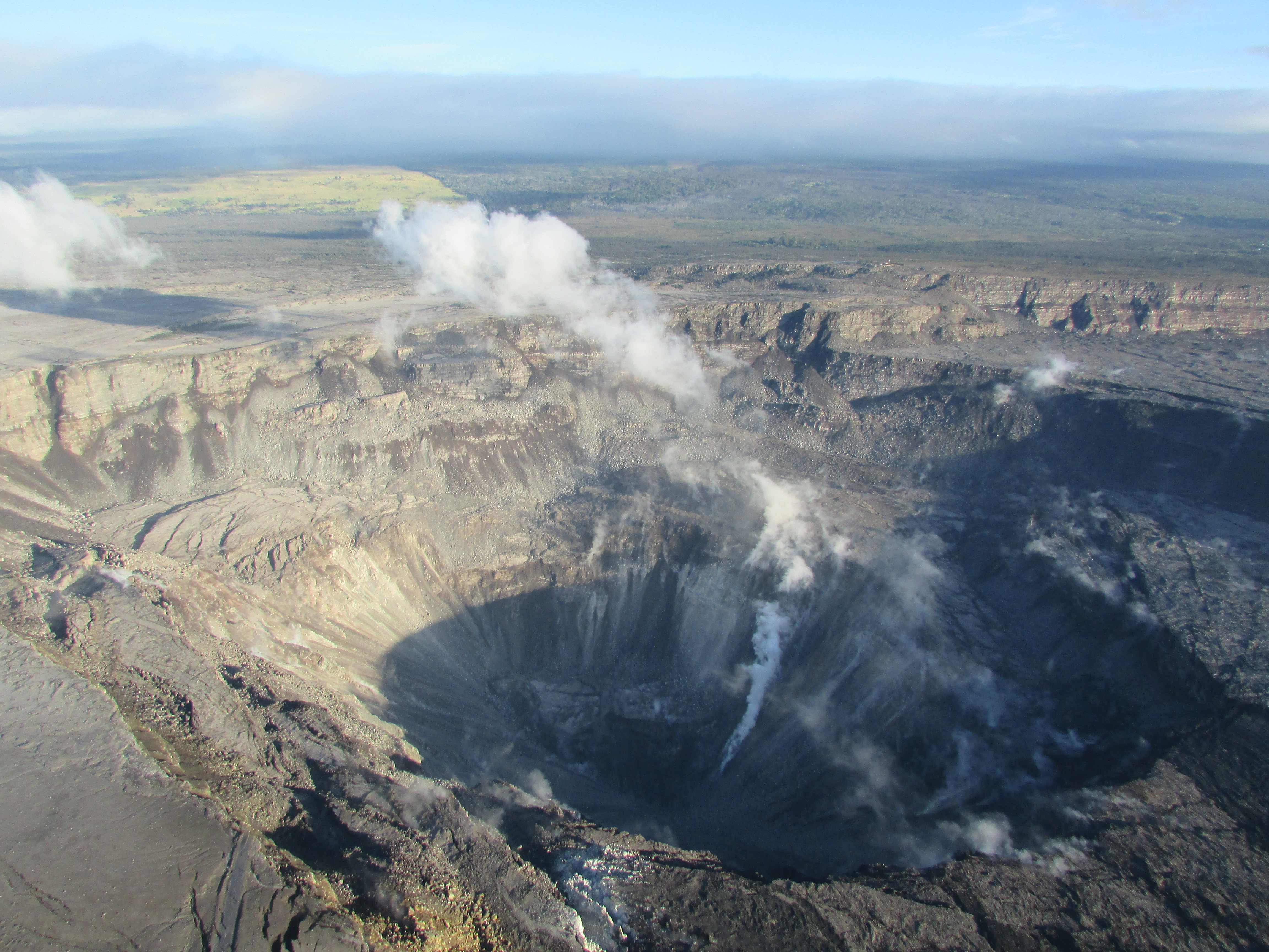
Itʻs pretty much oia mau nō (things as usual) both up here in the summit region, and at Puna ma kai (except for the oozing toward Pohoiki!).  Great KEcam pic at 6a of Kaluapele:


Yes, the M5.3 or so exploquakes continue.  The last several have happened every 35 hours or so:  33, 44, 32, 32, 38, 39... Yesterdays was at 433p, so the night was a restful one, both psychologically and physically.  And the main highway, between the 28 and 30 mile markers near the entrance to the Volcano Golf Course, continues to crack and twist.  That section is built on fill that is apparently being shaken and is settling during our numerous ʻōlaʻi.  

Go Slow!!!  25mph Speed Limit signs have been posted.  
I know most of us ignore speed limits, but this time the road is falling apart 
(mahalo to State and County crews for repair work), so drive with care:

be outside...pay attention    noho i waho...a maliu

And yes, Kaluapele continues to subside.  My gauge these days are the cracks to the left of the new pali on the floor.  Go look at the KEcam:


at Puna ma kai:

Yesterday, though the main ocean entry was mid-delta, pele continued to creep toward Pohoiki and Isaac Hale Park.  Thatʻs Hale (huh-leh) as in "house".  Not to be confused with Hale as in "Hale and Hearty", as some are.

Deep sigh...


So about ʻAilāʻau...Iʻve heard from folks that some think ʻAilāʻau is responsible for the current activity in Keahialaka.  Hereʻs something Westervelt wrote in 1916 in "Hawaiian Legends of Volcanoes".  Maybe you have it?  The small book.  Or you can google if the text is too small to read.


ʻAilāʻau lived, as the story goes, in Kīlauea Iki.  Geologist Robin Holcomb, who mapped pele here in the 1970s, named a voluminous series of flows that issued from a vent at the east end of Kīlauea Iki, the ʻAilāʻau Flows.  First below is part (again) of the Neal & Lockwood map of the summit region:


Nāhuku (Thurston Lava Tube) is part of those flows, here in purple.  You can see, I hope, the concentric topographic contours (close where steep, farther apart where flat) nearly encircling Kīlauea Iki.  They mark the summit area of Holcombʻs ʻAilāʻau Shield.

Then part of the Edward W. Wolfe and Jean Morris compilation opus, the USGS "Geologic Map of the Island of Hawaiʻi", Map I-2524-A, printed in 1996:


Here, the ʻAilāʻau Flows are in white-lined pink, and keen eyes can see they originate at the east end of Kīlauea Iki.  While the bulk of those flows traveled northeast 40 miles or so to the Pacific, a small branch went south to ʻĀpua point in the park.  The flows to the north without the white lines belong to Maunaloa.

The ʻAilāʻau flows were active approximately from 1400 to 1475.  A lava tube named Kazumura extends nearly the entire length of the flow field,and has been mapped to just shy of the noticeably protruding Kaloli point, at the NW edge of the dense Hawaiian Paradise Park subdivision.  So yes, the vast majority of ALL the subdivisions in Puna (all those grey lines) are on flows just 500+ years old.

Then below, a closeup of the LERZ (Lower East Rift Zone):


And below, a Key to Ages. "Age ka" is Age in thousands of years.  So the p4y flows in the ahupuaʻa of Keahialaka, just SW of Pohoiki, are 200 to 400 years old, younger than those of ʻAilāʻau. Those are, if we believe the "stories", what Pelehonuamea made when she first arrived.  After ʻAilāʻau was pau with his work.  "Stories" in quotes, because I believe myths, legends, stories all relate actual events.


How you know?  How you know how old?  How you know when?  How you know???

Capable, diligent, exacting field geologists walk, hike, tramp, sometimes tumble, all over the place.  They are outside, paying attention, observing minute details of lava flow morphology, flow color, vegetation types, exposures, etc., in the field.  They look for subtle differences and clues.  They probe under the edges of flows, or between flows exposed on faults, the walls of craters or of gulches, and they look for charcoal.  When found, that charcoal is carefully collected and analyzed and C14 (an isotope of carbon) dates determined.  The charcoal likely formed when vegetation was burned by, and then preserved under, pele.  So the C14 date of the charcoal approximates the date of the overlying flow.  Technology has its limits, and so we see ranges of ages.  And as technologies improve, charcoal samples may get reanalyzed and dates may get refined.

And weʻll leave you with a bittersweet record of events as they have happened...


memories aswirl
laughter kai wai cool and warm
as Pele travels

As always, with aloha,

BobbyC