Kaluapele

On the Island of Hawaiʻi, Kaluapele (the pit of pele or Pele) crowns the summit region of the volcano Kīlauea.

19 June 2018

Kīlauea Update, Tuesday, June 19, 2018, Complacent? Hope not!!!

Hūi!

And the sunʻs up.  That golden light, filtered through noe uahi.  I have a sundial in my hale.  A window, high on the living room wall, above the front door.  Sun comes up, shadows are cast.  In case we forget what season weʻre in, the edge of the windowshadow is a guide.  And that sunrise shadow thing may stem from going early Mass when I was small.  I would watch the shadow move across the statued altar-wall of Our Lady of Lourdes in Honokaʻa.  Maybe I was bored because I couldnʻt understand Latin.  Remember?

Yesterday was a BobbyFavorite in ma uka ahupuaʻa Keaʻau.  Hot.  Sunny.  Clear.  Hang clothes on the line outside and they dry.  Crisp, kinda scratchy. Perfect.  Plus no moʻ fabric softener smell.  Hate that stuff.  Clouds gathered in the afternoon, darkening the summit region.

And on days like that, in our own little worlds, itʻs kinda easy to forget whatʻs going on just a few miles away.  We need days like yesterday to help us unwind.  And when the lehu seems to be diminishing, and the ʻōlaʻi fewer and less shaky, we think...pau?  Almost pau? Hmmmm... the big red dot = M5.3 exploquake at 505 this morning:


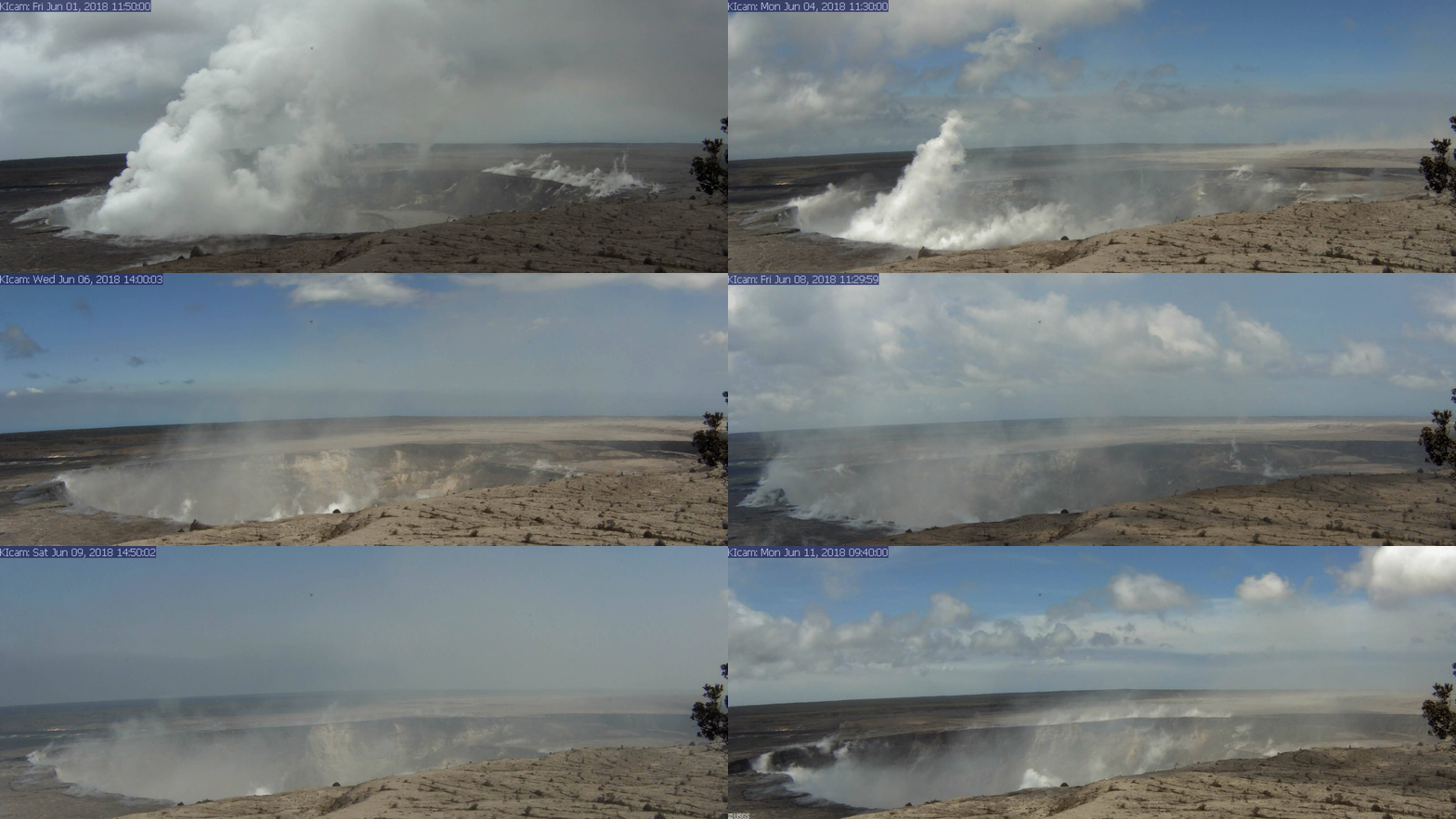
And then we revisit webcams, see that Keahialaka is still aflame, see that the ground around Jaggar Museum and HVO (Hawaiian Volcano Observatory) is still that odd pale greytan color, feel the shaking, breathe the hauna air in places, and we know...not pau.


Thisʻll be a tidying up session of random bits, noted but most not previously posted, I think...

Walking at the Volcano Golf Course yesterday was excellent.  And though the sky was mostly clear, the vogash blanketed part of Kapāpala on the slope of Mauna Loa.  Remember the puhiohio lehu on the floor of Kaluapele - the caldera?  They, and regular winds, pick up the finest of lehu, and that babypowder ash remains suspended in the air for...how long, I wonder.  Itʻs like when get booming BIG surfs and clouds of ʻehu kai, that salty mist of crashing waves, are suspended over the shore.  Makes everything sticky and your glasses fuzzy, but those inconveniences are way worth the sight:

Haki nuʻanuʻa mai ka nalu mai kahiki

Heavily breaks the surf from Kahiki 

The above, in Fornander, is a line from the Prayer of Malaehaakoa, in The Legend of Hiiakaikapoliopele.  Long long time ago, I think Hālau o Kekuhi and Sig collaborated on tee shirts, and I recall (I hope correctly) that Noe cut a design, captioned as above.

And why I went down that side street, who knows???  Maybe because the ʻehu kai stirred a memory.  And plus I still have the tee shirt.

The lehu-coated kaulu at Uēkahuna outside Jaggar Museum, steamy mists, leaden sky, yesterday afternoon:


Topic Change

Some wonder, Why on earth did "they" allow people to build homes on the most active rift zone of the most active volcano on earth?

good article in Civil Beat, Honolulu

And another interesting read on the topic is "Land and Power in Hawaii" by George Cooper and Gavan Daws.

Thousands upon thousands of houselots are on the Island of Hawaiʻi.  The majority, I would guess, are in areas of Lava-Flow Hazard Zones 1-3, as depicted below.  Many lots are without utilities, including County water, roads are "substandard", many unpaved, and many many folks are perfectly happy with those conditions.  All of us in Volcano do not have County water service.  The water line stops down the hill at Oshiro Road, between Mountain View and Glenwood.

Plenty lots + few or no services = relatively Cheap Land


None of this is secret, but there are some who get caught up in the romance of living in Hawaiʻi, and disregard realities, donʻt do adequate research, and donʻt really understand what theyʻre getting into.  Such is life.    

And our lives continue.  Native Hawaiians have lived with Pelehonuamea and her pele for centuries.  They too watched beloved landscapes altered, and entirely new ones created.  They too had communities, agricultural lands, shorelines and beaches, fish ponds, trail networks, forests, and wahi pana (legendary places) buried, while others were created.  In the 1400ʻs, in Puna, an eruption and lava flows lasted 75 years or so.  Starting near todays Kīlauea iki, flows made their way all the way down through the ahupuaʻa of Keaʻau, to the sea, and created a delta at Hawaiian Paradise Park and neighboring communities.  Ka lae Kaloli (Kaloli Point) is the terminus of a 40-mile-long lava tube active during those years.     

Don Swanson, a volcanologist at the Hawaiian Volcano Observatory, and one of my mentors, has written edifying papers, tying together the science of that eruption and centuries of periodic explosive activity that followed, and Native Hawaiian traditions.  The "Legends and Myths" of Pele and Hiʻiaka mā, are real.  They arenʻt fairy tales or mere stories.  Give these a read and see what you think.  Please let me know if the links DONʻT work:


OK?  Thatʻll keep you busy for awhile.  Busy week for me...Check out, if you can, the Hula Conference being held in Hilo this week:


As always, with aloha,

BobbyC
maniniowali@gmail.com

18 June 2018

Kīlauea Update, Monday, June 18, 2018, Yesterday: Clear afternoon at Kaluapele

So.  I did something bad yesterday.  (With sincere apologies to pn and dg)...  Most Sundays Iʻm on a conference call, helping edit a book.  Two hours.  With all the what-la hoop-la going on up here, I get distracted.  And itʻs NOT that the reading and commenting are boring.  Far from it.  Itʻs just that when you look Live Stream Full Screen at Halemaʻumaʻu, sometimes cannot help. I know I posted this before:

Live Stream Halemaʻumaʻu

and it looks like this


To see it Full Screen on your monitor click on the square broken-edged box at bottom right, just below the red bar.  (E.  Some people nono how.  Be nice.)

Returning to my original train of thought... I was glancing at first, then at times watching intently, because was so clear the weather: 


Just before I did the screen shot above, I watched not one, but several koaʻe flying around, checking things out, and some even landing on that dark broken shard of kaulu at the lower left.  Crazy.  Koaʻe are long-tailed tropic birds.  They nest on pali (cliffs) and feed at sea.  Theyʻve lived at Kaluapele for how long...and in crannies on Puʻupuaʻi at Kīlauea iki too.  Their long tail feathers were used to fashion some kāhili, the feathered standards of the aliʻi.

Hāmākua, the district on this island, kuʻu one hānau, is noted in song:

Hāmākua, i nā pali, i nā pali lele koaʻe

The pali in Hāmākua, the pali where koaʻe soar

If you be outside...pay attention, youʻll see them soaring erratically playfully, their white bodies contrasting beautifully with the sapphire of ocean under the lovely blue of sky or the other way around...but... I diverge, tangentially.  Again...

How can one NOT be distracted by all of this.  And if ʻōlaʻi, many many a day is the price of admission...

And then...because sometimes meteorological conditions are just right, we have ash storms and puahiohio lehu (ash-laden whirlwinds).  Above pic, right hand edge.

And a very similar phenomenon, one we saw with regularity at the coast as vigorous plumes of hydrochloric acid-laden steam rose from the shore at lava entry points, and temperature gradients and winds were just right, were slow moving funnels of steam hanging from the plume...  Kind of, but not quite like the one below yesterday morning, with the wispy bearded man peering in, arm extended upwards...


DANGER!!! Absolutely mesmerizing!  Who needs NetFlix?  Well, at night, maybe, because when the light goes out the camera goes dark.

And this morning, still abed, deciding whether or not to get cracking, She encourages with gentle shakingrolling...Upstairs I dash (well...lumber is more like it these days) to look:


The relatively gentle, uniquely moving, wakeup exploquake was about 613a.  And I must note, of late, the beauteousness of the billows.  Lehu-poor, guessing lots of steam and gases.  When we walk at the Golf Course, the winds seem to carry extremely fine, EXTREMELY fine tongue-coating ash.  And itʻs an eye irritant too.  I breathe with mouth slightly agape when I walk.  Thatʻs why.

So itʻs one of those beautiful things with obscured hazards.  Or something.

And yes, down at Keahialaka, still She works.  No day off.  Fountains yesterday, according to USGS HVO pulsed between 60 and 165 feet.  And She still is making the island bigger. And the PGcam too is mesmerizing.  Winds shift, light changes.  Early morning offshore breezes, because....Night time the land cools relative to the sea and winds blow down the mountain, out to sea.  Day time, land heats up and wind blows from the sea to the mountain, carrying moisture that condenses as the air rises forming clouds from which rain falls over ma uka slopes.  Diurnal heating and cooling.  Unless you have pyro-cumulus near the lava entry.  Billowing steam clouds rise high enough, form puffy cumulus clouds = rain.  From Pele.


And itʻs sad, in morninglight especially, to see the trees, most leafless, maybe dead or dying.  We hope maybe their leaves just fell off, and theyʻll resprout after the air is cleansed.  And the thinning vegetations allows us a peek at the left, of the green metal pipings at Puna Geothermal Venture (PGV).

And a visual from yesterday.  Out the kitchen window.  ʻŌpelu, and behind it the ʻōhelo kaulaʻau where mejiro play.  The brown things on the branch are last seasons seed pods.


And lest we forget, this below, taken at Halemaʻumaʻu in December 2005, by pal Alan Cressler.  Google him at Flickr for photos that are a constant source of amazement.

Note that this, of course, is before the lua in Halemaʻumaʻu opened in March 2008.  And thatʻs the swell of Mauna Loa in the background.  "Haze" at left horizon is noe uahi Puʻuʻōʻō (vog).


Well then.  No confetti today.  ʻŌlaʻi continue apace, breezy trades blow, sun shines. And I going walking!

As always, with aloha,

BobbyC

17 June 2018

Kīlauea Update, Sunday, June 17, 2018, Breezeless, but ʻōpelu tremble

opelu tremble
crisp breezeless morning sunkissed
there she rises too

A beaut of a morning in the forest.  Attempting an earlyish post so I can deal with housekeeping, long neglected.  Auē.  The mess!

Had a few ʻōlaʻi starting at 3am-ish.  If had some earlier, I was sleeping.  After 3, was that in-and-out of dreamland thing...  Out of bed just after sunrise, getting coffee ready, washing dishes, then heard the tinkling of pans hanging from the rack.  And out the kitchen window, ʻōpelu were swaying breezelessly.  Ah Hah!  She snuck in kinda quietly this morning.  Came upstairs and watched lehu rise up on the Halemaʻumaʻu Live Cam.  Mesmerizing.

Halemaʻumaʻu Live Cam

Oh.  And not the fish kine ʻōpelu; the plant one.  Lobelia hypoleuca.  Kinda junk, the picture, but the leaves are narrow and long, and whitish silver on the back.  Like ʻopelu the fish.  Not sure if this pairing is mentioned, like so many others, in the Kumulipo, but the plant is a favorite.  Thanks ZT.  And they not blooming now.  Wait till Fall.


Where was I???

Oh.  The lehu rising:


Remember the BIG lehu on May 15?  Gnarly blackness roiling.  By comparison, this is lovely.  But see that bit on the far right wall?  Hmmmm


Above, taken after most of the air cleared this morning.  But look at what I call a hanging slab, with māhu (steam) rising from the back, on the far wall.  Wonder how long thatʻll be there?  It probably carries with it part of the Halemaʻumaʻu Parking Lot.  Pele cleaning house.

And when it falls, it wonʻt do so silently.  When we look at pictures or video, theyʻre actually an abstraction of reality.  No sound, no smell, no heat.  I still, after decades, recall the scent of active pāhoehoe:  metallic.  Kind of like the taste when you lick a penny.  Go.  Try.  That, with a little sweetish methane mixed in.  And the sounds too are familiar but foreign.  The scraping of a lobe of pāhoehoe as it moves over an older flow.  The popping of chips off the surface as a brand new silvery flow contracts when cooling or expands when inflating.  The tumbling scraping of a front of ʻaʻā.  The crystal-tinkle of barely warm bits of pōhāhā (tephra or ejecta) falling and shattering around you.


Every.  Little.   Slump.
Quaking.  Tumbling.  She.  Settles.
Kaluapele.

thanks, hf, for the inspiration

And we can only imagine the soundnoise.  Rest assured she isnʻt silent.  Like watching a video, with sound muted, of raging surf.  We know itʻs noisy, but we canʻt hear it.  The rubble piles and fresh kaulu (ledges) in the lua (pit) donʻt just happen without sound effects.  Though yes, her lehu does rise more or less eerily silently.  We can only imagine the rumblings and clatterings.  And read, perhaps, Emersonʻs "Pele and Hiʻiaka" for some very descriptive prose.  Especially the "Hulihia" chants toward the back.  What a commotion!

Sure hope this link works:

Emerson: Pele and Hiʻiaka

And I think of "places" mentioned.  Puuonioni and Papalauahi.  No diacriticals used, because depending if theyʻre used or not, meaning changes.  Explore the Hawaiian Dictionary.  Ledges sticking out, move, squirm, stir, wiggle; being destroyed by lava flow, plates of fire, etc.  Those two places at the summit of Kīlauea are spoken of, I believe, as poetic references, rather than actual "places".  This is a time to muse, mull and wonder.  Be enthralled, fascinated, awestruck and yes, even a little scared.  And write down your thoughts and observations!  I know you probably not going, but...try...

Iʻm including this from Kihei DeSilva.  I appreciate his compilation, thinking and analyses:

A ka luna o Puuonioni

And of course the confetti, with that oddly placed red dot.  A reminder that all layers of the Island of Hawaiʻi are interconnected.  While Ka Wahine (The Woman) is busy at Kīlauea, Mauna Loa and her other edifices also tremble.  Note the lack of Red, and very little Orange and Yellow on the LERZ (Lower East Rift Zone).  Relatively quiet there on the ʻōlaʻi front.


And, at Puna ma kai, in Keahialaka, the erupting Māwae ʻEwalu (Fissure 8) still going.  The puʻu is about 175 feet tall, as is seemingly, her fountain.  And I keep forgetting...directly behind her, partly obscured by uahi ʻawa (sulphur smoke) is Kaliu, a puʻu mentioned frequently in chant, along with neighboring lua Puʻulena.


Good?  OK...

And no foʻget:  ask questions.  And donʻt DONʻT pay too much attention to the ridiculousness on social media.  Is that an oxymoron?  Iʻm not on FaceBook or anything else, but from what friends tell me:  Fracking eruptions, Hilina slumping mega-tsunami, Kīlauea EXPLODING!!!!  People really need to get a life.  

I have a good one and trust that you do too.  If your Dad is alive, honor him.  If not, conjure up good memories.

As always, with aloha,

BobbyC
maniniowali@gmail.com

16 June 2018

Kīlauea Update, Saturday, June 16, 2018, Subsidence

I know...kinda late...Awakened just before 3a by a smallish ʻōlaʻi, then dozed fitfully in between the three or four that followed during the next few hours.  We finally had the most recent exploquake at 10a [???] or thereabouts.  Iʻve been wondering why the obsession with numbers and lists and times.  Maybe because it helps us make sense of extraordinary events.

Exploquakes are fascinating.  They arenʻt violent, and after the initial shaking, often brief, there is the sensation of being on a boat in confused seas.  No single direction of swell so the vessel (in this case my little home) wobbles gently in the way an ʻami ʻōniu does, swiveling hips in a figure eight.  Very very odd.  But then the works of Pele up here are something we havenʻt experienced before, and to us, theyʻre odd too.  But as Kumu said, the motions of hula are based on motions performed during daily life.  Stomping or pressing the earth with your feet when planting or harvesting, the act of digging with an ʻōʻō, the motions of your arms when treading water or swimming, casting nets, etc.  Some events, like those weʻre privileged to witness now, happen rarely...decades or more may pass... but perhaps they were recorded in movements of hula passed down through the ages.  Perhaps...

And the one I just mentioned was a "5.3 equivalent earthquake magnitude" at 1018a, seen below amongst the confetti.  And Kawaiapapane, my home, is just to the right of the first white dot down from the upper right corner.  Yup..."No wonder he keeps talking about house wobbles...".


And of course, at the risk of being repetitive, subsidence is why the explo- and regular ʻōlaʻi are happening.  Repetition is one way we retain memories.  Watching, seeing the photographs and videos of the stupendosity of something we canʻt quite fathom, no matter how much we think we "get it", I believe, helps us get used to this reality.  It helps us see and understand why, after five years of regular walks to Keanakākoʻi, we canʻt do that anymore.  At least for now.  

The two radar images below are pretty self-explanatory.


And then, for those like me who are very visual, and are/were intimately familiar with the landscape at the summit, screenshots from a USGS video:
June 13, 2018 drone video of Halemaʻumaʻu


The white squiggly line middle left side of frame is the Halemaʻumaʻu Trail from Volcano House.  Look close and you can see it continue, to the right, across that first big slumped block, to the left of the April 1982 spatter rampart.  The trail and the spatter rampart lie on the bigger block, the next kaulu (ledge) down.

And this, just in, posted this morning on the HVO site, just after the exploquake at 1018.  The first big slumped block is even more slumped = ʻōlaʻi...

Looking west, toward Mauna Loa: the green of Kapāpala Ranch.  To its right, and on the flats, the dark green of the eucalyptus grove at Nāmakanipaio Campground.  Below the trees at the edge of the first pali, the buildings of Jaggar Museum and the Hawaiian Volcano Observatory.  Both are coated in lehu (ash), as is the ground, camouflaging the buildings.  The dark pali at the lower left is the fresh subsidence pali, now the edge of Halemaʻumaʻu at the base of the lowermost caldera-bounding fault.

Halemaʻumaʻu Parking Lot at bottom, Crater Rim Drive leading up to the dark lua of Keanakākoʻi.  The grey area at center right is the September 1982 flow, the first I worked at the Park.  Hump at the horizon is Maunaulu.  Light patch below it with white puff of steam at its left is the Puhimau Hotspot, just to the right of Chain of Craters Road.

And yes, the summit continues to deflate.  The vertical offsets result from exploquakes:
And lest you think weʻve forgotten about Keahialaka (the fire of Laka) and Māwae ʻEwalu (Fissure 8)...She still going.  Yesterday afternoon, June 15, fountains were 100 - 130 feet tall, with bursts to 180 feet.


And at the sea...that circular area at the bottom middle is a previously mentioned upwelling, indicative of lava flowing on the sea bed.

And we like numbers for context.  These from an HVO briefing yesterday:

ʻEwalu mile (Eight miles) from Māwae ʻEwalu (Fissure Eight) to sea.

Speed of river near vent:  15mph
Speed of river near Waiapele (Kapoho Crater):  2mph

320 acres:  size of lava delta

From the 9a Civil Defense Report this morning:

5,914 acres buried (9.5 square miles)

467 homes lost

Nuff for today...

As always, with aloha,

BobbyC


15 June 2018

Kīlauea Update, Friday, June 15, 2018, Miscellanea

Well, as usual, when a pattern seems to be established, reality slaps us.  Some expected another biggish exploquake last night, and none came.  An hour ago there were several closely spaced loft wobbles...where I sit while typing.  Reminded me (again) that mayhaps I should move the computer downstairs.  

While I muse, mutter, and delay, Pelehonuamea continues her amazing works.  One project wouldʻve been more than enough, but what with the emptying of Puʻuʻōʻō (remember?), the awesome-to-behold and so far unquenchable river(s) originating in Keahialaka, and the complete remodel of her primary residence at Halemaʻumaʻu...I know..."wow".  Even "WOW" is insufficient.  And up here at the summit region of Kīlauea, Halemaʻumaʻu isnʻt the only feature being renovated.  Vast areas have been repainted with palegrey lehu (ash).  Peripheral māwae (fissures or cracks) continue to open, widen, and grow.  Shaking of the not-so-firm firmament, and our heads, continue too.

What a time!  How lucky (that doesnʻt seem like the right word, but...) that we are here to witness all this.  Read, research, delve, explore all you want, but being here and living through it all is...humbling.  Really, really, humbling.  You think youʻre in charge?  Not a chance!  You had plans to do X, Y, or Z?  So?  Too bad.  Deal with it.  We always need to remember that we are in the home of someone else.  Visiting.  

Pele isnʻt vindictive or mean or destructive.  She simply IS.  Sheʻs doing what sheʻs always done:  Create.  Make new lands, new topographies, reconfigure older ones, add some here, take some from there.  And then, with enough time, her sister Hiʻiaka will clothe the ʻāina, again, with verdure.  

Problems arise when we think WEʻRE the boss.  We build things, big and small, in places we shouldnʻt, because...because we donʻt know, we donʻt understand history, weʻve neglected to 

be outside...pay attention     noho i waho...a maliu

(again, with thanks to Hiilei Kawelo)

Or something.  

The hale continues to rumblewobble, and I expect (though I shouldnʻt) an exploquake sooner rather than later.  I DO NOT enjoy them, but what you going do???

We read Updates from USGS Hawaiian Volcano Observatory.  Fountain heights at Fissure 8 continue to fluctuate between 200 and 100 feet or so.  Up down down up.  The puʻu being constructed of pōhāhā is now about 165 feet tall.  Pōhāhā, or tephra, is anything falling from the sky associated with fountaining lava.  And no, that does not include the "accidental take" of birds falling having been hit by semi-molten rock.

Again, I like seeing these images in early morning lack-of-light.  Contrast is better, and itʻs simple to discern the difference between flowing hot and not.


And then this screenshot from a USGS flight.  I marvel.  At that ninety-degree angle in the stream, and more, at the detour Pele made to drink of the waters of Waiapele, the cone pictured.  And she mustʻve been really thirsty, because she drank it all.


And another thing about the image above.  The pele is redorange and MOVING.  Itʻs not crusted over, but is a wide open channel.  And weʻre about 7, maybe a little more, miles from the source (to the right).  Observing allows us to assess the volume of the flow, and its speed in a very basic sort of way.

Try Look at the Photos & Video on the HVO webpage:

HVO Photos & Video

See the fountaining Puʻuʻōʻō when it was a child?  Right under the image is "Deformation", and under that is "Photos & Video".  Click on that.

Among the images and scenes taken along our newest shore are pictures of new black sand beaches.  They form when 2,000+ degree Fahrenheit lava meets the sea and shatters or explodes.  Sand is instantly created and collects in favorable pockets.  Those sand particles are sharp, glassy, and very black.  Not very rompable.  Especially when the beaches are washed by KaiWELAWELA (HOT sea water).  All that brownish funny-kine looking water offshore is full of suspended sand and other exploded detrita like limuopele.  The limu forms when sea water is trapped under flowing lava, instantly flashes to steam and blows bubbles up through the molten pele.  The skin of the pele stretches, freezes, shatters, and is wafted by winds.  The photo below is by Ken Hon at UH Hilo.  Pieces are about 2" across.

And finally, for today, hereʻs something I wrote way back when...with thanks to Dick Moore, formerly at HVO, for the phrase "vesiculated shattered fragments"...

In case any of you are wondering, I worked at Hawaiʻi Volcanoes off and on, starting in July 1982, till I retired 5 years ago.  And I was fortunate to have spent thousands of hours on the coast watching pele flow and sharing that experience with visitors.  Memorable.   To say the least.


Till tomorrow... as always, with aloha,

BobbyC

14 June 2018

Kīlauea Update, Thursday, June 14, 2018, Anticipation

heavy pregnant sky
windless calm soon comes the rain
anticipation

Itʻs nice to be in undistracted stillness.  Even the ground has been still of late.  But we anticipate.  Not so much waiting, but that niggling in back-of-mind seems to be always present, wondering...

When?  We seek equilibrium, reaching out before falling.  Or more often than not, like me, we just plop down.  Whether we trip on something or other and get strawberried knees, tumble down while going up cement stairs carrying a gift basket in Honolulu, or, during a solo test of Kuʻuhoa, Kumu says "down", down you go.  To the floor in a heap.

Sometimes equilibrium is elusive, but we keep trying to reach it, if for nothing else than our sanity.  ʻŌlaʻi will continue to come our way.  Whether or not we anticipate them, theyʻll show up.  And after having earthquake-proofed the house and our stuff as best as can, we deal with the consequences.  As best as can. 

Consequences of instability of the summit region of Kīlauea are awesome to behold.  Wrinkled, torn, and upheaved pavement, severed water pipes, cracks in the ground and in buildings, utility poles askew, those coatings of pale grey ashdust, and the most impressive of impressiveness, the countless kaulu (ledges) and māwae (fissures) we see in and around Halemaʻumaʻu (silent shaking of head)...

All those kaulu and māwae come courtesy of the freely-strewn confetti of ʻōlaʻi resulting from the footstompings of Ka Wahine.  Reminds me of the step we did in "Pau aʻu lehua i ka manu e", all those decades ago upstairs at Hataʻs, making the wooden building resound.


And a VERY cool quick gif on the HVO website, because some are more visual than others.  I hope that the link works:

Halemaʻumaʻu, June 1 to June 10, she gets comfortable

To the above, add your special versions of wind-on-skin, feeling the earth move under your feet (thanks, CK), the acrid aromas of various combinations of gases, dustings of lehu, and...

And this is what Wikipedia has to say about gifs:


The Graphics Interchange Format, better known by its acronym GIF (/dʒɪf/ JIF or /ɡɪf/ GHIF), is a bitmap image format that was developed by a team at the bulletin board service (BBS) provider CompuServe led by American computer scientist Steve Wilhite on June 15, 1987.[1] It has since come into widespread usage on the World Wide Web due to its wide support and portability.
The format supports up to 8 bits per pixel for each image, allowing a single image to reference its own palette of up to 256 different colors chosen from the 24-bit RGB color space. It also supports animations and allows a separate palette of up to 256 colors for each frame. These palette limitations make GIF less suitable for reproducing color photographs and other images with color gradients, but it is well-suited for simpler images such as graphics or logos with solid areas of color.
GIF images are compressed using the Lempel–Ziv–Welch (LZW) lossless data compression technique to reduce the file size without degrading the visual quality. This compression technique was patented in 1985. Controversy over the licensing agreement between the software patent holder, Unisys, and CompuServe in 1994 spurred the development of the Portable Network Graphics (PNG) standard. By 2004 all the relevant patents had expired.
Not that the above is helpful in our understanding of the quaking earth, but the pictures are pretty.

Letʻs visit Puna ma kai:
You know, Iʻve heard talk, already, of folks wanting to name...The Eruption, the Fissures, Fissure 8, various puʻu... My response: Try Wait...She not pau yet.
But tossing it out there in the interest of thinking of names and naming...Try makawalu.  I was reminded of this yesterday while lunching (thanks, OM).
The Edith Kanakaʻole Foundation has held many Papakū Makawalu workshops:
They help us see and begin to understand the interconnectedness of things, processes, and thought in our worlds.  Kinda like the "noho i waho...a maliu"  "be outside...pay attention" phrase tells us, but with a bit more formality and support. 
So:  
maka.walu
1. vs. Numerous, many, much, in great quantities (sometimes used with implication of chiefly mana). Lit., eight eyes. Cf. -walu. Nā wailele e iho makawalu mai ana, waterfalls pouring down in quantity. Ka iho makawalu a ka ua, the great downpour of rain. Makawalu nā moku, many islands are scattered haphazardly.

We have māwae ʻewalu (Fissure 8).  She is erupting in Keahialaka, the place she encountered first when arriving on the Island of Hawaiʻi.  The pele from māwae ʻewalu travels...eight (ʻewalu) miles to the Pacific.  "Eight", a multiple of four, is, I gather, a culturally important number.  For example, Kamapuaʻa has eight eyes...  The "Numerous, many, much, in great quantities..." may apply to houses buried, amount of pele, ʻōlaʻi, lehu, acres covered, new land created...take your choices...

All things to think about and consider...

The HVO updates indicate that in Keahialaka, the fountain heights seem to be, overall, declining.  And the image above seems to illustrate that the luaʻi pele seems to be held (at the time of the screenshot) in the bowl of the puʻu.  What does that mean?  I donʻt know...
I do know that I really want to visit the new shoreline at Kapoho.  When can.  Intricate lae (points) and awa (coves), and looks to be a loko or few (ponds).  So different than the pali-clad shore of the Puna coast more toward Kaʻū.  And why???  Because, if you recall, the waters of Kapoho were snorkleable-shallow prior to the pele, and thus more easy to decorate.  And yes, at the right, we see Kapoho Beach Lot houses and Farm Lot farms still there.  We pray they remain safe.

A couple more things...
HVO has an excellent Chronology of Events on their website.  Check it out:
Itʻs succinct and helps us remember "When was????"
And again, a part of Mrs Kanaheleʻs booklet previously mentioned in an earlier blog, explaining some of the extremely descriptive Pele chants.  Itʻs an excellent abbreviated resource for those of us who are translation-challenged.
I especially appreciate "Apopoʻi..." on page 98.  Perhaps you will too.

Headed out for a walk...
As always, with aloha,

BobbyC

13 June 2018

Kīlauea Update, Wednesday, June 13, 2018, Oia mau nō-ish

Morning!  

First and most importantly, to the myriad workers out there helping us understand, cope, deal, figure out..."Mahalo" seems inadequate.  Sleep-deprived, anxious, hard working, dedicated, compassionate, any adjective seems inadequate too.  But we thank them however and whenever we can.  Mahalo piha to you folks.  

Itʻs a kākou thing.  Weʻre all in this together, in this time of seemingly endless "Oia mau nō":

oia mau nō
idiom. Same as ever, continuing the same, just the same

Was I really gone only a week?  Time was spent on stable ground on the northern part of the Island of Hawaiʻi.  Stable.  As in not shaking or trembling or quivering or rolling.  Stable.  As in when ALL your muscles can relax, and not be on semi-tense standby for the next howeverbig ʻōlaʻi.  But still... the quotidian creakings, the expansion-contraction pops of iron roof, and wind-gust-making window noises were all too reminiscent of what a house does when the ground moves, and yes... muscles and brain tensed.

Got home yesterday, and felt 6 quakes of various sizes between 145p or so, and 10p.  And then was awakened briefly by our 5-point-something this morning at 340.  And went back to sleep.  Itʻs like when get big rain pounding on the roof at night.  Not the paka-paka-paka of far apart fat drops of paka ua when itʻs snowing or hailing on the mountain, but the torrential drenchings we sometimes get.  If you cannot sleep in Volcano when get big rain, if no can sleep in Volcano when get choke ʻōlaʻi...

It seems we become inured to...jet noise when they fly overhead, traffic noise if we live close to a busy street, rain noise on iron roof, and the movements of the earth.  Survival.  Our brains figure out how to deal with all that noise.  But the complexities of emotion are just that.  Complex.  

Friends and family losing homes and property, the economic impact of the pele, our eyes not believing what weʻre seeing, itʻs all confusing, especially when so much happens in so short a time.

To me, the most [fill in your adjective(s) of choice to describe the indescribable] changes are those Pelehonuamea continues to make to her home, Halemaʻumaʻu... wow...from USGS HVO yesterday.  Wow...


wow...how can??? On the left, those faint curved lines at the upside-down "V" is the Halemaʻumaʻu parking lot.  How can???  The lua is 1,000 feet (One. Thousand. Feet.) deep.  It truly boggles the mind.  The image is on the HVO website, at

aerial of Halemaʻumaʻu 061218  Their caption describes the scene.

"How can?" is manifested by the manymanymany ʻōlaʻi weʻve felt and will continue to feel up here.  The Media, busy with other things, doesnʻt report on the process so much.  On what itʻs like to live up here not knowing...  Maybe because this is all so incomprehensible, who can explain it in terms that make sense to those not here?  Those for the last day, most too small to feel:


The subsidence of Halemaʻumaʻu will continue till it stops.  When Pele is satisfied.  When the tilt, still declining, levels off.  Those sharp verticals below are explo-offsets.


And again, the "explosions" are silent to our ears, and are in the infra-sound range.  The "earthquakes" associated with the "explosions" are actually ground movement caused by energy released during the ash emission, and are equivalent to the stated magnitude of the "earthquake", or exploquake as I have come to call them.  The shaking we actually feel is quite a bit less, thankfully, than what the magnitude would have you think we feel.  

Sure hope that makes at least a bit of sense.  If not, email me for clarification.  Or for follow up questions.  Below are the "Last 20" as of 615 or so this morning, including the "5.3".

I wanted to include the image below because it is pre-all-these-events.  Halemaʻumaʻu quietly degassing, a tidy circular lua on the floor of Kaluapele...TryLook above again...


Then for the 24 hours prior to 615a today.  I suppose all the orange dots below might be considered precursors to the M5.3, and the little red dots, the ones after.


Above, that vertical smudge of white near the bottom is fume emanating from Puʻuʻōʻō, pre-events.  Below, from USGS HVO, the empty lua of Puʻuʻōʻō.  Itʻs that pinkish color because the puʻu was built of layer upon layer of pōhāhā (tephra falling from the sky) and lava overflows.  This all started in early 1983, and the pele in the puʻu was baked by the heat of Pele that entire time.  The iron in the lava oxidized like metal does when it rusts, and turned that pinkish red.


In early morning light, F8 (the vent at Fissure 8) and the river of incandescent pele are clearly visible:


The thermal image below from USGS HVO, is another way of seeing the flows.  Hot.  Complex.  Amazing.  That 90 degree angle at Waiapele (Kapoho Crater) will always intrigue.  The flat grey flows were earlier in May, and the rectangularish area at the upper left is Nanawale Estates.  Pāhoa is just off the left edge of the image.


OK then.  Gotta get to Hilo.  More tomorrow.

Please...  If you have questions, feel free to email me at the address below.

As always, with aloha,

BobbyC

maniniowali@gmail.com