Kaluapele

On the Island of Hawaiʻi, Kaluapele (the pit of pele or Pele) crowns the summit region of the volcano Kīlauea.

09 September 2019

Monday, September 9, 2019. A Change of Season, paha?

In conversation, friends and I have commented on the brisk chill in the air of late.  Last week, the seasons seem to have changed.  First, in early early morning, weʻve had to add an extra quilt to the bed, and then the weathers at Puʻuhuluhulu have been much more variable.  Some days on the mauna have been by turns scorching skin searing and then in a few hours invigorating chill downpours or windblown mists and fogs to cool off.

MAUNA MATTERS

While noting the change of season of weather, we wonder if there will be an accompanying change in thinking and action of government agencies and their staff.  I was especially appalled by the skillsawing of our beloved Hae Hawaiʻi, our Hawaiian flag, by a person identified as a "State Sheriffs Deputy".  Photo below, a screenshot from Hawaiʻi News Now on Friday, September 6, 2019.  The reason/excuse given for the desecration of Ka Hae Hawaiʻi, was that the flag was nailed or screwed to a piece of plywood that had been nailed over the doorway of the structure.  To gain access to said structure (a purported library and/or learning center for keiki) illegally built on Hawaiian Homes land adjacent to Puʻuhuluhulu, the boarded up doorway apparently needed to be sawn open.  And with it, our flag.


One has to wonder:  Why?  Why the desecration?  Why the desecration by uniformed law enforcement officers?  As far as I can tell, there was no emergency necessitating the sawing of our flag.  Their flag.  Officers were in charge of the situation, and the gathered crowd remained behind barriers.  As happens when Iʻm feeling overwhelmed, I woke Saturday morning at 315a with the above image spinning through my brain. So I got up and did some research:

As kuʻuhoa hk has often pointed out, if there are questions or differences of opinion, GoLook The Law.  Above is the applicable Statute.  Seems pretty clear:  One Year Imprisonment, a $10,000 Fine, or both.  The bolded lines are mine, for emphasis.  One wonders if there will be any consequences for the sawer and/or his supervisor(s)?

One also wonders if The Department of Hawaiian Home Lands will be inspecting all structures under their purview to ensure that they are permitted, healthful and safe, as is the criteria.  Gov Ige stated in a HHN TV interview about the pictured structure:

"There is a strict permitting process to ensure that it is safe and it meets all the building codes.  Obviously none of that occurred in this structure, so we felt it important that we remove it."

And in the Honolulu Star Advertiser, Attorney General Clare Connors said that the building is an illegal structure and that invasive species perhaps were brought into a fragile area.

Grasping at straws.  If invasive species are at top of mind, why not inspect all vehicles transiting or stopping anywhere on Saddle Road to look for coqui, little fire ants, albizia seeds, and what-la?

I wish that there were consistency, that there were smart decisions and parameters, and enforcement, and, and, and... not picking and choosing how when where to enforce law.

And too [a last little rantlet] thereʻs the matter of a $3.5 million or so [so far] enforcement cost incurred by County of Hawaiʻi police.  In the Hawaiʻi Tribune Herald on August 30, 2019:

"The second week of enhanced traffic enforcement on Daniel K. Inouye Highway near Maunakea Access Road has netted more citations, arrests and criminal charges than the first week, Hawaii Police Department said in a statement Thursday.
"Police say 630 citations were issued in the weeklong period starting Aug, 22, compared to 610 the week starting Aug. 15. In addition, nine individuals were arrested with 16 charges filed among them. That compares to seven individuals arrested for a total of 13 charges the previous week.  ...  The 630 citations were categorized as follows, police said: speeding, 289; excessive speeding (30 or more mph above the limit), five; seat belts, 51; child restraints, 10; use of cellular phone or electronic device, three; excessive window/windshield tint, 11; driving without a license, 17; driving without insurance, 25; unsafe vehicle, 13; other moving violations, 14; no license plate, 22; regulatory infractions, 169; parking violation, one.
"Charges against those arrested include: DUI, two; theft, two; contempt of court, nine; driving without a license, two; and driving without insurance, one.
"During the enforcement, a stolen vehicle was located and two suspects arrested for the offense."
So.  I donʻt know that many, if any, or even some, enforcement actions by HPD were directly related to the encampment at Puʻuhuluhulu.  What Iʻm guessing is that many of those citations are related to the decreased speed limit between Mauna Kea County Park and the entrance to Pōhakuloa Training Area.  Motorists who donʻt pay attention to posted speed limits are easy prey.  Especially since Saddle Road was designed in such a way to allow us to go FAST.  Itʻs so tempting...
and then at KĪLAUEA
The debacle of Highway 132 continues.  Our County awaits a waiver from Federal Highways to extend the deadline for completion of the "temporary" Hwy132.  Itʻs too hot to pave.  Again, if the area is hot (which it is), and it steams when it rains (which it does), that means that Pelehonuamea is still active.  But no matter.  Despite all the nodding to the works of Pele; her role in causing pele to flow... The County sold out for money.  Tens of millions of dollars?  Shoot!!!  Weʻll take it!  Build "temporary" roads to Federal standards?  No problem!  Rip through the still-active body of Pele?  Why not???
USGS HVO

So much for consistency.  But wait, Bob!  There IS consistency.  Misguided, uninformed, greedy consistency.  Cʻmon, get with the program!
The photo above, taken on 080719, shows a bit of Waiapele (aka Kapoho Crater) on the right.  
Below, is part of Registered Map 1777, showing Kapoho, Kumukahi and environs, drawn in 1895 by AB Loebenstein.
 And an aerial from our friends at the Hawaiian Volcano Observatory (HVO) shows a similarly scalloped shore.
USGS HVO
What I most appreciate are a couple handwritten comments on Loebensteinʻs map:
"Sunken Walls of Fish Ponds" and "Coast Line 1883 survey now covered by high tide".  At the risk of beating a dead horse [wasting time], I marvel at the apparent lack of foresight on the part of our County and State officials.  In many matters.  Here, highways are being rebuilt, folks want to move back to Kapoho Vacationland, build a new small boat harbor on the new pele by Pohoiki, etc.  Iʻve shared a bit of the eruptive history of Puna ma kai and the Lower East Rift Zone of Kīlauea, and repeatedly asked "Why?"  Why rebuild?
Aside from recurring lava flows, thereʻs the inconveniences of Shoreline Subsidence.  See Loebensteinʻs notes.  And better yet, perhaps, these entries from the Hawaiian Dictionary by Pukui and Elbert:
Ka-poho
Land section and cone, Kala-pana and Makuʻu qds., Hawaiʻi; a village here was buried in the 1960 eruption of Ki-lau-ea. Ancient surfing area in Kala-pana, now called Kai-mū. Gulch, southeast Lā-naʻi. Point, Mō-kapu peninsula, Oʻahu, where salt was formerly obtained by evaporation of sea water. Lit., the depression.
Poho-iki
Coastal land section, possible future hotel development site, and surfing area, Kala-pana qd., Hawaiʻi. Lit., small depression (Pele is said to have dug a crater here).
poho
1. n. Hollow or palm of the hand, hollow of the foot, depression, hollow; 
Get it?  Poho...that sinking feeling (of land), rather than the mental depression caused by the sinking of land and loss of ones property.  Place names are informative.  We need to
be outside...pay attention!     noho i waho...a maliu!
At Halapē, just after the Thanksgiving Weekend ʻōlaʻi (earthquakes) on November 29, 1975.  Had two ʻōlaʻi that morning, a M5.7 at 335a, followed by the M7.7 at 448a.  I remember them both.  
USGS
The sinking has been repeated, and shall continue.  If we donʻt stop wishing it didnʻt, or stop the "Chance ʻum" attitude, or think that pele not going come again in our lifetime, then WE are the cause of our social and financial woes.  Nobody but us is to blame.
Stop It!  Otherwise, waste time.  Waste money...and not just lilla bit money, but tens of and multi-millions of dollars...all avoidable if Federal, State, County "officials" would just Tell People:  No.  No Can.  This is tough love.  We not going keep wasting our collective money.  There seems to be a sentiment:  Federal Dollars...FEMA money...Theyʻll pay.  Except that the "They" is us.  All of us...
Take a d-e-e-p breath...slowly exhale...
OK then.  Letʻs holo ma uka...
USGS HVO 082219
Lava, flows and tephra, layers and layers, baked for as much as 35 years at 2,000 degrees F = RedRock.  The lua of Puʻuʻōʻō is about 820 feet deep.  A wonder to behold.
USGS HVO 082919
At Kaluapele, a spectacular view of the pali on the floor, created during The Three Months of Summer 2018.  Pit at upper left is Kīlauea Iki, with its trail across the floor visible.  Dark patch upper right is the shadowed wall of Keanakākoʻi.  Small tannish horizontal patch upper right is the Puhimau hotspot, site of steaming ground that killed the shallow-rooted forest.  On the horizon, left to right:  Puʻuʻōʻō, Kānehuiohamo, Maunaulu.

And last, but certainly not least:
USGS HVO 082219
The location of the above photo is very similar to that on the title page of this blog, though this one was taken from a bit higher elevation.  Green Kapāpala Ranch on the slope of Maunaloa, former USGS HVO and Jaggar Museum buildings on the rim at right, and that pool of green water on the floor.  Said pool is slowly rising.  Turns out (if math is correct) the water table in Keller Well, just off the mid-left edge of the picture, is about 250 feet or so higher than the bottom of Halemaʻumaʻu.  If indeed the water pool is forming as water from the water table infiltrates the Lua through fractured rock, perhaps an equilibrium will be reached.  Perhaps.  
OK then.  Gotta run pick up clothes off the line as afternoon showers arrive...
As always, with aloha,
BobbyC
maniniowali@gmail.com

31 August 2019

Late Saturday, August 31, 2019. Topics a la La-Rain...

La-Rain is a long-time friend, and years ago, she introduced me to "Topics".  Because we talked kinda infrequently, to keep news updates on track and to try to prevent wandering conversations, we had Topics.  She'd pick, then I, and we'd talk story.

I keep intending to get with the program and write more frequently, then Life gets in the way:  The Mauna, bits and pieces of other writings and meetings, dealing with an arthritic knee, and on and on.  And now here it is September.  And here we go:

The Mauna

I've been sharing info up at Puʻuhuluhulu University with interested folks.  It's been fun, interesting, and challenging.  Up at 6,500+ft, the air is thinner, and commuting up for a few hours can be, I've found out, exhausting.  Then too, the weathers are always changing; calm, clear and skin-searingly hot one day, cool and foggymisty the next.  But we take it all as it comes and marvel in whatever scene is presented.  Folks of all ages, from many places throughout our archipelago, are excited about the learnings and I'm happy to be able to contribute.

A CORRECTION:  If any of you have attended one of my classes, I've talked about the two Puʻukole...one on Maunakea, site of one of the last eruptions there about 4.500 years ago, and a tan-reddish one across the way on Maunaloa.  HOWEVER:  The Puʻukole on Maunakea is correctly named.  The other, on Maunaloa, is named Puʻukoli.  Similar, perhaps, but different.  Mayhaps my ears misheard, or lack of oxygen confused me...I apologize for the error.  If it's clear skies tomorrow, I'll try remember to take photos...

Lots of pics and video are here and there online, and when up there, taking photos isn't a high priority.  I've been telling friends and acquaintances that no matter your feelings or thoughts regarding TMT (the proposed Thirty Meter Telescope) on Maunakea, visiting Puʻuhuluhulu would provide good, in-person, first-hand information.  Especially if one is skeptical about reportage, GoBeThere...

At Kīlauea and Halemaʻumaʻu

at the Keller Well, December 2018

The link above is to a Big Island Video News piece about the Keller Well, which was drilled on the floor of Kīlauea Caldera in 1973.  Itʻs 4,140 feet deep, and the local water table was found to be about 1,660 feet below the surface.  Itʻs believed that that water table is likely contributing to the pool at the bottom of Halemaʻumaʻu, about a half mile away.  The well is near the September 1982 lava flow, on the south (Kaʻū-side) of Kaluapele.  GoGoogle for technical papers.

The view below is in the other direction, toward the east, with Puʻupuaʻi (barely visible) at the middle top.


USGS HVO

Wai welawela:  hot fresh water... At about 160dF, itʻs not quite boiling, but gases escaping through the pool cause it to bubble, and sulphur and other chemicals in the gases are captured in the water, making it green.  Who woulda thought???


We live several decades, and some may expect "things" to be ever-the-same.  One value of education is we are able to study history, make observations and attempt to understand, or at least make some sense of, our surroundings.  The


be outside...pay attention     noho i waho...a maliu

thing.  But Iʻve learned that learning about something is entirely different than experiencing it.  Especially the still-incomprehensible Hulihia Kīlauea during The Three Months of 2018.
From the Hawaiian Dictionary by Pukui and Elbert:

huli.hia
Pas/imp. of huli 1, 2; overturned; a complete change, overthrow; turned upside down. Chants about Pele with verses beginning with the word “hulihia” are referred to as hulihia. See prayer, kualakai 2. Hulihia ka mauna, wela i ke ahi (PH 204, 225), mountain overturned, hot with fire. Hulihia Kī-lau-ea, pō i ka uahi (PH 197), Kī-lau-ea [Volcano] is overturned, darkened by smoke. Kaua hulihia, revolutionary war. (PNP fulisia.)
Hmmm...What if...What if weʻre entering, or are in, a period of general hulihia?  Just watch, listen to the news of the day...
USGS HVO


And then thereʻs Highway 132, the road between Lava Tree State Monument and Kapoho...

During construction, having dug down at least 15 feet,


USGS HVO

temperatures of 750dF (more or less) were recorded.  Itʻs too hot to pave (the Temporary Road) with asphalt, so our County geniuses are asking FEMA for an extension to the October deadline for completion of Hwy132.  SIIGGHHHH...


Rock is a really good insulator.  The 1959 lava lake in Kīlauea Iki is perhaps 300 feet deep and is still hot.  It steams when it rains.  Thick walls of our old stone churches maintain cool interior temperatures.  Pelehonuamea is still present.  Heat + Rain = Steam = Her... Not till her younger sister Hiʻiaka brings greenery does Pele yield.  And it matters not to our Mayor.  Or maybe it does, but the tens of millions of dollars of Federal Funding matters more.  And still, a year after, residents wait to return to homes and farms in kīpuka.

It we had paid several hundred thousand dollars for a gravel access road over the new flow, the access wouldʻve been done in January or February.  But what do I know???  Oh.  Oh... I know that when it rains down in Kapoho, on the new Federally Funded, Paved, Built-to-Federal Specs Highway 132, itʻll steam.  A lot.  Making driving just a bit hazardous.

Slow shaking of head...  And I think that Iʻm beginning to understand that in County lingo, "Recovery" means getting people back to Puna Ma Kai.  Building a new small boat harbor at Pohoiki, blessing the new shopping center in Pāhoa (not far at all from the 2014-15 lava flow), paving more roads and highways, etc etc etc.  That definition of insanity??? Doing the same thing over and over (1790, 1840, 1924, 1955, 1960, 1977, 1983-2018) and expecting a different result...

Back up at Keanakākoʻi

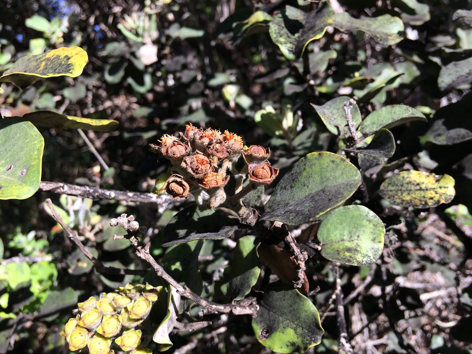
While lehua, save for the odd random ones, seem to be pretty much pau bloom, Iʻve been taking photos of a particular branch I visit on the way to Keanakākoʻi.  Trying to learn how long from bud to seed.  More or less...


 Photo above, April 24, 2018.                        


Same branch, photo below, today, August 31, 2018.


Above pic, as many are, isnʻt the best, but the seed pods are just opening (at the right).  A neighboring cluster is shown below.  The fuzzies are ʻanoʻano lehua, future ʻōhiʻa perhaps.


KOLOPUA:  fragrant, as air laden with the perfume of flowers

Though the blooming of kāhili ginger is an annual summer event up here, and the flowers are a spectacle, they are sneeze-provoking, and worse, the very thick rhizomes form mats, choking any natives desiring a foothold in the forest.  

ʻAwapuhi (gingers) bloom when days are long.  They bloom too when streetlights shine on them at night.  White ginger is a favorite, and is for me, sneezeless.  Weʻve had stretches of icky ikiiki weather...hot, nearly windless, humid, sticky, but that makes for kolopua.  Car windows wide open, driving down the hill between Glenwood and Mountain View, good noses can pick out sections where white gingers bloom, then in turn, the yellows.

I remember fondly a big patch in the back of Waipiʻo.  I call it Waimā, because itʻs not far from the end of the road there, the "index finger" of the valley.  ʻAwapuhi Waimā is white, but with a bright yellow heart


And another pesky weed up here is Glory Bush, or Tibouchina.  Easy to see why it was planted as an ornamental...


But given a choice, Iʻll take our beloved, besieged ʻōhiʻa lehua. Its tiny seeds hold the promise for future generations.  Thanks for the pic, ln...


Mauna Matters

As always, with aloha,

BobbyC
maniniowali@gmail.com

13 August 2019

Tuesday, August 13, 2019. Mauna Matters...

My mind is aswirl with topics, wonderings, musings, and other what-la.  Seems to be a busy time in many places, and keeping track of priorities can be challenging.  Our weathers here in Keaʻau ma uka have been, in keeping with the season, on the warm side for us.  Weʻve had moderate amounts of rain from Erick, and less from Flossie.  Bloomings continue, though lehua are nearly done.  Walking to Keanakākoʻi the other day, even though we saw all the yellow-flowered kūpaoa in full bloom, I was surprised and startled by the wafting of their elusive scent.  Lovely.  Ke māpu nei ke ʻala o ke kūpaoa [the fragrance of the kūpaoa floating in the breeze] from the Pukui and Elbert Hawaiian Dictionary.


I especially admire the twin curved pistils.  This plant is related to ʻāhinahina (silverswords), and sunflowers, and their seeds and waftable fluff develop in days it seems.  See if you can make out the rummaging blurry black bee.  This yellow-flowered one is a shrub, very common along the roadside to KKOI.  A cousin, with glossy dark green leaves and white flowers with a stronger scent is a groundcover on some lava flows.

And too, pūkiawe bloom with their pua liʻiliʻi (tiny flowers), extremely attractive to honeybees.  From a distance, there is but a slight change of color and texture at or near the branch tips, calling us to examine them more closely.


And already (!!!) the ʻōpelu in the yard are just budding for the season.  Readers on the Island of Hawaiʻi might search out this months Ke Ola Magazine, its cover art of ʻōpelu by Melissa Chimera.  Yup...it graces the wall near the top of the stairs (the print, not the magazine).


And, about those Mauna Matters.  At Kīlauea:

Here, we marvel and wonder at the jade-turquoisey blue-green of the pool accumulating on the floor of Halemaʻumaʻu on Sunday, August 11, 2019, pond pics by USGS HVO staff... 

A similar view can be had by visiting the K3 Cam on the HVO website:


USGS HVO

here, telephotoed

USGS HVO

We see the accumulation of yellow sulphur, and other minerals, on the walls of the lua, precipitating out of volcanic gases.  Those same gases are contributing to the color of the wai welawela (hot water) of the pool.

On August 8, 2019, this photo, as explained in the online HVO caption, illustrates "agitation" of the water (the white dots)... perhaps bubbles from escaping māhu (steam and vapors)???

USGS HVO

Another sort of māpu, this time "bubbling, splashing, as water" from the same dictionary, if indeed those spots of agitation are because gases are escaping.  Makes sense to me, but we await confirmation from the good people at the USGS Hawaiian Volcano Observatory.

"For the First Time in Recorded History" has been repeated frequently regarding this phenomenon.  Iʻd be remiss if I didnʻt wonder "Whose recorded history, exactly?"

Does "History" need to be written to be recorded?  Me thinks not.  Hawaiʻi has an extremely rich oral history; traditions of knowledge passed from one generation to the next, by those trained in memorization of chant, stories, and so on.  Perhaps one example is "The Epic Tale of Hiʻiakaikapoliopele" by Hoʻoulumāhiehie & Nogelmeier, published by Awaiaulu.  Basically Books in Hilo has Hawaiian and English copies available.  GoGet!!!  Or visit the Awaiaulu website to order:

AWAIAULU

Pages 357 to 373 (more or less) of the above, describes the death of Lohiʻau, the lover of Hiʻiaka, a younger sister of Pele.  He was entombed by pele.  Hiʻiaka sought revenge by digging through various strata of Kaluapele, attempting to extinguish the volcanic fires of Pelehonuamea.

Hereʻs a kinda junk-quality sample.  Check out paragraph 4:


So maybe the water we see now isnʻt "cold spring water", but it is water... The Tale is lovely and richly complex, and might make good bedtime reading for both keiki and adults...  This version was published in Ka Naʻi Aupuni newspaper in 1906, and translated by Nogelmeier.

And about those "pools" I mentioned in a previous post...This from a 1917 reprint of "Journal of William Ellis, A Narrative of a Tour Through Hawaii in 1823".  Excellent excellent reading.


The paragraphs describe the area of Kūkamāhuākea (Steaming Flat), between the Kīlauea Visitor Center and Kīlauea Military Camp.  The pools donʻt exist today, and may, according to some geologists, have been waters impounded by lehu (ash) erupted in the violent 1790 explosions.  During 200 ensuing years, rains, droughts, winds, and earthquakes may have all contributed to disrupting ash layers, allowing waters to drain away.

And then, as posted previously too, was the legendary Kawaiakapāoʻo, the water of the goby fish...

Water ponds in the summit region of Kīlauea?  Mauna Matters.

And then between two other Mauna...We visit Puʻu Huluhulu and explore Matters relating to Maunakea.

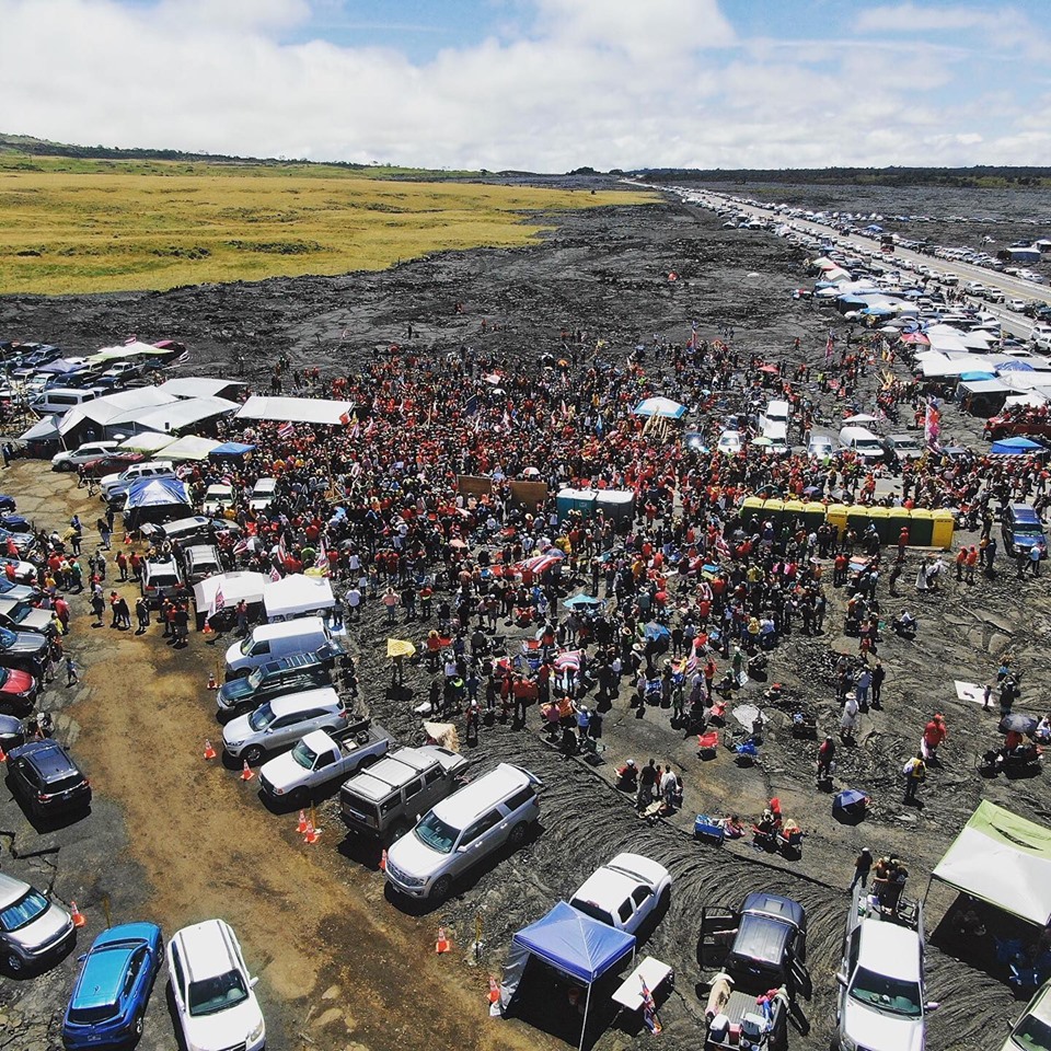
Iʻve had the ability to be able to lend support and participate up there, sharing info about natural history at Puʻuhuluhulu University.  Hot dry, misty foggy rain, whatever the weathers folks are there.  Lots of folks.  Below from the publicly available Facebook page of Kanaeokana, taken, I believe, last Sunday, August 11, 2019, view toward Hilo.


The grey lava flow (I especially love the evenly textured ropy pāhoehoe in the foreground) erupted from Maunaloa in 1935, and as Pele was making her way to Hilo, vents were bombed in an effort to divert her.

HVO 072519 Volcano Watch: MLOA pele, 1935

The map below, by Trusdell and Lockwood, was previously shared.  The most recent and incredibly detailed geologic mapping of Maunaloa helps us make sense of whatʻs under our feet.  Or tent.  1935 is magenta, Puʻuhuluhulu is the white spot with "1580".

Geologic Map: Northeast flank of Maunaloa


Puʻuhuluhulu is fascinatingly awesomely cool.  Yes, often literally, but also figuratively...  It is a puʻu erupted by Maunakea during the "Laupāhoehoe Volcanic Series", sometime between 14,000 and 65,000 years ago.  But check this out... Maunaloa, during the Puʻukāhilikū flows, an average of 1,800 years ago, or so, apparently had a radial vent (one not on a rift zone) erupt through the middle of Puʻuhuluhulu, and blanket the cinder cone with pele... like a heap of shedded coconut enrobed in dark chocolate...mmmmm Mounds Bar!!!  

Maunaloa lava was peeled off so the Maunakea cinder could be mined and used in road construction, thus the steep slope facing the highway.

Below is the technical description of the Puʻukāhilikū flow...wade through it please, and glean tidbits that may be apropos...


And too, perhaps more familiar, a USGS topographic map of the same region.  Puʻukole, at the top, is one of several on our fair isle.  Another sits just across the Saddle on the lower flank of Maunaloa.  


"Kole" perhaps because slopes resemble the color of a favorite, delicious, reef fish, kole, with its fetching yellow eyes.


The puʻu Kole, the one on Maunakea, is important.  Itʻs one of the last eruptive vents on that mauna, say 4,500 years ago.  Itʻs also a marker of the boundary between the districts of Hilo and Hāmākua.

Puʻuhuluhulu lies in the district of Hilo, in the ahupuaʻa of Humuʻula.  Humuʻula starts offshore, just on the Honokaʻa side of Kaʻawaliʻi, the third horseshoe if one is headed up the coast.  There, Humuʻula is very narrow, then heads ma uka, and turns left, its ma kai (south) boundary cutting off Hilo ahupuaʻa, preventing them from reaching the heights.  The swath of Humuʻula ends on the shoulder of Maunaloa.  Big, broad, sweeping...  Weʻll share more about Mauna ahupuaʻa in the future and why they Matter.


But, as I often do, it seems, I digress...  Letʻs share about Kapu Aloha, a guiding principle of those gathered hither and yon in their passionate efforts to protect the mauna and address a multitude of other issues, of political and social import.  Four or so years ago, hoaloha Manu Meyer penned the following: 


Please read the above carefully and thoughtfully.  The few times Iʻve been to Puʻuhuluhulu in the past weeks, Iʻve been struck by the atmosphere, the energies vibrating at that place.  Calm, thoughtful, clean, organized, and most of all compassionate and kind (Uncle...You need help?  Uncle, hereʻs some food.  Uncle, you doing OK?).  No drinking, no smoking, no anger or swearing, no rubbish strewn about.  What an amazement to witness the evolution of those speaking their minds.  Four years ago, I wasnʻt too happy with what I observed and heard going on at Hale Pōhaku and further ma uka.  This time itʻs different.  People seem centered, determined, and steadfast.  And Iʻm happy that my small-kine activism has been reawakened.

Mauna Matters

With heart-felt aloha to all,

BobbyC
maniniowali@gmail.com


02 August 2019

Friday, August 2, 2019. Imagine the Unimaginable

In the mode of


noho i waho...a maliu   be outside...pay attention

or perhaps in this instance, fly outside, pay attention.  Before last summer, who wouldʻve couldʻve imagined what happened?  Collapsing, erupting, lūʻōniu-ing, shaking seeming endlessly.  We knew and understood a bit of what had happened through centuries; various violently explosive eruptions tossing rocks and ashy bits hither and yon, blanketing landscapes, including the site of my home here at Keaʻau ma uka.  


lithic tephra strewn
at her whim unexpected
ma uka to ma kai

Lithic = rock, tephra = volcanic products falling from the sky...bigger and more than we witnessed and experienced during The Three Months.

And today is the Piha Makahiki (One Year) since our last lūʻōniu, rockfalls fortuitously captured on an HVO webcam at 11:55am on August 2, 2018:


USGS HVO

Down at Kapoho, in that cone we now know as Waiapele, was cradled a lake known by some as Green Lake.  Traditionally, according to an old map, both the cone and lake were Waiapele.


First, as pele was flowing into Waiapele, 


then, after the filling, both photos by friend Andrew Richard Hara:


And then that old map, Registered Map 366 from the State Survey Office at the Department of Accounting and General Services:


And a screenshot of part of the legend above.  The map was drawn by FS Lyman, after his survey in February 1880.  The Lyman family has had charge of land at Kapoho for generations.


And now, the Unimaginable part...or mayhaps not so much Unimaginable as Unexpected...

As if to compensate for the loss of Waiapele at Kapoho, there has been recently observed a waiapele held in the bosom of Kaluapele, at the very bottom of Halemaʻumaʻu.  May wonders never cease.

We have a tendency, especially in these times of expected hyper-quick response times via social media and email, not to pay too much attention.  We must move on to the next new thing, before we even become accustomed to this new thing.  Observations over centuries, decades even, canʻt possibly account for all eventualities and possibilities.  Imagine...

This new wai is likely a waiwelawela, heated by elemental subterranean fires, its color from various minerals and chemical reactions...

HVO Volcano Watch, August 2, 2019

This, from HVOʻs above noted Volcano Watch column, taken on August 1, 2019:


Look really good at the very bottom, that sort of jade-colored dot.  Thatʻs it.  A friend suggested that it might be meteoric water.  Wait...lest we start rumors of a meteor or asteroid having caused the formation of Halemaʻmaʻu, "meteoric" in this usage is Definition #2, as below:
me·te·or·ic

adjective
  1. 1.

    relating to meteors or meteorites.
    "meteoric iron"
  2. 2.
    GEOLOGY
    relating to or denoting water derived from the atmosphere by precipitation or condensation.

And we recall this, posted on Big Island Video News on June 7, 2019, and the paragraph following, posted here previously.  The dark streak appears to originate at the opening of a lava tube exposed just below the caldera floor, view is toward the south:


According to USGS Research Geologist Don Swanson, “What I have dubbed a “black streak” on the caldera wall is flowing water. The water comes from a shallow perched aquifer impounded by dikes in the southwest rift zone. Water flows southward along and in the sand flat below Crater Rim Drive but is stopped by the dikes, which form a dam. For one of several reasons (increasing water pressure, failure of wet sand, small rock fall), water breaks out of the aquifer and pours into the caldera. This phenomenon was first noted on July 4, 2018, and has been observed repeatedly since then. There are at least two different sites for such water flow, both just north of the southwest rift zone. The flowing water has eroded ravines or gullies that resemble cracks. Water flow generally lasts several hours and then stops as water in the aquifer is depleted. But, days to weeks later, water reappears.”

Might these two phenomena be related?  Maybe itʻs that the greenish water in Halemaʻumaʻu trickled down though that smoothish slope of fine talus after exiting a lava tube buried in the wall.  The wai may be "wai hī"...

wai 
n. Water oozing as from a precipice or trickling down. Lit., purging water.
Maybe lehu (ash) and fine rock dust have accumulated at the bottom of the lua forming a more or less impenetrable layer, maybe, maybe, maybe...
Tools available today (helicopters, drones, webcams, telescopes, and whatla) allow us to peer where we couldnʻt in past eras.  Who knows if waters were held in Kaluapele before?  We know stories of Kawaiakapāoʻo in or near Kaluapele, in which a legendary goby fish was said to dwell.  We hear of waterfowl having sported in ponds at Kūkamāhuākea, the broad area where steams rise along Crater Rim Drive (known today as Steaming Flat), and there are likely other stories of waters in the summit region of Kīlauea.  
And of course today, we enjoy the waters of Erick as they fall, knowing that rains cause life here in the rain forest, and we are thankful that they are unaccompanied by strong winds.

Raindrops trickle down the glass of the tower at HVO, perhaps eventually wending their way to, and enlarging the pool in Halemaʻumaʻu.   
Iʻve been hither and yon too these past weeks, and Iʻll leave you today with this:

A lei kokio, flowers gathered from a cultivated tree at the home of friends on Maui.  The pua, in my perhaps not-so-humble opinion, are the most spectacular of any of our kamaʻāina species.
With that, prayers for safety and warmth for those at Puʻuhuluhulu...
As always, with aloha,
BobbyC
maniniowali@gmail.com