As I type, the just-risen sun fills the living room with yelloworange glow. Already, just more than a week after winter solstice, shadow on the wall marks the towardsummer movement of the sun, just a few inches past the PostIt marker. We mark time, though Pelehonuamea works on her own unfathomable schedule. "What you see is what you get" couldnʻt be more appropriate. No matter our selfish desires, we arenʻt in control, though we may think we are...
Shall we vote for Most Scenic Workplace??? Pretty sure the above would win. Yesterday as the sun set behind Maunaloa and Pele played low-key, HVO staff were on the scene. Please note the near-absence of clouds; a rare time at the summit of Kīlauea.
Just prior to sunset yesterday, this was a webcam view in the other direction. Annotations hopefully clarify location. Kūpinaʻi Pali is a traditional name for Waldron Ledge, a popular viewpoint near the Visitor Center. "Kūpinaʻi", "echo" is what happens, especially if youʻre on the floor and call out to vertical pali. From the top, hikers can be clearly heard chatting a few hundred feet below.
And please note that "moku lana au" is a descriptor, rather than a Name. Moku = island, lana = adrift, au = to flow, as a current.
These precious days of winter clear often come with light, variable, and even slack winds...rather than scud, clouds seem to stand still as they morph and shapeshift.
They appear to be standing still, though of course they arenʻt. Gases in hot ascending fume cool and condense, form clouds, and constantly change...
A big blue sky, just ma uka of the Volcano dump yesterday. The puffball looks like the ao māhu (cloud of steam) formerly hovering over the Lua. Theyʻre related, but this Iʻd call ao uahi ʻawa, bitter (sulphurous) cloud. LookGood and perhaps the fuzziness below the ao becomes clearer. Gases from the active pit rise...
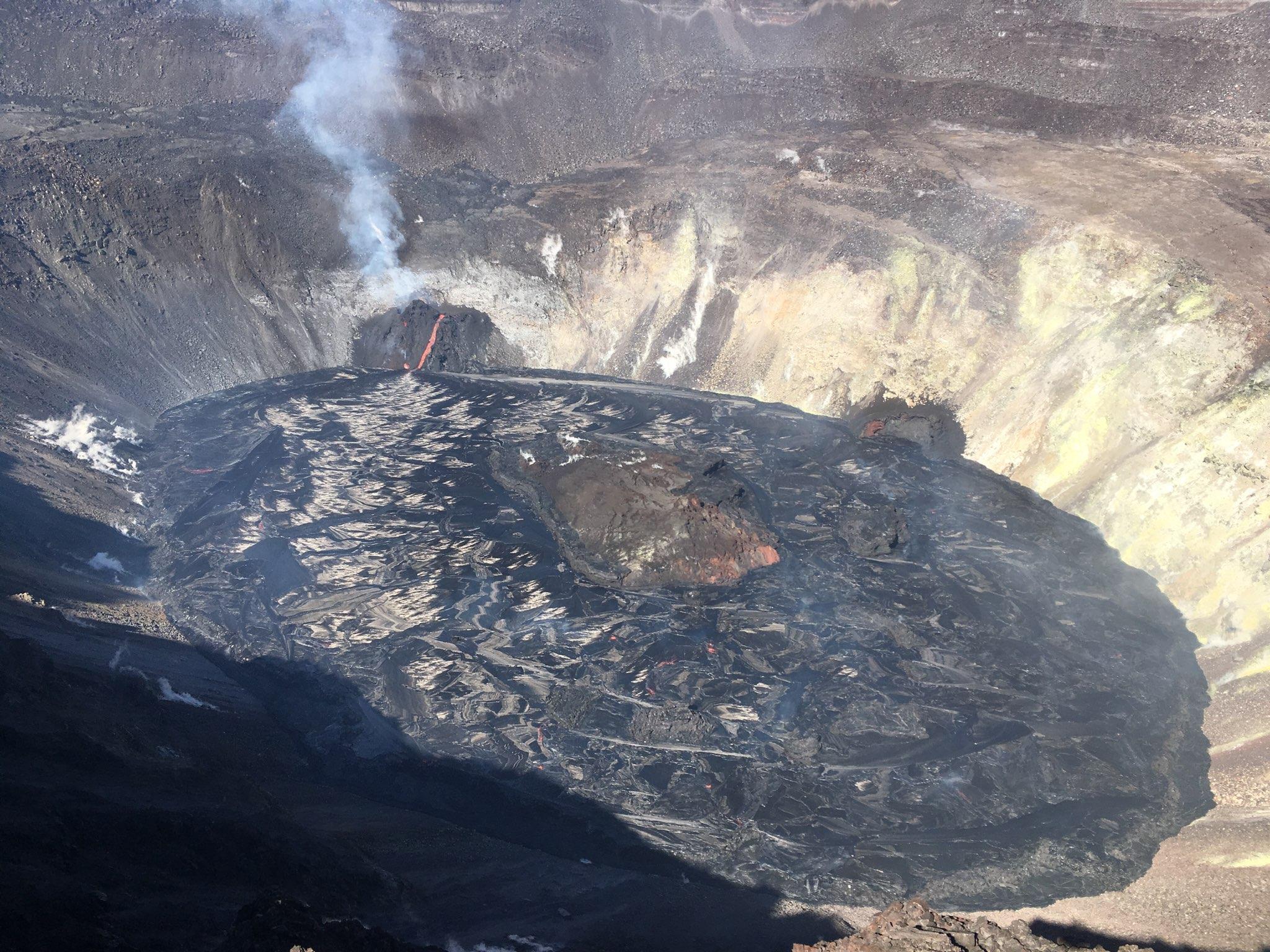
The thin, almost wispy plume of fume tells me that eruptive volume is fairly low. Those feathery "white" markings on the left-hand surface of the lava lake are silver reflections off the fresh, unaltered, glassy surface. Sun angle determines what part of the floor is reflecting. The white walls of Halemaʻumaʻu, on the other hand, are highly altered loose rubble, baked rock covered with mineral precipitates. Iron rusts, and lava close to vents, or in places like Haʻakulamanu (Sulphur Banks), are cooked...steamed...and minerals in rising gases are deposited on surfaces.
Tilt at Uēkahuna, for the moment, is declining...the surface of the ground deflates as magma is withdrawn and erupted.
The North Vent cones are active this morning, and flecks of incandescence dot the floor of the Lua. Keep in mind that while the flor may look solid, itʻs composed of separate, thin, moving plates of various temperaures, as depicted below.
Recall that whiteyellow is hottest, darkpurple relatively coolest, and moku lana au and mokuliʻi and mokuliʻiliʻi (small and tiny islands) are cool too.
The image below is from the Maps page of the HVO website. I appreciate before/after images...they help us remember what was, before often mind-altering landscape changes. Note that the geographic orientations of the inset webcam images, and that of the DEM differ by about 90 degrees.

This graphic depicts the changes to Kīlauea Volcano's summit resulting from the eruption that began on December 20, 2020. Pre-eruption topography of Halema'uma'u crater, collected in 2019, is shown on the left and compared to the topography at the summit on December 26, 2020. The models show that the deepest portion of Halema'uma'u at Kīlauea Volcano's summit has been filled with a lava lake. The eruptive vents, both active and inactive, are evident on the wall of Halema'uma'u, as are the "islands" that migrate on the lava lake surface. The December 26, 2020, Digital Elevation Model (DEM) was created from aerial imagery collected that day during an overflight of Kīlauea Volcano's summit at approximately 10:00 a.m. HST. Since then, the lava lake level has not varied greatly. As of 11:30 a.m. HST on December 28, 2020, the lava lake level is 179 m (588 ft) deep. December 26 DEM by B. Carr. Graphic by K. Mulliken.
Iʻll sign off, as helicopters, a big annoyance, thrum overhead...gotta head to town today. The Update hasnʻt been posted yet, so Iʻll let you GoLook...
Be well, take good care of each other, and WEAR A MASK...
As always, with aloha,
BobbyC
maniniowali@gmail.com


What is the difference between the ground deflating and contracting?
ReplyDelete