Thereʻs always something to clarify, adjust, take care of...and so we shall. Weathers have been...interesting. Today, again, is still and humid. Thunderstorms thundered on distant coasts of Hilo Palikū and Hāmākua yesterday, while up here, after a sunny morning, waves of kauanoe (mists) came through (see below, near the end of this post). ʻApapane happily trill their complex melodies, ʻamakihi squeak, and ʻōmaʻo provide bass notes during morning walks to Keanakākoʻi.
One morning, November 11, I awoke at 345a, and wondered: Is this it? Or do I try go sleep again? Turned out that more sleep was not to be. So I coffeed, and decided to go stroll. An easy one to Kūpinaʻi. Paved, no potholes or gravel, three independent sources of light at hand, and a route I had soloholoed often.
Above was on 111121 at 553a. I remain astounded astonished amazed. Yes, itʻs fuzzygrainy, but itʻs so evocative of a Volcano School painting of the late 1800s. See the two hōkū near the top? I was so entranced that I canʻt remember who was where. I remember Orion and Sirius, but canʻt recall placement. Weʻll leave that loose end for clarification later.
On the 9th at about 9p, was this from Uēkahuna, with gratitudes to sz. I see
Tiger Eating Moon Whilst Saturn, Above, Watches
Two bright dots below are artificial lights.
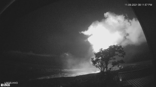
And from one of the HVO tower cams, about the same time, same ao māhu...Winds were slack, and so fumevapors were compact, loko ahi was fairly active, and thus the brightness.
We know that the kuleana of Pelehonuamea is molten lava, her pele. The fumes and vapors and steams are the province of Kūkamāhunuikea (Kū-ka-māhu-nui-ākea). The steaming flat between Volcano House / Kīlauea Visitor Center and Kīlauea Military Camp is named Kūkamāhuākea according to Deshaʻs "Kamehameha and His Warrior Kekūhaupiʻo".
And the pali on which lies "Kīlauea Overlook" is Palikapuokamohoaliʻi (Pali-kapu-o-kamohoaliʻi), he being a brother of Pele who guided the family to Hawaiʻi from Tahiti on their canoe.
I was minding my own business, sitting on my pōhaku noho at Keanakākoʻi on 111221, and looked up:
Looks to me like a manō on the attack, mouth agape. I came home and shared it Kaikea, who returned the following. He had photographed this 9 or 10 foot female tiger shark that same morning, after not visiting them since July. Manō are his family aumakua, and he is defending his MA Thesis tomorrow, about pono ways to identify them.
This was in about 75ʻ of water. Two left-hand-side fish are wahanui, and the bottom one an ʻōmilu. Biggest external anatomical difference between male and female sharks is that males have "claspers" between their Pelvic and Anal fins, as below.
Meanwhile, back on land, revisiting our Hilo tallest niu from a couple posts ago, again on busy 111221, UH Extension Forester JB Friday measured it: 95 feet to growing tip. Silly me supposed that niu keep on growing growing growing... I was reminded that as with almost every other living thing, they stop growing. Just like us and other animals and plants: Reach Maturity, Stop Growing. Plus, as JB pointed out, itʻs kinda hard to pump water and nutrients up a hundred feet.
And while an "End" this isnʻt loose. Or maybe itʻs a beginning??? When I was sharing up the Mauna in Fall 2019, I may have posted this map of Kaʻohe, a perplexing amazement of an ahupuaʻa on our Island of Hawaiʻi. Itʻs VERY narrow at shore, then wraps its arms around Maunakea, runs across the Saddle been Maunakea and Maunaloa, and goes into Mokuʻāweoweo, the summit caldera of Maunaloa.
Hoping itʻs legible here.
If too hard to read, GoVisit the State of Hawaii Dept of Accounting and General Services (DAGS) Map Search site:
And by "Registered Map No.: type in 1641
Youʻll be able to download this and a multitude of other archival maps (BEWARE: VERY VERY deep rabbit hole!!), and be able to zoom in and see
Those two parallel lines between "Sea"and "Coast"? Thatʻs the ma kai portion of Kaʻohe. I went with
np last week, and his steady hands took this. Kaʻohe is that little section mid-frame. And, please note, Dear Readers, above, right-hand-side note: [+ Boundary between Hamakua & Hilo]. Itʻs Honokaʻa-side of ʻŌʻōkala.
Thick layers of grey dense ʻaʻā core alternate with tanorangish ʻaʻā clinkery rubble. Big wavewashed ʻiliʻili and ʻalā at base of pali, crowned by legacy paina (ironwoods, Casuarina sp.) planted by sugar plantation folks WAY back in the day (late 1800s) as a windbreak to protect coastal canefields from being burnt by ʻehu kai (salt spray). Please note that "paina" is not the same as pāʻina:
pāʻinanvt. Meal, dinner, small party with dinner; to eat a pāʻina.
Yesterday, as mentioned, was a return to Kūpinaʻi with a kuʻu dear friend. Was about 10 or 1030, and skies were more blue than not, until the first wave of kauanoe mentioned earlier rolled in on east winds. Kind of a busy sky, with thick dense ao māhu at right, and wispy "regular" cloud behind. At left mist obscures a little pali. So many subtle textures and shades of whitegrey.
And yes, Pele continues her creative work in Halemaʻumaʻu, nestled in Kaluapele. Next two images from HVO on 110921, a day of light breezes, same day as Tiger Eating Moon.
Source of ao māhu, the west vent:

Hiki? Hoping so... Be well, and mask up, be socially distant, wash hands, stay home if sick...all actions for the good of all.
Always, aloha, always,
BobbyC
maniniowali@gmail.com


Mahalo! Beautiful shots. Much appreciated. Because we have experienced the views, they mean that much more to us. We're getting VOG here on Maui/Waiakoa, believe it or not; something we have not had in a long time.
ReplyDelete