The scale of whatʻs happened during the past month is breathtaking. But if we recall our histories, and the histories of Pele and her pele, "Unsurprising" is a word that comes to mind.
I saw my first eruption at Kīlauea iki in 1959. At night, during the high fountaining, glow could be seen over the shoulder of Maunakea from our home in Honokaʻa. Then in early 1960, we went to Kapoho to watch, from the porch of the school, as Pele worked there. Those flows are now being buried. And in the 1980ʻs and 90ʻs, I watched places I had come to love be buried. Only snapshot memories remain. Wahaʻula, with the big red cinderstone embedded at the base of the wall. Why? And the big deep crack with pools next to the path at the bottom. And those wiliwili. And the tree molds of recumbent loulu trunks near the ehukai-shrouded cliffs. And the lama and ʻōhiʻa forests, and the ʻohe ma kai. And the ʻiliʻili at Kaʻiliʻili. And Punaluʻu (the pond many called Queens Bath). I watched it fill with pele, at night, mostly alone save for f/z, in late March 1987. And the scent of rotten mango. And Kamoamoa with its heiau, and for a time, a huge beach of the blackest sand of shattered pāhoehoe. And Laeʻapuki crumpled windmill, house sites here and there. And Puʻu Manawaleʻa and its kiʻi pōhaku, tumulus nearly a twin of Puʻuloa. And the giant boundary ahu ma uka of the road. And the heiau with its wiliwili on the brow of Paliuli. And the steppingstone trail across that bit of ʻaʻā. Why not just go around? And the petroglyphs on those stones. And the sand dunes near Drainpipe. And Kaimū. And HarryK. And those ponds. And the laughter of children.
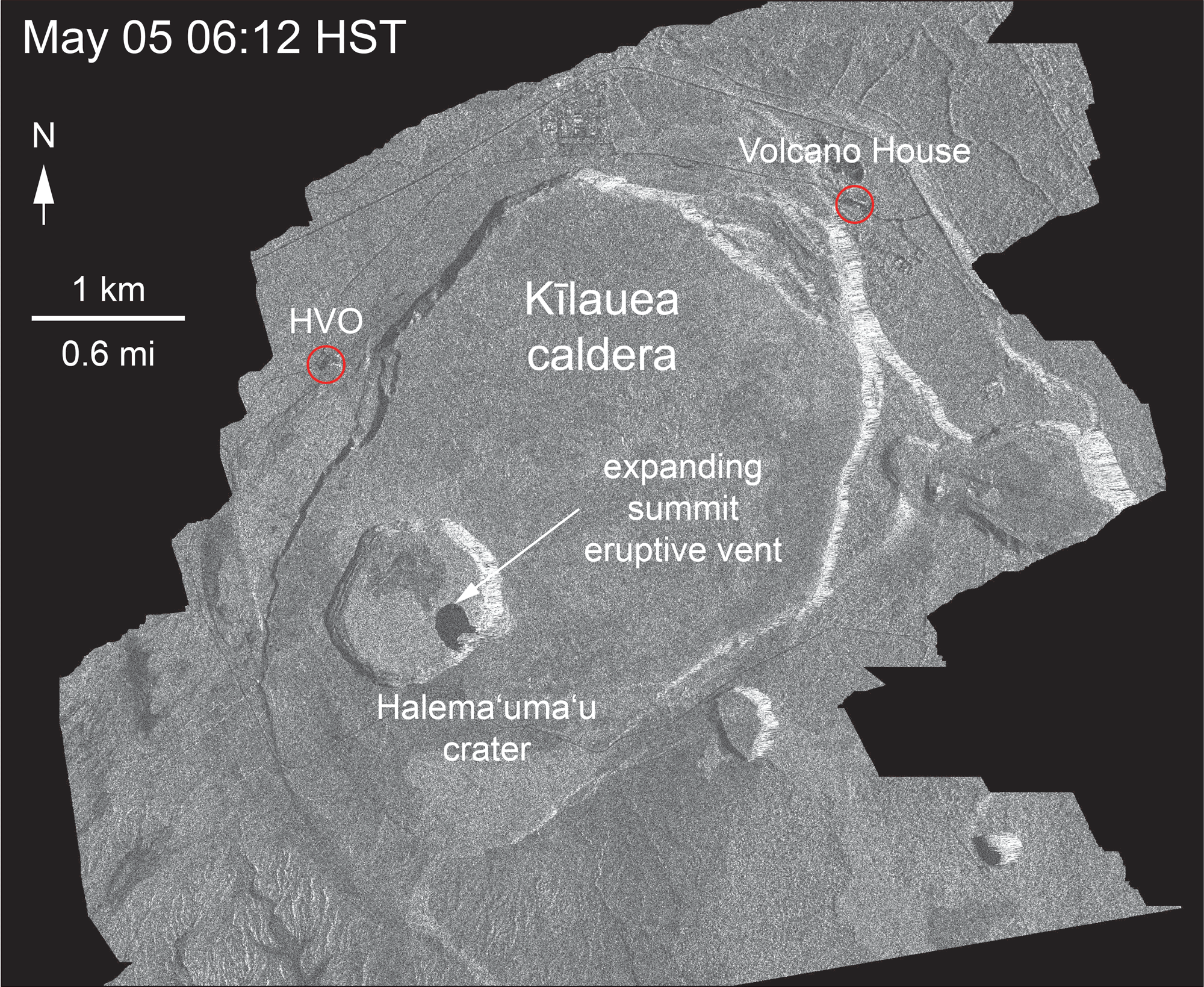
And here we are. ʻOlaʻi continue up here, while winds figure out what to do. The air was hauna yesterday, and still kind of is. The view from Volcano House is of noeuahi (volcanic haze). Emissions of lehu seems to be more infrequent, though steaming continues, vigorous at times, from Halemaʻumaʻu. And its Kaʻū-side perimeter continues to slump. See the short animation from USGS HVO at the link below:
Changes at Halemaʻumaʻu
 |
| slack trades, upright plume, noeuahi |
 |
| ʻōlaʻi the past 24 hours |
This morning up at the source in Keahialaka:

There is an abundance of photos and video online. Most striking:
Yesterday morning at 930 or so, an ʻaʻā flow, 10 to 15 feet thick, crossed HWY 137, isolating the oceanside community of Kapoho, as well as Pualaʻa and Kua o ka Lā Charter School. Apparently there are a few hardheads still in Kapoho.
At about 10a, Pele decided to take a sharp right and visit "Green Lake" in Kapoho Crater. She apparently found the waters to her liking, and drank till it was dry at 130 or so yesterday afternoon.

Context is difficult above, but go youtube "green lake steam" for a clip or two taken from ma uka of the cone.
And because fountaining continues unabated in Keahialaka, the enormous stream of pele continues unabated too. As of 730 this morning, she was 430 yards from the sea.
This screenshot from late yesterday afternoon. Look at
http://www.bigislandvideonews.com/
for the source from Senator Kai Kahele, a member of the National Guard.

And family and friends have, and will likely, lose property. And while we know and understand that change is the only constant, we grieve nevertheless. We know. We know that this belongs to Pele. We know that. But watching our ʻāina aloha be transformed is still, for a time, painful.
As always, with aloha,
BobbyC
No comments:
Post a Comment