Whew! Though weʻve seen lots LOTS more sequential rains (three months, one time), itʻs always a relief and joy to lala (bask) in the sun. And even better when said basking is at Kūpinaʻi pali on a rim of Kaluapele. So lucky.
kū.pinaʻi
nvi. 1. To echo, reverberate;
The ʻōhiʻa below: the one on the right, recently succumbed to likely a cocktail of maladies. ʻŌhiʻa die-back (cohort senescence), thrips, Rapid ʻŌhiʻa Death (ROD) paha, invasive species, etc., ...and the left-hand one is in sad decline. Fortunately, the uluhe in foreground is happy and healthy.


I find it interesting that to the right of the moku nui, there are repeated long narrow lobes of pāhoehoe, one on top of the other. The leading edge of the most recently active is that thin orangish line. How come? Because... And, looks like west vent is mostly crusted over. For now.

Excellent closeup! We see the bounding pali of the moku, 25 feet or so tall, and at its base, successive lobes and lobelets of pāhoehoe marching around the bend, the wide crack separating west (L) and east (R) papa o ka loko ahi (surface of the lava lake).

 Ha come: ānuenue and ʻānuenue? Hmmm. In conversation with a friend: "The inadvertent ʻānuenue is a product of someone who thought those words would look more Hawaiian if we scattered some decorative ʻokina in them."

Speaking of marching:
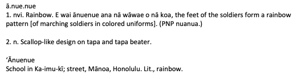
NOTE: Supposed to be ānuenue. We must be care full when spelling. ʻOkina (ʻ), and kahakō, the stress line over the vowel, changes the meanings of words. Cannot make anykine. Though many do. Even if not intentional, compilers of Dictionaries err. They misspell words, forget to include something germane...all of us are human and make mistakes.
The Update:


And then thereʻs this:

If you look closely, you can make out a relief carving (or pecking) of a kiʻi pōhaku (glyph-petro). What what why when? I know the current where location. Full of curiosities is our ʻāina.
Thatʻs it for today.
As always, with aloha,
BobbyC
maniniowali@gmail.com
No comments:
Post a Comment