Kaluapele

On the Island of Hawaiʻi, Kaluapele (the pit of pele or Pele) crowns the summit region of the volcano Kīlauea.

06 June 2018

Kīlauea Update, June 6, 2018, morning...Unfathomable

unfathomable
pele wrought alterations
new realities

So one time I was in Waipiʻo at a SlowFood Hawaiʻi gathering at the Mock Chew place.  They had made an imu, and I was ono for that crispy skin that gets stuck to the chicken wire.  I stood patiently not too far away and watched them uncover the imu, take off the hāliʻi, and reach down to lift out the wire basket with the pig inside.  Drooling with anticipation.  I watched intently as they opened the wire and began to take out the cooked pig.  And then.  Though I has seen the pig, and knew that there was a pig in there, it dawned on me that they had kaluaed pork butts.  There was no pig.  There was no crispy smokyono skin.  Talk about sad...

We see what we want to see.  We see what we expect to see.  We arenʻt always as attentive as we should, or hope to, be.

be outside...pay attention      noho i waho...a maliu

And so, when presented with a picture of the newly remodeled home of Pelehonuamea at Halemaʻumaʻu, we go..."Wow...  What is that?  Where IS that?"


Above, from the USGS HVO website:  https://hvo.wr.usgs.gov/cams/   Look under "Photos & Video".

How can???  The view is looking west toward Mauna Loa, with the green pastures of Kapāpala Ranch at the top.  Note the concentric cracks all the way around.  One running  through the Halemaʻumaʻu Parking Lot, those three curved lines at the left.  The black April 1982 spatter rampart runs diagonally down on the right (Shout out to 1982 UCSantaCruz gang).  The whitish Jaggar Museum and HVO buildings are perched on the rim near Uēkahuna at the top right edge.
Breathtaking.  New pali, multi-level, dusted in pale grey lehu.  Seems like plenny people paint their rooms grey these days...
And lest we be content with this iteration of her work, Pele continues.  We shouldnʻt be surprised if this, too, changes.

If you desire, watch the LiveStream of Halemaʻumaʻu from a cam in the tower at HVO:

Halemaʻumaʻu aLive Cam

Tilt at the summit, as recorded in the UWEkahuna vault seems to show a very slight easing of subsidence starting at 6p yesterday.  But what do I know...


We had a real ʻōlaʻi up here yesterday at 726p, a M2.7 centered near Kīlauea iki.  Good little jolt, unlike those slow ʻami exploquakes.


And the ʻōlaʻi at the Lower East Rift Zone (LERZ) are quite quite modest in number.  Two during the last day:


 The pre-dawn brightness of Fissure 8 and her river...


Just after sunrise, a bit better context below.  The fountain seems to be waning just a little, and USGS says that fissures uprift may be reawakening.  Again, go read Macdonald 1955 for an idea of whatʻs possible.  We tend to get complacent, and after a week of the same old same old, we forget that the situation can and will change.  Sometimes too fast for us to get our bearings.


Courtesy of GoogleEarth, Kapoho Beach Lots before...1960 flow to right:


and Vacationland Hawaiʻi, before...1955 flow to left:


Match the below with the image just above.  The houses aflame below are the blue-roofed ones at lower left above.


On the Vacationland Hawaiʻi Community Association website is a timely, evocative, lovely piece written about the 1959 and 1960 eruptions.  Please take the time to read it.  Thanks, Papa.  Tis an excellent reminder that history has a way of repeating (and repeating) itself:

http://vhca.info/docs/1959.pdf


And with that, Iʻm taking a few days off to relax on more stable (hopefully) ground.

As below... maybe go beach, make ʻili hau, gather pua kou, and kui lei.  And yes, those are bananas at the beach...we werenʻt fishing.


Weʻll catch up early next week sometime, then.

As always, with aloha for our ʻāina aloha,

BobbyC

05 June 2018

Kīlauea Update, TUE, June 5, 2018, again in the morning

Eō Pelehonuamea!

What impressive works of all manner weʻve witnessed.  Hard to absorb it all, much less make sense of it.

A NOTE:  Iʻll post an update tomorrow morning, Wednesday the 6th, then will take a few days off.  Back here, paha, by next Tuesday the 12th. Iʻve greatly appreciated the many comments from you folks.  Thanks for participating.

And NOTE2: Try go look at Hawaiian Force in Hilo.  Craig made a nicenice tee shirt commemorating the luaʻi pele.

OK...what to write???

At Keahialaka, her fountain continues to play, though seemingly a bit diminished, and we wonder...  we browse again through Macdonaldʻs USGS Report of the 1955 eruption, and wonder... [again, the link:]

USGS 1955 Macdonald

Early morning, before the PGcam switched to color, so we can better see her fires, and know that  the river still flows.

Then with better lighting, we see that the luaʻi pele seems a bit diminished.  Yes, the new cone of pōhāhā (tephra) is bigger, but the height of the fountain is shorter too.  We wonder...


and we review the duration of historic Lower East Rift Zone (LERZ) eruptions, and wonder, and wonder, and wonder...  Pretty much all we can do.  Wonder at the wonderment of it all.  No sense ask "Why?", because the answer going be..."Because...".

And ʻōlaʻi for the last week are very infrequent at the LERZ:


The shore of Kapoho has been irrevocably altered.  But but but some of the properties have been, for now, spared.  The pele made substantial progress toward the deep sea because nearshore waters were very shallow.  Sea level rise has been trumped (couldnʻt resist that one) by much more rapid and incremental coastal subsidence events because of the various workings of Pele.  Please review RegMap 1777 of yesterday and examine notes written thereon.


The kīpuka above remains, so far.  Itʻs the hilo-side extent of what used to be the community on the shore of "Champagne Pond", that body of tepid volcanically heated water.  The slightly darker pele at the bottom and right, with the double-lined track is the 1960 flow.  Yesterdays pele is the tannish still-smokesteaming at the left.  The rise of Waiapele (Kapoho Cone) at the top.

On Registered Map 366 by Lyman, surveyed in 1880, we found "Waiapele" yesterday, middle of first full line of text:


a closeup of the text.  "Aupuni Road" on map above, is "Government road" below:


Today, this puʻu is referred to variously as "Kapoho Crater", "Kapoho Cone", "Green Mountain", etc.  What about using Waiapele?

And too, please see Peter Youngʻs info about this on his excellent blog:


Note that there are frequent inconsistencies, for various reasons, between "o-class" and "a-class" names.  You ʻōlelo Hawaiʻi peoples are welcome to chime in.  Please.

Pele lapping at the former loko wai.  View more or less ma kai, active pele moving top to bottom:


And then after... And I ask again, How and Why the sharp right turn?  A correspondent said he remembered seeing something that our late friend Ulu Garmon posted or said about the moʻo of the pond winning a battle with Pele.  Not this time...  Stay tuned for more info if it becomes available.


Both photos immediately above from Andrew Richard Hara a couple days ago.  Mahalo piha for sharing.

Nuff at the shore...

Up here, another exploquake, a 5.5 at 432a, .9 miles deep.  Relatively shallow.  House rolled around a bit, but nothing major.  Again, the magnitude scale seems to be off, but itʻs the bigger red dot at the left rim of Kaluapele.  And if it really WAS a regular earthquake, the photos below might explain why.


So I was noodling around yesterday afternoon, looking kinda obsessively at webcams, and wondering...

Up at Kaluapele, it was a clear tradewindy afternoon.  Very little lehu or māhu emitted from Halemaʻumaʻu, so I did a SaveAs at 540p.  Strong trades are blowing light grey ash in the distance.  What appears to be the rim of Halemaʻumaʻu, that dark wedge at the bottom, is in fact the rim.  But.  Itʻs sunk.  And everything to its right, and disappearing behind the fat ʻōhiʻa branch, is...sunken.  SUNKEN.  We behold a brand new pali (cliff) or two, a sloping sunken block, amazing!  Makes a few sections of broken pavement and a cracked terrace at Jaggar positively pale by comparison.


And I looked at it and looked at it and scratched my head and looked at it and tugged my beard and looked at it and...HOLY %#%@!!!  Am I REALLY seeing what I think Iʻm seeing??? The ash-covered folds of lava dotted by mostly faya trees, and that tall, sharp, dark, fresh pali...

Then I rummaged through old files and found the below, from August 23, 2016. at 710a.  Same tree.  Same camera.  Same photopoint.  But see how flat and calm it is.  Just above the (old) rim of Halemaʻumaʻu, above the big whitish spot, you can spy Crater Rim Drive, that grey line, headed up to the right, and through the caldera bounding fault toward the Southwest Rift Zone pullout.  Remember that?
And I had to fuss with exposure a bit as best I could, and try crop so theyʻd kinda match as above.  

And then I put them together on one sheet.  The two photos are from the KIcam in the tower at HVO (Hawaiian Volcano Observatory), from a thankyou-for-foresight fixed point on the floor.

Be nīele, keep looking, 

be outside...pay attention   noho i waho...a maliu

REALLY pay attention...

And thatʻs whatʻs new...

As always, with aloha,

BobbyC

04 June 2018

Kīlauea Update, Monday, June 4, 2018, morning, pohō Kapoho

pohō kapoho
malalo iho pele
haliʻa aloha

lost is kapoho
under blanket of pele
cherished memories

[mahalo kuʻuhoa pn for the inspiration] 

And, as she has for millennia, Pelehonuamea continues her work.  I contemplate in wonderment while marveling at her efficiencies.  On her way ma kai from Keahialaka, refreshment was needed, and she drank from lakewaters.  Not long after, perhaps hungering for iʻa (fish), she visited first the fishponds at the head of the bay at Kapoho.  This craving for fish, we have seen, is a common thing for her.  Three loko iʻa (fish ponds) in Kekahawaiʻole, Kona ʻĀkau (North Kona), fed Pele in the 1800ʻs:  Pāʻaiea at Keāhole, on the flank of Hualālai in 1801, and Wainānāliʻi and Kīholo, those ponds on the slope on Mauna Loa on either side of Keawaiki, in 1859.  And now Pele dines at Kīlauea, at Kapoho in Puna ma kai.  Hualālai, Mauna Loa, and Kīlauea were the sources.  Three luaʻi pele from three of our mauna, provided three different place settings and meals.

Kumukahi, that wahi pana (legendary place) at the eastern tip of Hawaiʻi, is the first to greet the sunrise.  The surrounding area has been, and continues to be a place of geologic unrest.  The East Rift Zone of Kīlauea enters the Pacific there, and weʻve learned that many eruptions have happened nearby:  in 1840, in 1955, and in 1960.  Those are ones whose tales have been told in writing.  Native Hawaiian residents of the region centuries past witnessed great upheavals too:  the creation of Kapoho Cone perhaps 200 to 400 years ago, pele flowing into the sea periodically over several hundred years, repeated intrusions of magma shaking and cracking the ground, and swaths of shoreline subsidence.  All of these works of Pele in Puna are legendary and are well-documented in chant and in writing.

Starting with a USGS Geologic Map:

The older flows: p3 = 750 to 1,500 years old, p4o = 400 to 750 years old, and p4y and pc4y = 200 to 400 years old.


Then, from the State Survey Office, one can explore many, many archival maps.

Hereʻs a screenshot of their page with the url.  The "1777" in the yellow box is the Registered Map Number.  You can download the Index by clicking on the pdf link Registered Map Index next to the yellow box.


This is a portion of RegMap 1777, Surveyed and Drawn by A.B. Loebenstein in 1895.  To see the full map, follow the instructions above.  Zooming in reveals a plethora of info:  trails, caves, holua, many place names, etc.


Then a closeup of the fishpond Pele visited starting at about 1030 last night.  Itʻs the square in the middle: "Sunken walls of Fish Ponds".  And to the right, just below "HALEKAM[AHINA], the text reads "Coast Line 1883 Survey now covered high tide".  Remember that the area was surveyed for this map in 1895.  Ongoing, continued, episodic subsidence...


Below was yesterday evening.  A spectacular "vent to terminus" shot.  Fish pond walls clearly visible at the head of the bay:


And this morning, the fishponds are gone.  Note that the steaming ma uka of the shoreline comes from many small landlocked ponds scattered through the area.  And those wisps of steam rising from the surface of the sea = waiwelawelawela.  Too hot for us.


Fountaining at Fissure 8, the source, continues unabated.  ʻŌlaʻi, thankfully, are few and far between, though that may mean that there is an open conduit for the erupting lava.  Not necessarily a good thing for those hoping for this to end soon.  But one never knows...


BACK TO THE SUMMIT REGION:

Yesterday, the BIG news was the BIG "earthquake" that "rocked" the Big Island.  Media words, not mine.  And the No Tsunami Was Generated message.  Not mine either.

Hereʻs my version of whatʻs going on.  And to repeat, again, I have NO credentials in the academic fields of seismology, geophysics, volcanology, etc.  I just go

be outside...pay attention     noho i waho...a maliu

And I read a lot.  And have some really smart, generous, friends.  OK?  Starting on or about Lei Day (May 1), because of the draining of Puʻuʻōʻō, the LERZ intrusion, etc., the lava lake in Halemaʻumaʻu (HMM), and the summit region in general, started to subside or deflate.  As more and more magma exits the summit region, the ground sinks and sinks and sinks.  Five (5) feet and more so far was the last I heard.  That sinking is demonstrated by many many many ʻōlaʻi (earthquakes).  That process continues.  Somewhere between May 9 and 12, the withdrawing lake encountered ground water at the watertable.  We had our first HUGE ash emission on May 15.  Silent, big, impressive.  More followed.  More earthquakes.  More lehu (ash).

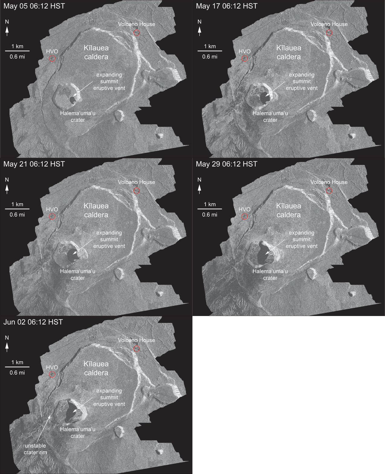
On May 31 or so, we got a peek inside the newly refurbished HMM.  Deep and impressive, encircled by concentric cracks on the floor of Kaluapele (the caldera).  Then I think last Friday, June 1, I noted a difference in our ʻōlaʻi.  They had evolved into ʻami.  That rotation-of-the-hips hula motion.  Sometimes to the right, sometimes to the left.  Slow ones.  Not violent, though of long duration.  

This is the pattern Iʻve come to discern, for what itʻs worth...a day or so when the ground doesnʻt move much, followed by a day or so of increasing wobbles and queasiness, then they become more and more frequent, then a big ʻami and a big concurrent (more or less) emission of lehu.  Then we relax and breathe, and repeat.

Late yesterday, USGS noted:

A moderate earthquake (5.5 preliminary) resulting from a volcanic explosion and continued collapse around Halemaumau occurred at 15:50 HST. 

So I think that these exploquakes are different than regular (if there is such a thing) rockfracturing earthquakes.  I visualize Pelehonuamea with a tickly throat.  She starts coughing, first infrequently, then more and more.  Her throat is that long deep conduit from the surface, down to where ever.  Her coughs rise, circling up the pipe.  Then finally, in a paroxysmal fit, she manages to clear her throat, and expels the irritating lehu. This happens in a circular fashion so we are able to distinguish her expectorations from her footstompings and groundsettlings of "regular" ʻōlaʻi.  Or something.  Or not.  

A bit of tannish lehu from the lua on the far side, and her white māhu closer...


And our earthquakes for the last day or so, with the BigOne highlighted.

I am WAY late sending this into the ether.  Lots to mull, consider, and share.  I trust that you are learning too.

As always, with aloha...and with fond memories of Kapoho.

BobbyC

03 June 2018

Kīlauea Update, SUN, June 3, 2018, afternoon: Kapoho

ahhhh...ʻōlaʻi continue up here, while down there, at the eastern tip of our island, very near Kumukahi...

Green Lake, embraced by the arms of Kapoho Crater, was filled yesterday (060218) afternoon.  Compare, if you will, the following two maps.  The first, surveyed in 1922 and published in 1930, depicts nearly all the same features as the second, and includes the route of the Consolidated Railroad.


A current USGS topo below differs from the above primarily because it outlines the Lava Flow of 1960.


The aerial photo below was taken by USGS this morning at 7.  The fishpond wall labelled on the topo is clearly visible.


 With a bit of turning, the map below can be compared with the photo above.  That fat redness  on the map is perhaps a consequence of the flattish terrain allowing pele to spread.
Auē...

BobbyC

Kīlauea Update, Sunday, June 3, 2018, she travels through

Dizzying.  Sometimes incomprehensible.  Perplexing.  Or not.

The scale of whatʻs happened during the past month is breathtaking.  But if we recall our histories, and the histories of Pele and her pele, "Unsurprising" is a word that comes to mind.

I saw my first eruption at Kīlauea iki in 1959.  At night, during the high fountaining, glow could be seen over the shoulder of Maunakea from our home in Honokaʻa.  Then in early 1960, we went to Kapoho to watch, from the porch of the school, as Pele worked there.  Those flows are now being buried.  And in the 1980ʻs and 90ʻs, I watched places I had come to love be buried.  Only snapshot memories remain.  Wahaʻula, with the big red cinderstone embedded at the base of the wall.  Why?  And the big deep crack with pools next to the path at the bottom.  And those wiliwili.  And the tree molds of recumbent loulu trunks near the ehukai-shrouded cliffs.  And the lama and ʻōhiʻa forests, and the ʻohe ma kai.  And the ʻiliʻili at Kaʻiliʻili.  And Punaluʻu (the pond many called Queens Bath).  I watched it fill with pele, at night, mostly alone save for f/z, in late March 1987. And the scent of rotten mango.  And Kamoamoa with its heiau, and for a time, a huge beach of the blackest sand of shattered pāhoehoe.  And Laeʻapuki crumpled windmill, house sites here and there.  And Puʻu Manawaleʻa and its kiʻi pōhaku, tumulus nearly a twin of Puʻuloa.  And the giant boundary ahu ma uka of the road.  And the heiau with its wiliwili on the brow of Paliuli.  And the steppingstone trail across that bit of ʻaʻā.  Why not just go around?  And the petroglyphs on those stones.   And the sand dunes near Drainpipe.  And Kaimū.  And HarryK.  And those ponds.  And the laughter of children.

And here we are.  ʻOlaʻi continue up here, while winds figure out what to do.  The air was hauna yesterday, and still kind of is.  The view from Volcano House is of noeuahi (volcanic haze).  Emissions of lehu seems to be more infrequent, though steaming continues, vigorous at times, from Halemaʻumaʻu.  And its Kaʻū-side perimeter continues to slump.  See the short animation from USGS HVO at the link below:

Changes at Halemaʻumaʻu

slack trades, upright plume, noeuahi

ʻōlaʻi the past 24 hours
And while up here, aside from the problematic winds, things are pretty much oia mau nō, kind of the same, Puna ma kai is witnessing major changes.

This morning up at the source in Keahialaka:


There is an abundance of photos and video online.  Most striking:

Yesterday morning at 930 or so, an ʻaʻā flow, 10 to 15 feet thick, crossed HWY 137, isolating the oceanside community of Kapoho, as well as Pualaʻa and Kua o ka Lā Charter School.  Apparently there are a few hardheads still in Kapoho. 

At about 10a, Pele decided to take a sharp right and visit "Green Lake" in Kapoho Crater.  She apparently found the waters to her liking, and drank till it was dry at 130 or so yesterday afternoon.


Context is difficult above, but go youtube "green lake steam" for a clip or two taken from ma uka of the cone.

And because fountaining continues unabated in Keahialaka, the enormous stream of pele continues unabated too.  As of 730 this morning, she was 430 yards from the sea.

This screenshot from late yesterday afternoon.  Look at

http://www.bigislandvideonews.com/

for the source from Senator Kai Kahele, a member of the National Guard.


And family and friends have, and will likely, lose property.  And while we know and understand that change is the only constant, we grieve nevertheless.  We know.  We know that this belongs to Pele.  We know that.  But watching our ʻāina aloha be transformed is still, for a time, painful.  

As always, with aloha,

BobbyC

02 June 2018

Kīlauea Update, Saturday, June 2, 2018, Lauahi Pele i kai o Puna

Lauahi Pele i kai o Puna, oneʻā kai o Malama
Pele swept her many fires down to Puna; seaward of Malama is a cinder heap.

in the Pukui & Elbert Hawaiian Dictionary, online at wehewehe.org :

one ʻā
nvi. Black sand or gravel made of ʻaʻā lava; volcanic cinder; to form such; gunpowder. Lauahi Pele i kai o Puna, oneʻā kai o Malama (chant), Pele swept her many fires down to Puna; seaward of Malama is a cinder heap.

Itʻs a bit of a challenge sometimes to figure out what to say and how to string thoughts together.  Though I donʻt speak Hawaiian, I believe I have some understanding of themes and concepts related to things Hawaiian.  As a naturalist, what knowledge I have is like the sea and its shores:  sometimes somewhat deep, sometimes shallow, at times broad, and other times narrow.  Because Iʻm so nīele, I often get sidetracked or distracted.  But my view of learning is itʻs like assembling a jigsaw puzzle.   Some pieces are connected quickly, while others sit and languish waiting to be made part of the whole.

Thereʻs been a lot of geologizing of late, and appropriately so.  But the cultural aspects of the current pele sometimes falls by the wayside.  I am NOT an expert in these matters, but digging around often yields bits and pieces of sometimes enlightening information.  And bringing things to the surface helps inform our thinking and perceptions.

Sometimes I sit and browse through the dictionary.  Wandering around, forth and back, seeing what all is in there.  Yesterday, it was what became the headline above.  It caught my attention because Malama is where, recently, Pele made a brief visit to the sea, just NE of MacKenzie State Recreation Area.  


Some believe that Pelehonuamea and her people are the stuff of fairy tales.  Others, myself included, have come to understand that she was a real person, deified because of her various powers.  Her exploits have become legend.  Go google and read any number of books, articles, etc.  She apparently first came to the Island of Hawaiʻi at the place Keahialaka.  By now that should ring familar, as itʻs the ahupuaʻa in which sits Leilani Estates.  The map below, surveyed in 1922, shows a number of lua and puʻu, all constructed by Pele, as well as the ahupuaʻa Keahialaka and Malama, and the Lava Flow of 1840.  It should not surprise anyone that sheʻd want to revisit those places.  How many of us have favorite beaches, parks, forests, etc., to which we frequently return?  Guessing quite a few...


Over the years, we mature and accumulate knowledge.  Hereʻs something Mrs. Kanahele and Duke Kalani Wise penned back in 1989, perhaps an early version of her Ka Honua Ola, recently published by Kamehameha Press:  KP "Ka Honua Ola"

Ka Honua Ola, Kanahele & Wise, 1989

Thanks to Scott Rowland for posting the link.

In what I think is an accessible and understandable style, Kanahele and Wise share stories and educate us about perceptions of Pele.  A main point is that these understandings are current and real.  Itʻs not something "Hawaiians used to do", or practices that are so often described in the past tense.  Itʻs NOW.  Itʻs TODAY.  And itʻs been being for hundreds of years and manymany generations.

In the 1989 KHO, there is mention of "Waiakea".  Not the Waiakea we know today in Hilo, but one at the shore by Kumukahi on another 1922 topo (below).  

And we just learned that this morning, Pele is back visiting, and crossed HWY 137, the coast road, close to where "Kapoho School" is marked below.  She was there in 1960, and nearby in 1955.  


Pieces of puzzle.  And a reason I get SOOO annoyed with people who seem not to be able to learn and use correct place names.  "A-Bay", "Queen-K", "Camp-K"...  And one of the most egregious in this Hāmākua boys estimation: "Hāmākua Coast" these days apparently starts at Wailuku River and the Singing Bridge, and goes all the way  to Waipiʻo.  It.  Does.  NOT.  Hāmākua, the district, does start on that coast, but not till just past ʻOʻōkala, at Kaʻula Gulch.  From there, back to the Wailuku, is Hilo Palikū (Hilo of the upright cliffs).

OK  OK  OK....

Up here at the summit region of Kīlauea, thereʻs pele happening too.  

Yesterdays post of that spectacular breathtakingly dramatic droneage (drone footage) of Halemaʻumaʻu...Stlll WOW...  Go look slowly and pause at appropriate views.  See the cracks and slumping of the floor of Kaluapele, and the complex new topography of Halemaʻumaʻu.  I did a totally lame calculation of the depth:  measured with a ruler on my screen, the rim to old floor (2"), and rim to deepest part of floor (6").  Old depth = 280 feet (x) 3 = 840 feet.  But what do I know???


I know that our ʻōlaʻi are MUCH fewer today than yesterday.  See the paucity of red?  The Earthquake in the target above was in Mauna Loa Estates, where I live, just to illustrate proximity.

I know that Kumu NK told us that Makuanani seem to move differently than the younger set.  I think she said itʻs perhaps that we spend/spent more than them time outside swimming, planting, working the land, and so those motions are more natural to us.   And that those motions are the basis for many of those in hula.

And I know that her favorite ʻami is ʻakau.  And that my easiest is hema.

And I know, because I was sitting at desk in my loft,  that the M5.4 ʻōlaʻi yesterday afternoon at 137p was an ʻami ʻakau.  A  slow  ʻami ʻakau, except the entire hale was moving.  And kept moving.  Almost silently.  An ʻami ʻakau pele.  Clickclickclick the pieces come together.

And I know now that before a big emission of lehu (ash) from Halemaʻumaʻu we have more and more frequent ʻōlaʻi, hours of them, then usually a biggish one, then the lehu, then we settle and get quiet.  Till the next one.

And I know that as of 555 this morning, Pelehonuamea was still at work in Keahialaka.


And I know that up here, sheʻs still at Halemaʻumaʻu, 060218, 640a


And I know how different she looks now than not so long ago, 082316, 710a


And I know that her works will continue.  Below is the text of a chant, printed in the newspaper Hae Hawaii on March 21, 1860.  Iʻve bolded lines with geographic references to familiar places in Puna ma kai.  The url is at the top.  Iʻm incapable of translating it, but do have an appreciation for the work.


As always, with aloha,

BobbyC

01 June 2018

Drone Overflight of Halemaʻumaʻu, Thursday, May 31, 2018: The Abyss

Hereʻs the link:

drone overflight Halemaʻumaʻu, THUR, May 31, 2018

And a screenshot:


The dark, nearly horizontal line at the upper right that intersects the rim of Halemaʻumaʻu (HMM) is the April 1982 spatter rampart.  That rampart is on the floor of Kaluapele (the caldera).  

The floor of HMM is the grey area at the left, with its dark wall rising and nearly obscured by fume at the upper left of the image.

The lua (pit) inset on the floor of HMM is the MUCH enlarged vent that opened in March 2008.

There is a deeper section on the far side of the main lua where apparently much of the steam is being emitted.  

Instability, caused by more than 5 feet of subsidence during the past month, is demonstrated by the many cracks ringing the floor of Kaluapele surrounding HMM, as well as on the floor of HMM itself.

Wow....  This is the caption at the end of the film.

BobbyC


Kīlauea Update, Friday, June 1, 2018, in the morning

not the quaking earth
ohelo kaulaau shake
mejiro forage

Maintaining a modicum of stability (pun intended, I think...), while the hale wobblescreaks more periodically than desirable.  The view from the kitchen window ma kai includes an ʻōhelo kaulāʻau, placed not in a tree as its name would have us think, but growing out of the earth on the side of a tumulus, thinly covered with ash, grass, leaf litter, and what-la.  The ʻōhelo shrub is perhaps six feet tall, and deciduous.  It lost its foliage several weeks ago, and is now adorned with fresh green liko (young shoots or growth) transforming into lau (leaves).  Hiding under the new leaves are clusters of pua (flowers).  Mejiro (Japanese white-eye), a small olive green bird with a white circle around its eyes, climb and flutter under and through the branches seeking nectar and bugs.  

And this has what to do with ʻōlaʻi, luaʻi, luaʻi pele, pōhāhā, uahi ʻawa, kūkaepele, and māhu, one might query?  Well...all of those named phenomena:  earthquakes, eruptions, lava flows, tephra (volcanic ejecta falling from the sky), sulphur smoke, sulphur, and volcanic steam, all of them and more, over millennia, have shaped the lands on which we dwell.  They all influence what we see and experience.  And theyʻre all interconnected in that Papakū Makawalu way (please google for more info).

And we muse, wondering, what next?  What will Pelehonuamea gift us with today? This is a challenging time, this not-knowing.  This be-here-nowness.  Unsettling, exciting, all of it.  Halemaʻumaʻu is ever-changing these days.  Steam-ash-steam-and-ash, varying intensities of each.  We watch webcams and wonder.  Thatʻs all we can do.  There is no script or program. At 855 this morning from Volcano House (dark ash left, white steam right):


And a bit earlier today from HVO, at 7am:


And below, the ʻōlaʻi up here for the last day or so.  Some days are busier than others, and thankfully the majority are of a magnitude too small to feel, but still, so far since waking today, Iʻve felt three or four.


and down there, in Puna ma kai, Pele remains impressively busy too

Pretty sure you folks have been looking at photos and video.  Mindbogglingly amazing.  Now thereʻs at last, a Mandatory (for real) Evacuation Order for the majority of Leilani Estates in Keahialaka.  And evacuation orders for other communities whose roads may soon be cut off.  Just before 9 this morning, a flow was about a half mile mau ka of the "Four Corners" intersection, by Kapoho Cone.  Try play with various layers on the Civil Defense map, using the icons at the upper right after the map is opened:

Civil Defense Lava Flow Map

Hawaiʻi Fire Dept, Wednesday, May 30, 2018

Though the fountains of a few hundred feet high continue, mercifully there have been fewer earthquakes.  

FLASHBACK to Kapoho village in 1960 (My second eruption. I watched it with my family from the porch of Kapoho School).  Kumukahi is to the right.


On the map below, that dark circular area near Kumukahi is Kapoho Cone, a very prominent landmark 200-400 years old according to the 1991 USGS Map I-2225.


Kapoho Cone occupies the SE corner of the intersection of Highways 132 (ma uka of Kapoho) and 137 (the road parallel to the coast):


And a thermal image, below, depicting the scope of the flows.  White = hot.


Think Iʻll end for now.  With thanks and gratitude to all the hardworking people from various agencies whose works make this blog possible.

As always, with aloha,

BobbyC